My previous post provided background information, including location map, about the Basque Coastal Geopark (https://landscapes-revealed.net/the-basque-geopark-60-million-years-in-20-km/). This post provides more details about this extraordinary sequence of sedimentary rocks called “flysch” (pronounced “flish”). When you are in the Geopark, you will constantly see this word.
The fancifully-decorated FLYSCH sign is advertising “Guided activities during all of the year”. The boats for guided tours (routes shown by dotted blue lines) all have this insignia, as do the guides’ t-shirts. The red dots and lighter green color indicate the limits of the Basque Geopark. The yellow dots indicate guided tours by foot.
Other sightings of “flysch”: on street signs showing where to go to see flysch (upper right), as the name of a surf shop (lower right), and even as the name of a local wine (left). Txakoli (cha-ko-li) is the name for a varietal (hondarrabi zuri) that I think is unique to this area. It’s bright and tasty!
What in the world is flysch?
Flysch is an archaic word that was coined in 1827 by a Swiss geologist who used the term for layers of alternating thin layers of sandstone and shale in the Alps. The name comes from the German word fliessen, which means to flow. Geologists later realized that these were deep marine sediments and then applied the term to layers deposited in a “geosyncline [basin] shortly before a major orogeny [mountain-building event]”. This was before plate tectonics had been discovered and today the term “geosyncline” is meaningless.
We now know these alternating layers were deposited by turbidity currents and that they can form in a variety of marine environments. Sure, the layers in the Geopark were deposited in a basin that was later uplifted during the Alpine orogeny, but there was a long time in between these two events that occurred in two very different tectonic environments.
This photo shows “flysch” layers along the coast of Zumaia. This old term continues to be applied to thin layers of alternating sandstone and mudstone, plus or minus limestone, and that is unlikely to change. I have to admit that it’s a fun word, everyone in the region knows what it refers to, and most don’t realize it has an outdated (and erroneous) meaning. But now YOU know the truth. Nevertheless, from here on, I’ll give in to the reality of local usage!
Sedimentology 101: turbidity currents and pelagic sediments
The “flysch” layers were deposited by two processes: (1) sediments that were carried from shallow water to deep water by turbidity currents, and (2) sediments that originated in the ocean and then sank to the sea floor.
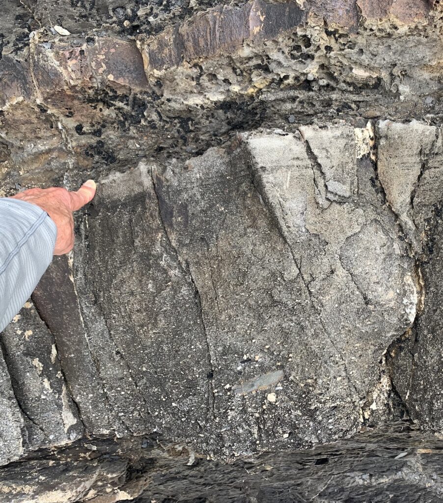
I found this small-scale “model” of a turbidity current on Deba Beach—really close to ancient layers deposited by these currents! Imagine that this flat piece of sand is the continental shelf, with land on the right and a slope to the deep ocean on the left. The water flow is laminar (sheet like) on the shelf, but when it reaches the steep slope it turns turbulent. These flows can continue for long distances in the deep ocean. As they slow down, the sediments settle out to create what we call a “turbidite” layer.Here is a sequence of turbidites (the more resistant sand layers) alternating with mud. The turbidity flows happen when sediment from land gets carried seaward. In between flows, mud settles very slowly from suspension. This sequence is at Saturraran Beach at the western end of the Geopark (just west of Deba on the map below). See my previous post (link at top of page) to see what the ocean basin looked like at that time. As described in my previous post, the layers were uplifted and titled during the Alpine-Pyrenean Orogeny (collision between the Iberian and Eurasian plates).Here are some closeups of turbidites. Left side: This is a closeup of one of the sand beds at Saturraran Beach. Notice that the sand grains are bigger on the bottom and smaller at the top. This is because, as the flow slows, the bigger grains fall out first, followed by the smaller grains. Above and below the sand are layers of mud. At the top is a thinner turbidite (sand) layer. Right side: A closeup of a sequence of thin turbidite sand layers (tan color) separated by layers of mud (black color). This sequence probably took hundreds, or even thousands, of years to accumulate on the seafloor. If you interested in learning more about turbidity currents, here is a good, and brief, tutorial: https://geologyistheway.com/sedimentary/turbidity-currents/.Pelagic sediments are most commonly of biologic origin, and are deposited on the seafloor far from land. In the Geopark, the pelagic organisms are primarily foraminifera (left side—a single-celled protist) and coccoliths, the hard parts of nannoplankton (right side—a single-celled algae). They both have hard parts made of calcium carbonate and are only visible with high magnification. They live in surface waters and when they die, their hard parts settle through the water column to the seafloor. Where abundant, they create calcareous ooze that eventually hardens into limestone. These sediments accumulate at rates of around 5 cm (2 inches)/1000 years. Red clay, mostly from wind-blown dust, is another pelagic sediment that, in the Geopark, gives some of the limestone layers a reddish color. Wikipedia has a decent explanation of pelagic sediments: https://en.wikipedia.org/wiki/Pelagic_sediment.
Touring the flysch
The “flysch” can be viewed by car, boat, train, bus, or foot. The most complete views are via boat or foot. As described in my previous post (see link above), the best viewing is during low tide, particularly during times with large tidal ranges. So some pre-planning is useful.
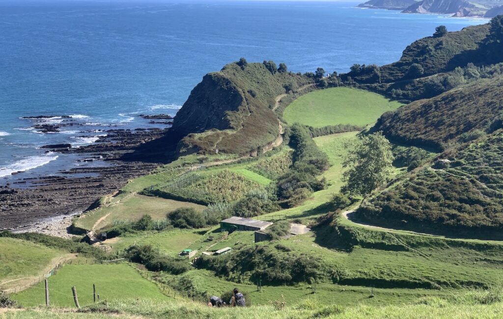
This map shows most of the Basque Coastal Geopark—the part that extends between Deba and Zumaia (black letters on left and right sides of map). There is a fabulous 14-km (8.4 mile) trail that enables visitors to hike the entire distance. The numbers refer to points of interest along the way that are referred to in the park’s downloadable guides (https://geoparkea.eus/en/what-see/geo-routes). What’s great is that you can take the train or bus one direction and hike the other direction. We choose to take a 15-minute train ride from Zumaia (where we were staying) to Deba, and then hike the trail back to Zumaia. We had to drive to visit the westernmost part of the Geopark at Mutriku and Saturraran Beach (see map in previous post and “flysch” at Saturraran above).Deba Beach, at the western end of the Geopark trail, is a good place to see the “flysch” and the surf. We enjoyed seeing these boys getting their first surf lesson. Impressively, several detailed signs along the promenade described the “science of surfing” and included detailed information about how waves and tides work. Deba Beach is a good place to see some interesting features of the turbidite layers. Left side: a thin turbidite layer with “cross bedding”—inclined layers formed as the current created ripples that, in this case, were moving from right to left. Right side: jumbled layers that may have resulted from earthquake shaking that dislodged the layers and caused them to roll around. We could tell this happened soon after deposition because the layers above are not disturbed. We call this “soft-sediment deformation” because it occurs on the seafloor while the sediments are still in a semi-consolidated state.From Deba, we continued eastward along the coastal path (see The Flysch Route map above), with incredible views along the way. This view is of Sakoneta, one of the few places where the trail goes down to beach level. At the bottom of the photo, you may notice two people descending the trail, which is part of El Camino del Norte that connects San Sebastián and Santiago de Compostela. We passed some groups of “pilgrims” along this trail.
The most famous part of the flysch at Zumaia
Because the continuous layers at Zumaia were deposited during major events in Earth’s history, it is one of the most studied and referenced sedimentary sequences in the world. The cross section below shows the geologic ages of the sequence and the events that are recorded there. Although the lower (older) part of Geopark “flysch” is mostly sequences of turbidites, the upper (younger) part at Zumaia is mostly pelagic sediments, with only occasional turbidite layers. This implies that the area was farther from land. As a reminder, the Geopark sequence was deposited during ~60 m.y., from ~110–50 Ma.
This image shows the Zumaia sequence from west (oldest layers) to east (youngest layers). The ages of the 10 m..y. part from 65.5 Ma to 55.8 Ma (K/T to P/E) are certain. But the layers extending east and west of this part include at least another 10 m.y. The upper ~15 m.y. of this sequence is shown in the photo at the top of this post.
The top line are the names of the Periods: Cretaceous, the end of the Mesozoic Era, and Paleogene (formerly the Tertiary), the beginning of the Cenozoic Era. The Paleogene is divided into two Epochs: Paleocene and Eocene. The Paleocene is divided into three Stages (D/S/T).
From oldest to youngest, the labelled events are: (1) K/T—Cretaceous/Tertiary boundary, although it should be labelled K/Pg since the Tertiary is now the Paleogene. (2) D/S—the boundary between the Danian and Selandian stages of the Paleocene. (3) S/T—The boundary between the Selandian and Thenatian stages of the Paleocene. (4) P/E—the boundary between the Paleocene and Eocene Epochs. Boundaries are based mainly on fossil content and typically mark times when there was a significant change in organism populations.
The next photos show the boundaries listed above.
This K/Pg boundary (K-T on the cross section above) marks the world-shattering mass extinction event that ended the Cretacous Period and the Age of Dinosaurs. Like the Gubbio site in Italy that we visited in 2022 (https://landscapes-revealed.net/discovering-what-killed-the-dinosaurs-in-gubbio-italy/), these layers are mostly pelagic sediments. The lighter-colored layers are limestone that are mainly microfossils of forams and coccoliths (see images above). The reddish, more recessive layers are marl—mud that is a mixture of microfossils and red clay. Pelagic sediments accumulate slowly but continuously, so they are excellent recorders of Earth events. At the edges of oceans, the flow of large amounts of sediment from land can easily obscure subtle signals.
Left-side photo: The K/Pg boundary is at the contact between the reddish layers and the orangish layers. Keep in mind that this sequence could have taken nearly a million years to accumulate. The alternation between limestone and marl could reflect alternating climate conditions, or other global or regional conditions.
Right-side photo: Jay is pointing to the recessed layer that is the K/Pg boundary. At the level of his head, you may be able to see a thin white streak that is the ~1 cm-thick iridium layer that was the critical clue—an out-of-this-world asteroid terminated the lives of dinosaurs and many other groups (see my Gubbio post for more info). Jay and I sat here for some time reflecting on the enormity of this Earth event. The sediments he is sitting on are filled with fossils of organisms that ceased to exist after the asteroid impact. It’s sobering to contemplate—how many thousands or even millions of years are represented by the recessed layer that is the duration of time until Earth’s environment had recovered and new organisms began to thrive (orangish layers in the left-side photo). Right-side photo: This is D/S—the boundary between the Danian and Selandian stages of the Paleocene. Jay is in front of the reddish layers that are above the boundary. It is marked by a change in populations of coccoliths (calcarous nannoplankton). Left-side photo: This is S/T—the boundary between the Danian and Selandian stages of the Paleocene. It is marked by a reversal in Earth’s magnetic field. At each site there is a white sign explaining that this location is the global reference point for this boundary.The Zumaia sequence is also famous for its diversity of trace fossils. Most people are used to seeing fossils that are body parts like shells or bones. Trace fossils, in contrast, are the impressions that organisms leave in the sediments as they forage for food. An entire field of geology (ichnology) involves the study of ichnofossils to figure out what type of organism made the trace or track. Left-side photo:zoophycus, a trace fossil thought to be made by a type of worm. Right-side photo: I do not know the name of this trace fossil but the organism certainly had a complex feeding pattern. These trace fossils are on the surface of sand layers—turbidites. Occasionally, sand from land was able to travel far enough into the ocean to interrupt the pelagic rain of sediments from the ocean’s surface.
The P/E boundary is not very scenic because there is only red clay layers that are recessive and covered with grass. This boundary is also called the PETM (Paleocene Eocene Thermal Maximum). This was a time of extreme temperature increase that lasted about 100,000 years. The layers at Zumaia, and other PETM sites around the world, are being carefully studied to learn information applicable to today’s climate changes.
Here is another photo of Zumaia—looking westward along the coast, with the San Telmo hermitage on the cliff top. The layers are tilted toward us, and we are just seeing their planar tops. Zumaia is an incredible spot—scientifically important but also very beautiful.Two last photos from Zumaia. Left-side photo: This old mill was using tidal energy to grind grain from 1200-1885. It’s an example of how people had figured out how to generate renewable energy 1000 years ago! Right-side photo: Flysch girl (courtesy of Jay Ach). Yep, as a sedimentary geologist, Zumaia was my happy place!
From our personal lesson, I now think I’ll (mostly) be able to ID which direction a turbidite layer is moving! All of this is fascinating, especially while I’m going through the Green Spain portion of the Spanish Wine Scholar course. It talks about soils and their formations in each of the four regions and your recents posts take that discussion much further. Now I’d love to get back to País Vasco and see more formations and soil IRL!
Landscapes Revealedon October 12, 2023 at 9:02 am
I already want to go back too – maybe we can meet near there again next year!


From our personal lesson, I now think I’ll (mostly) be able to ID which direction a turbidite layer is moving! All of this is fascinating, especially while I’m going through the Green Spain portion of the Spanish Wine Scholar course. It talks about soils and their formations in each of the four regions and your recents posts take that discussion much further. Now I’d love to get back to País Vasco and see more formations and soil IRL!
I already want to go back too – maybe we can meet near there again next year!