We completed a 10-day trek in Los Picos in early September—arriving in Arenas de Cabrales on 3 September, trekking from 4–13 September, and continuing onward from Arenas on 14 September. It was a self-guided trip. We worked with a company called Natural Adventure, who made our lodging reservations and provided us with apps, maps, and other information we used to complete the circuit that is described on their web site: https://www.thenaturaladventure.com/tours/spain/picos-de-europa-circuit/. In this post, I’ll describe the route. For more background information about Los Picos, please see my last post: https://landscapes-revealed.net/los-picos-de-europa-a-history-of-collisions/.
This map shows the location of our trek in the Parque Nacional de Los Picos de Europa (area encompassed by dashed purple line). Los Picos consists of three massifs: Western Massif (Cornión), Central Massif (Los Urrieles), and Eastern Massif (Ándara). SELLA, CARES, and DEVA are names of the major river systems. We started in Arenas de Cabrales and completed a counter-clockwise circuit around the Central Massif. Locations we visited included Cain, Posada de Valdeón, Espinama, FD (=Fuente Dé; pink line is cable car lift), Sotres, Tielva, and Bulnes. Map is from Geology guidebook (reference below).This is a geologic map that shows our route. I’ve labelled locations with the days (#1–10) when we were there. In my previous post, I described the geologic history of Los Picos. This map shows the Carboniferous limestone layers in light blue and purple colors. Notice that the same layers are repeated over and over (from north to south) by thrust faults—lines with triangles on the north side, indicating that thrusting was toward the south. The darker colors of orange and purple are layers of sandstone and mudstone, and the green color east and west of Sotres are Permian–Triassic red beds. Map is from Geology guidebook (reference below).
Arenas de Cabrales and Day 1
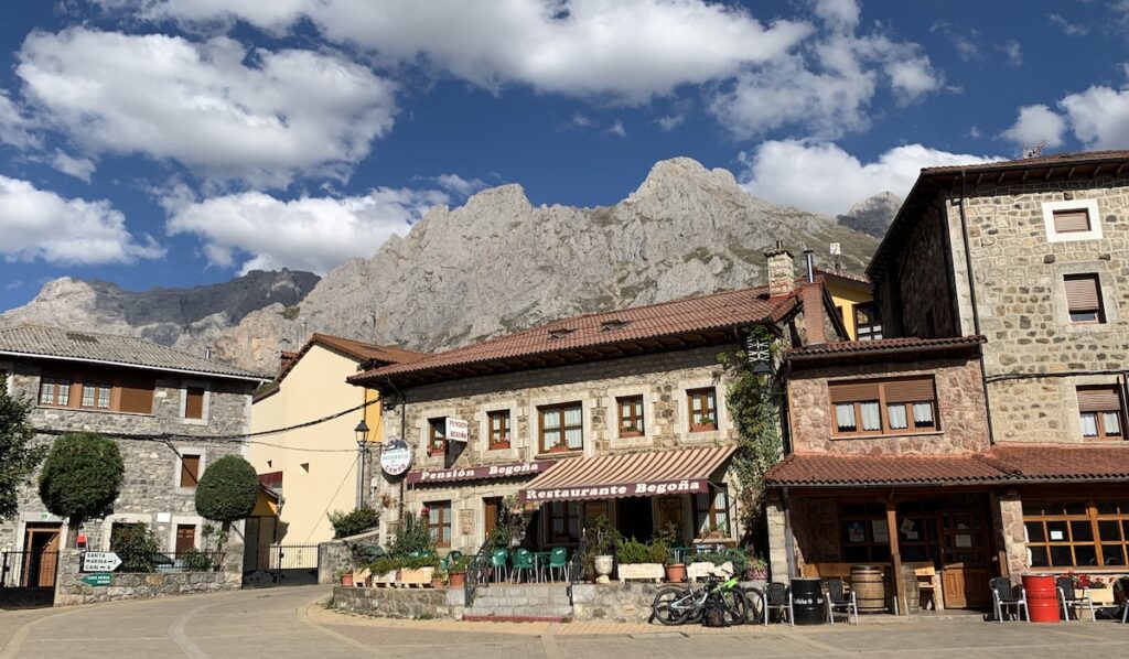
Arenas de Cabrales (north end of top map) is a convenient village located just north of the national park. With its outdoor and grocery stores for supplies, excellent restaurants and bars, and a variety of lodging types, it is an ideal base from which to start a trek. We stored some items at our hotel and retrieved them at the trek’s end. In our backpacks we needed only layers for warmth, a few changes of clothes, lunch and water.
Left photo: Team Ashland! For the trek, Jay and I were joined by friends Michael and Nanci. We were happy for their company. Right photo: We enjoyed three nights in Arenas de Cabrales, where we found good restaurants and an outdoor store to buy hiking poles. The board in this restaurant pretty well sums up the local attitude: “The best social network is a table surrounded with your people”. DAY 1 of our trek was a loop from Arenas de Cabrales, here visible in the valley to the north (Michael for scale). We hiked 10.2 km (6.5 miles), with about 650 m (2100 feet) of elevation gain. Although it was cloudy, we experienced only a little drizzle.
Day 2: Garganta de Cares (Cares Throat, i.e., Gorge)
On DAY 2, we were transported to Puente Poncebos where we hiked up a steep, narrow gorge along the Cares River (the circled 9 on the geology map above was our route). This is the most popular hike in Los Picos. We were told that, in the summer, thousands of people from all over the world hike this gorge, most of them as a day trip. In the first part of September there were other hikers, but it was not crowded. Once into the national park, we were hiking in ~350-million-year-old limestone.
We had a lovely, sunny day for this hike. Left side: A view to the west, up the canyon. Notice the trail in the upper right corner of the photo. It’s challenging to photograph the whole canyon because it is so narrow and deep. Right side: A view eastward, back down the canyon. Notice people on the trail on the left side of the photo—this is not a hike for those who fear heights!At one place along the trail, we saw this layer of conglomerate that was inset in the limestone wall. These are deposits of the Cares River when its level was much higher than today, when it was in the process of cutting downward through the limestone.
Day 3: Posada de Valdeón
After hiking 12 km (7.5 miles) up the canyon, we decided to take a taxi from Cain to our hotel in Posada de Valdeón (see maps).
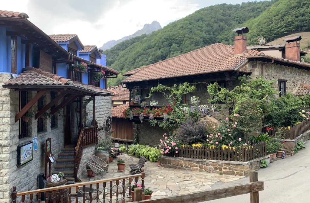
Posada de Valdeón is a charming village located in a part of the park that is less frequented by visitors. The photo shows the town center with some of its welcoming restaurants and bars. Our hotel was a short walk to the south (off right side of photo), where there was also a new Visitors Center—explained in my previous post—that provides a wealth of information about the region. On DAY 3 we completed a 16-km (9.5-mile) loop westward—with 800 m (2600 feet) ascent and descent—from Posada de Valdeón. This junction indicates the path we took westward (to the left) to Vega de Llos, and the path that goes back to town where we started. This stone house is called La Casa Vieja (The Old House), now converted into a hotel. The smaller building in front of the old house is a granary that was elevated on stilts to prevent rodents from eating the supplies. These granaries are common throughout the mountainous regions of Europe.A northwest view along our hike to where limestone layers (white color) are thrust over mudstone and sandstone layers. All of the layers are tilted to the north because of movement along thrust faults (see geology map above).On the geology map above, notice that Posada de Valdeón is located in the orange color that represents sedimentary rocks such as mudstone and sandstone. Left side: This is mudstone we found along our hike. Because the mudstone is so much less resistant than the limestone, if forms valleys. Right side: A view back to the east along the hike. Posada de Valdeón is in the valley (low-lying because it’s underlain by mudstone), and the peaks are in the limestone layers of the Central Massif. Our Day 4 hike took us along the slope beneath the limestone peaks.
Day 4: Valdeón to Espinama
On DAY 4 we hiked along the southern end of the Central Massif from Posado de Valdeón to Espinama, located in the Eastern Massif (see map at top). Left side: Shepherd’s hut along our trail, with peaks of the Central Massif in the background. Right side: We passed many grazing cows eating grass and heather (pink color) with Central Massif limestone layers in the background. Apparently it is legal to graze cattle in the national park. The day’s hike was 15.5 km (9.5 miles), with ascent (and descent) of 900 m (2900 feet).Our hotel (Ramoña) in Espinama. Our lodgings were comfortable; all provided breakfast, and some (like this one) provided dinner. If dinner was not provided in the hotel, we choose a restaurant in the village where we were staying.
Day 5: Teleférico Fuente Dé
We stayed in Espinama for 2 nights. On DAY 5, we took the teleférico (cable car lift) to explore a higher part of the Central Massif. After hiking for 10 km (6 miles) we returned to Espinama on the teleférico.
View westward from the teleférico station. The lower elevations are mostly more-erodable sandstone and mudstone, whereas the high peaks are less-erodable limestone layers.Left side: In the high elevations above the teleférico station, we saw herds of grazing sheep. They are valued for both their milk and their wool. Right side: Jay with a cheese we bought in Espinama for our lunch. This one was goat cheese, but others were sheep- or cow-milk cheese, and some were a mixture of two or three types. Each village has its own cheese makers, and of course each village thinks their cheese is the best! We thought all of the cheeses were delicious.
Day 6: Espinama to Sotres
From Espinama, on DAY 6, we took advantage of the Teleférico Fuente Dé to gain elevation. From there we hiked a mostly downhill route of 14 km (8.5 miles) eastward to Puertos de Ávila, then northward to Sotres (see locations on geology map above).
Northward view into the high peaks of the Central Massif from the top of the teleférico. From there we hiked eastward (to the right) in the direction of the signs’ arrows.This eastward view is of Puertos de Ávila. The red-roofed building is a refugio that provides lodging. Ávila was an active mining area in the 19th and 20th centuries. The geology map (above) shows an area of green that represents the black-colored mudstone visible in the foreground. The mudstone is overlain by limestone. The geology map also shows an area of white that represents sediments deposited by glaciers during the past 10s of thousands of years. My previous post shows some closeups of the moraines along the edges of the valley. The circled 10 on the geology map is our route.
Days 7–9: Hiking around Sotres
From Áviles we hiked northward in the valley that continues to the left (north) in the photo above. We spent four nights in Sotres, from where we did day hikes.
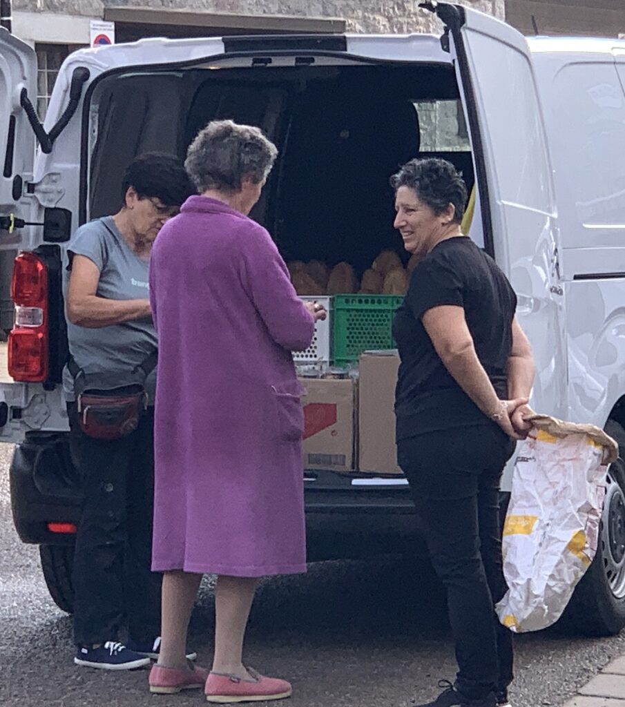
On DAY 7, we were transported to a trail head east of town, where we walked 12.5 km (7.5 miles) uphill to the old Ándara mine site (photos in previous post). The photo is a view to the west from the trail, as we headed back to Sotres—the houses in the valley. Sotres is in the Eastern Massif, which is separated from the Central Massif by the valley extending south–north (left–right) below Sotres.Michael and Nanci walking on the trail as we returned from Ándara. View toward the east in the Eastern Massif.On our hike near the Ándara mine site, we were fortunate to see several rebecos—a type of chamois that is the emblematic wild life of Los Picos. Left side: the rebecos we saw on a ledge above us. Right side: A closeup photo of rebecos from the Visitors Center in Posada de Valdeón. On DAY 8, we decided to have a low-key outing and did a 6.5 km (4 mile) trek around Sotres. Here are Nanci and Jay on a knoll west of town with stellar views of the town and surrounding mountains.An eastward view over Sotres from the viewpoint shown in the photo above. We thought Sotres would be a delightful place to linger for a month—there are good restaurants, friendly people, and many hiking options to choose from. The next group of photos capture some of Sotres’ ambience.TOP ROW. Left photo: A bicyclist sculpture we saw along a road near Sotres. Bicycling is very popular in Spain—while we were in Spain, the 21-stage Vuelta de España bike race was underway (https://www.lavuelta.es/en/). Center photo: A woman brings fresh-made bread to Sotres everyday, regardless of weather conditions. When she arrives in town, she honks her horn, and people run out with their bags. Right photo: A delicious lunch of salad with smoked salmon and goat cheese (top) and tortos (bottom), a popular Asturian food. These puffed fritters can be topped by various ingredients; here they have Cabrales blue cheese, drizzles of honey and pollen, and walnuts. Fabulous!
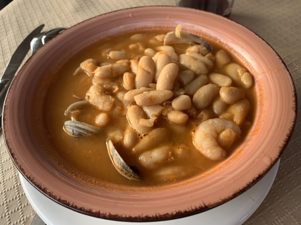
MIDDLE ROW. Left photo: Octopus dish at our hotel’s restaurant that had excellent food. Middle photo: Fabada, the most famous dish of Asturias. Although the white beans are usually in a broth with a variety of meats, this seafood version is also available. Right photo: Our Hotel Peña Castil, with a bar on the ground floor, restaurant on the second floor and in outdoor tables, and rooms in the back.
BOTTOM ROW. Manuel, our host at Hotel Peña Castil. Since I could speak Spanish with him, he treated us very well. We could have lingered longer in Sotres, and it turned out that we did add one more night than planned.On DAY 9, we were scheduled to hike up to a refugio at the foot of Picu Urriellu, in the heart of the Central Massif (see geology map for location). Unfortunately, the forecast was for thunderstorms and low cloud cover—not the best weather for climbing on exposed rock faces at high elevations. We decided to stay in Sotres another night, and choose a 7 km (4.2 mile) hike to the village of Tielve (see maps above). Although we had planned to hike back to Sotres, a downpour changed our minds and we taxied back to town instead. Jay, Nanci, and Michael happily hiking on the trail to Tielve.
Day 10: Sotres to Bulnes and Arenas de Cabrales
On DAY 10, we hiked 10 km (6 miles) westward to Bulnes (see maps above). In this valley, we got a view of Picu Urriellu, the blocky-shaped peak on the left side of the photo. After the previous day’s rain, the sky was bright and clear. Although we could have made it to the refugio on this day, our schedule required us to return to Arenas de Cabrales where we had hotel rooms and a reservation for transportation back to the coast the following day.The settlement of Bulnes with several restaurants. A funicular between Bulnes and Puente Poncebos (see geology map above) makes this an easy destination for visitors. After several hours of a slippery, muddy downhill trail to Bulnes, we opted for a funicular ride downhill to Poncebos. After one more night in Arenas, we continued on to complete the rest of our trip.Jay and I next went to Santander, capital of the Cantabrian autonomous community. Santander has a large embayment on the east side, and the open ocean on the north side. Here is a view eastward across the bay just after sunset.
Wow. Wow. and Wow. Such wonderful narration and photos. And great to have a company like Natural Adventures to make the pre-arrangements. Thank you Karen for bringing your “followers” along on your journeys, while informing our geographic, geologic (and cultural) knowledge base. ~Alice & Darryl
Landscapes Revealedon November 1, 2023 at 9:23 am
Thanks for reading — love you two!
Kathy Knokeon November 1, 2023 at 3:07 pm
So appreciate your geological travelogue. The pictures are beautiful and your commentary is fascinating. Am enjoying this virtual hike that at age 91 I could not quite manage.
Landscapes Revealedon November 1, 2023 at 3:35 pm
Thanks for reading Kathy. So glad you enjoy the posts.


Wow. Wow. and Wow. Such wonderful narration and photos. And great to have a company like Natural Adventures to make the pre-arrangements. Thank you Karen for bringing your “followers” along on your journeys, while informing our geographic, geologic (and cultural) knowledge base. ~Alice & Darryl
Thanks for reading — love you two!
So appreciate your geological travelogue. The pictures are beautiful and your commentary is fascinating. Am enjoying this virtual hike that at age 91 I could not quite manage.
Thanks for reading Kathy. So glad you enjoy the posts.