We now travel farther back in time to the Paleozoic Era when Los Picos de Europa (the Peaks of Europe) were formed in a series of sedimentary basins that were later deformed and uplifted during two major collisions between continents. This post focuses on the geologic history of Los Picos and my next post will focus on the 10-day trek we made through and around these mountains with our friends Michael and Nanci.
This Google Earth map shows the location of Los Picos de Europa and the other locations we visited on our trip to northern Spain in September. My previous posts were about the Basque Geopark (posted October 3 and 6; record of events ~110–50 Ma) and the Jurassic Coast (posted October 9 and 16; record of events ~200–145 Ma). We also visited the cities of Santander, Bilbao, and San Sebastián. Los Picos are part of the Cantabrian Mountains that extend eastward, and connect with, the Pyrenees Mountains that separate Spain and France. Notice that Los Picos encompass three massifs—the three white “blobs” above the yellow label. Most of the area is included within Spain’s national park system—Parque Nacional de Los Picos de Europa.Here is a southward view of Los Picos, with the Central Massif on the right (west) side of the valley and the Eastern Massif on the left (east) side of the valley. This view is from Sotres on Day 8 of our trek, after we trekked northward through this valley on Day 6.
Collisional history
This paleo-map is a reconstruction of the tectonic plates 356 Ma (Ma=million years ago). It shows convergence of the Euramerica and Gondwana plates that by the end of the Paleozoic Era (250 Ma) had consumed all of the ocean between them and formed the super-continent called Pangea. These continental collisions created an immense mountain range similar to the Himalayas today. In Europe, they call this mountain-building event (i.e., orogeny) the Variscan Orogeny. In the U.S., we call it the Appalachian Orogeny. The Appalachian Mountains along the U.S. east coast are the eroded remnants of that major geologic event. Notice that Spain (arrow points to Variscan Mts) was located in a tropical latitude at that time.
Later on, during the Triassic Period (~250–200 Ma), the continents began to separate as the North American and Eurasian/African plates moved apart and the Atlantic Ocean began to open.
By 50 Ma the North American and Eurasian/African plates were continuing to separate, creating a wide Atlantic Ocean between them. In contrast, the Africa and Eurasian plates were moving toward each other, creating a series of collisions as the Paleotethys Ocean (see map above) was consumed. From about 50–10 Ma, the collision of Africa with southern Europe—called the Alpine Orogeny—created many mountains, including the Alps, Dolomites, Pyrenees, and Cantabrian Mountains. The collision between Africa and Europe will likely continue until the Mediterranean Sea (remnant of the Tethys Ocean) is all consumed. These paleo-maps are available at: http://www.scotese.com/.
We had the good fortune to be in Posada de Valdeón just 15 days after a new Visitors Center had opened. It contains a huge amount of information about the geology, biology, and cultural history of Los Picos. Valdeón is located in a valley between the Western and Central Massifs. The diagrams below are photographs of information presented in the Visitors Center.
Events during the Variscan Orogeny
(1) Gondwana plate (see 356 Ma paleo-map above) subducts beneath the Laurentian plate (core of North America), moving the continents together. The oldest Picos rocks were deposited in this ocean.
(2) Plates continue moving together; almost all of the oceanic part of the Gondwana plate has been subducted.
(3—lower part) The Variscan Mountains are created once the ocean has all been subducted and the continents (too bouyant to subduct) collide.
(3—upper part) Close-up of the ocean east of the Variscan Mountains. Sediments eroded from the mountains flow into the ocean. Spain was in the tropics, where warm water promotes the growth of organisms such as corals that make their hard parts of calcium carbonate. The most prominent parts of Los Picos are limestone (blue color) created by these organisms. Also found in Los Picos are conglomerate, sandstone, and mudstone (yellow–green colors) that were deposited closer to land.
Events since the Variscan Orogeny
(5) By the end of the Carboniferous Period (~300 Ma), the continents had fully collided and the intervening sedimentary rocks had been compressed to form the Variscan Mountains. Notice that the layers (e.g., red layer) are repeated and stacked on top of each other—this is due to movement along thrust faults. The elevated mountains were then being eroded.
(6) During the Permian and Triassic Periods (300–200 Ma), the mountains were eroded to a flat plain and river sediments were deposited on top of the stacked layers of tilted sedimentary rocks. Most of these rocks have a reddish color.
(7) From 50–10 Ma, a collision between the African and Eurasian plates—the Alpine Orogeny—created more thrust faults that further deformed the sedimentary layers. The yellow lines indicate the Alpine-aged thrusts that offset the older, Variscan-aged thrust faults.
(8) Since the Alpine Orogeny uplifted these mountains again, they have been eroded by many elements, notably by glaciers during the last 2 million years.
Photos illustrating Los Pico’s collisional history
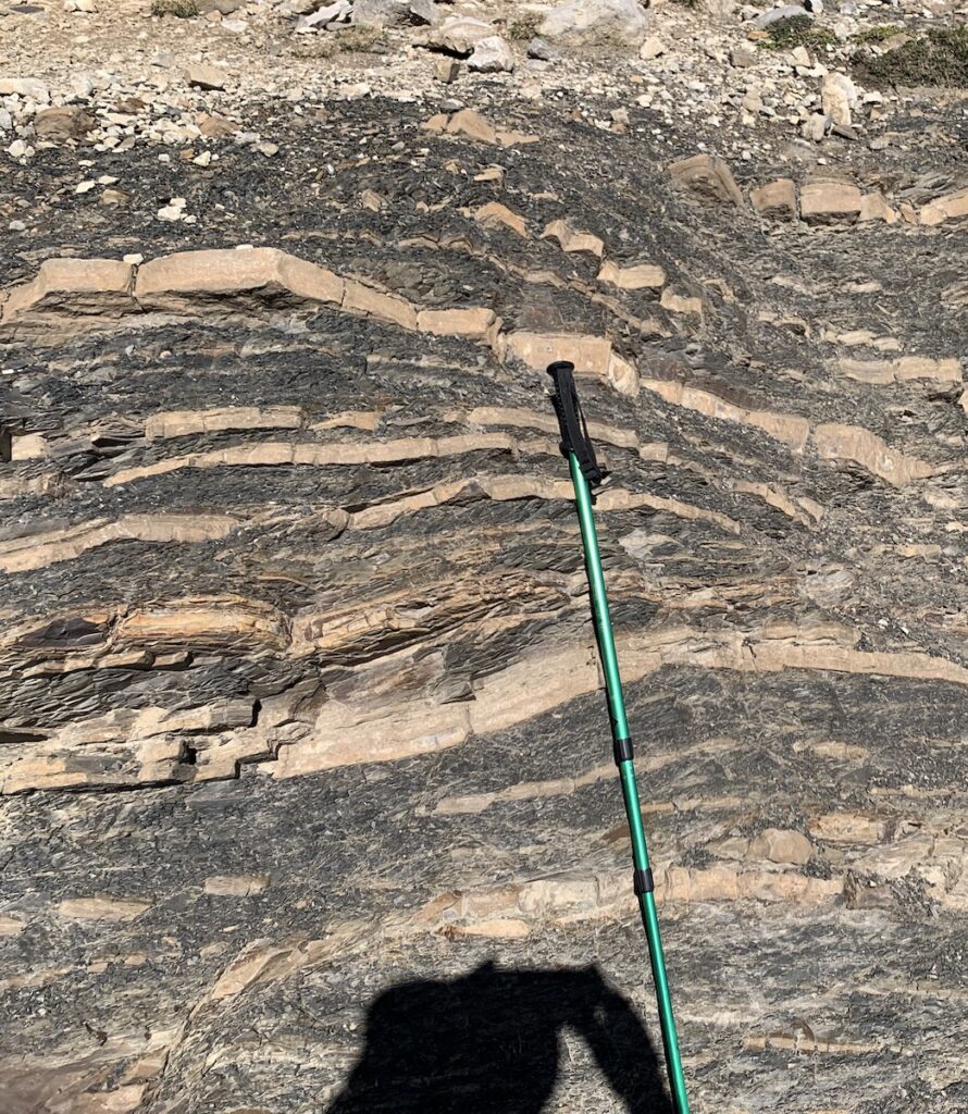
The oldest rocks in the national park are found west of Sotres. They were deposited in the ocean (step 1 in diagrams above) during the Cambrian Period (~540–500 Ma). The rocks are mudstone and sandstone that have been highly deformed by the collisional events that followed. Very little of these older rocks are preserved. Michael for scale.View looking northward into the Central Massif. The grey rocks at the top are limestones that formed as carbonate reefs in the Carboniferous (~325 Ma) when Spain was located in tropical latitudes. Sediments were deposited in a narrow ocean between the colliding plates of Gondwana and Laurentia (see 356 Ma paleo-map above). The base of the limestone is a thrust fault overlying sandstone and mudstone layers formed around the same time (step 3 in diagrams above). Nanci and Jay are hiking our route on Day 4 between Posada de Valdeón and Fuente De.These thrust faults are in the sandstone and mudstone part of Los Picos (Western Massif), where the structure is easier to discern. The thrust faults caused the rock sequences to tilt northward (left side of photo) while the sequences were being thrust southward (right side). This relationship is shown in step 5 in the diagrams above, where south is also to the right and north is to the left.Left-side photo: limestone (grey color) separated by a thrust fault from underlying inter-layered mudstone and sandstone. Right-side photo: close up of mudstone (sediments that settled from suspension in the ocean) and sandstone (turbidity current deposits in the ocean).For an explanation of turbidity currents, see my post from the Basque Geopark: https://landscapes-revealed.net/a-tour-through-the-basque-geopark-flysch/. This location is above Fuente De on the south side of the Central Massif.Folded layers of sandstone turbidites and thin inter-layered mudstone in the town of Espinama near Fuente De. This is what happens to sedimentary layers when they get caught up in continental collisions! The scales are Nanci, Michael, and me.
Other geological processes
A westward view from the Eastern Massif over the town of Sotres toward a valley in the Central Massif. The diagram below explains how this valley formed; the photo below is a closeup in the valley.Left-side diagram: (1) Discordant Permian sediments deposited on the paleo-relief of the limestone rocks previously deformed during the Variscan Orogeny (see step 6 in diagrams above). (2) Subsequent movement on two faults creates the down-dropped valley. (3) Erosion removes Permian sediments except those in the valley. Diagram is from reference listed below. Right-side photo: Permian “red bed” sediments deposited in a river. This photo was taken in the valley illustrated in the adjacent diagram and in the photo above. The famous Naranjo de Bulnes (Pico Urriellu) is the squarish peak directly above Michael.An extremely important process in Los Picos today is dissolution of limestone to create features called karst. As explained in other recent posts, limestone is where most caves form because calcium carbonate is easily dissolved if water is even weakly acidic. Left-side diagram: Los Picos are like swiss cheese because of the internal dissolution of limestone that has created a huge network of caves. This diagram shows the openings in one cave that extend 1441 m (4726 ft) below the land surface. Diagram is from the reference listed below. Right-side photo: We were not able to see the underground caves, but we could see surface effects of dissolution. Here are limestone rocks with vertical rills dissolved by downward-flowing water.
One might ask: why are Los Picos de Europa higher than the adjacent Cantabrian Mountains? It’s all about the limestone. With sandstone and mudstone, weathering processes are at the surface where erosion lowers the surface elevation. Limestone, however, has internal weathering processes that retain the surface elevation while dissolving the rock underground. Glaciers, though, have shaped even the limestone’s surface during the recent past.
An important recent process is the action of glaciers, since Earth has been in an Ice Age during the past 2 million years. We are currently in an interglacial (warmer) period, and with additional human-enduced warming, the glaciers are disappearing fast. A few remain in the highest elevations of Los Picos, but even at lower elevations the features formed when the glaciers were larger are readily visible. This photo shows a cirque in the Central Massif above Fuente De. The glacier that occupied this bowl-shaped depression has since melted.Left-side photo: This valley west of Fuente De, on our path toward Sotres, is a valley carved by glaciers during the Last Glacial Maximum 20,000 years ago. The ridges on either side of the valley are moraines—piles of sediments eroded from the mountains and then carried downhill as the glaciers advanced. These moraines are called lateral moraines because they formed along the sides of the glacier. Right-side photo: Closeup of the moraine on the left side of the other photo. The lone rock on the crest of the moraine (just right of Jay) is an erratic—a huge rock carried in the ice and then dropped on the ridge as the ice melted.
Human interference
Los Picos are now in a national park and are mainly used for recreational purposes. However, during the 19th and 20th centuries, the area was highly disturbed by mining activities, evidence of which can still be seen today.
On a day hike from Sotres, we saw tailings piles and other remnants of the Ándara mine that operated between 1860 and 1975. Their main objective was to recover zinc. Notice the ore cart on the right side of the photo that is next to one of the mine openings. Although a town served the workers in the mine, today the only remaining building is a small refugio (upper left corner of photo). Michael for scale.This photo from the Mirador del Cable above Fuente De (buildings in valley) show many of the elements discussed in this post. The treed slopes are the sandstone and mudstone deposits that erode more readily at the surface and support more vegetative cover. Limestone rocks make up the steep cliffs. It is difficult to see the thrust faults, but easy to see the folding in the distant Caliza de Panda (limestone of Panda). This synclinal fold formed because of compression during the collisional events. The closer limestone peaks were eroded by glaciers, and the hairpin path going up the slope toward the highest peak is an old mining road that is still used by some hikers.
In my next post, I’ll describe the 10-day trek we completed in El Parque Nacional de Los Picos de Europa. It will show the locations of places mentioned in this post.