Clearly, I did not find time to post any more blogs during our travels in northern Spain. The upcoming posts will follow a geologic time scale—from younger to older—rather than the chronology of our travels. This post focuses on a sequence of sedimentary rocks that were deposited between 110 and 50 million years ago, during the Cretaceous and Paleogene Periods. Incredibly, visitors can view this entire 60 million years of Earth’s history along a mere 20-km-long (12-mile-long) stretch of coastline.
About the Basque Coast Geopark
In 2010 the Basque Coast Geopark was added to the European Geopark Network. In 2015, it was declared a UNESCO Global Geopark, a designation that highlights the importance of geological sites and landscapes of exceptional value. I was able to plan our visit because of extensive online resources. This web site contains detailed information, including downloadable guides for driving or hiking (we hiked): https://geoparkea.eus/en/.
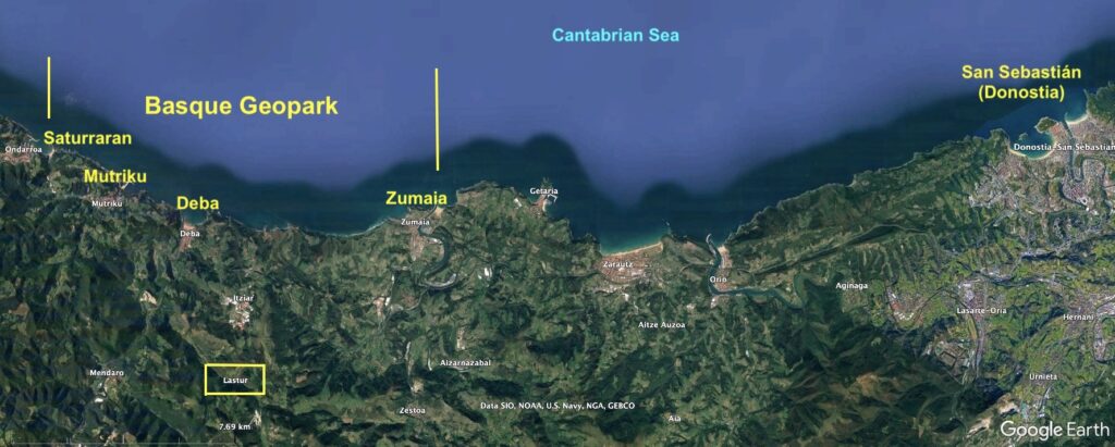
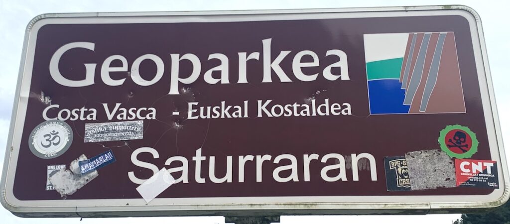
The Basque Geopark extends for 20 km between Saturraran Beach and Zumaia. The Geopark is located 38 km (23 miles) west of San Sebastián (Donostia in Euskara—the Basque language), and 70 km (42 miles) east of Bilbao. This part of Spain is on the Cantabrian Sea, the southeast corner of the Bay of Biscay that, to the northwest, opens to the North Atlantic Ocean. The mountains that parallel the coast are the Cantabrian Mountains that are the western extension of the Pyrenees Mountains between Spain and France.Because the Geopark is located in Basque Country, all signs are in Basque and Spanish. This sign, at the entrance to Saturraran Beach at the western end of the park, has the Basque word for geopark, and shows how different Euskara is from Spanish. Costa Vasca (Basque Coast) is Euskal Kostaldea in Euskara. [The graffiti is in Euskara, Spanish, and English!] The graphic in the upper right well illustrates the geology of the park: near-vertical cliffs of rocks along the sea, with adjacent green hills.The orientation of the layers is easy to see from offshore. We took a boat tour from Zumaia that traveled westward along the coast. All of the layers in the Geopark are tilted toward the east (left side of photo; our view is southward). Imagine rotating these layers back to horizontal, like they were when the sediments were deposited. The layers on the right would then be on the bottom (oldest layers) and the layers on the left would be on the top (youngest layers). Because the layers have since been uplifted and tilted, it’s possible to journey through 60 million years of time by traversing the sequence from west to east. These rocks at Zumaia are at the eastern end of the Geopark; they are thus the youngest part of the sequence. There are many interesting features in these layers that I’ll refer to later.
Where were these sediments deposited 110 million years ago (110 Ma)?
The Iberian Peninsula (Spain and Portugal) was a small tectonic plate located much closer to North America (Laurasia on map A) 100 Ma. The continents had all collided to form Pangea around 250 Ma, and by 100 Ma, the continents were moving apart again. The North Atlantic had been opening for millions of years and the South Atlantic had just began to open. As part of the rearranging continents, the Iberian plate rotated counterclockwise relative to the Eurasian plate and opened a basin that was a precursor to Biscay Bay (map B). This figure is from a research article by Andrieu et al. (Earth Sciences Bulletin 2021, v. 192). Their “study area” (red box) was in the Pyrenees Mountains that extend eastward from the Basque Geopark and have a similar history. Although it may not look like it in the map above, Spain was then in tropical latitudes, where calcareous reefs abounded. The areas labelled “1” in this 3-D image are carbonate platforms formed in shallow water. The area labelled “2” are the sediments that were deposited in a deep ocean and that are now exposed along the coast of the Geopark. The dark blue area between Spain and Eurasia on Map B above is the ancient ocean basin. This image is from the Geopark’s web site: https://geoparkea.eus/en/. This view is southward from a coastal trail in the Geopark toward inland mountains that are ancient carbonate platforms built up by reef-forming rudists and corals. Refer to the 3-D image above and then return to this photo. Imagine that sea level was at the height of the mountaintops and that land was even farther to the south. At our position at the coast, we would have been up to 2000 m (6500 ft) below sea level (position “2” on image above). So if you want to see the deep-water sediments, you need to travel along the coast, but if you want to see the carbonate reefs, you need to go up into the mountains. Left-side photo: Although we did not visit the inland Basque mountains, we did see some rocks that had been quarried there. These stone blocks on the coastal promenade at Deba (see location on map at top of page) were quarried in a nearby mountain quarry (yellow box on map). These fossils are rudists that, together with corals and other organisms, were the major reef builders during the Mesozoic Era.
Right-side photo: This photo of fossil rudists in 3-D gives a better idea of their appearance. These odd organisms look like corals but they were actually bivalves related to today’s clams and oysters. Their name is from the Latin word rudus meaning rubble or broken stone. Rudists were incredibly diverse; according to this web site (https://www.paleotax.de/rudists/intro.htm), there were about 200 genera and thousands of species. The entire group went extinct during the Cretaceous-Paleogene (K-Pg) mass extinction event, an event I’ll come back to later since it is recorded in the sedimentary layers of the Geopark. The photo is from a Jamaican web site (https://www.fossilcoastdrinks.com/post/jamaica-s-fossil-rudist-bivalve-assemblages-from-the-late-cretaceous).While on the subject of fossils, here are two more specimens from the Geopark. Left side: a huge ammonite—a diverse group of cephalopods abundant during the Mesozoic Era but that, like the rudists, went extinct during the Cretaceous-Paleogene (K-Pg) mass extinction event. Right side: a crazy-looking belemnite, another common Mesozoic cephalopod, displayed here swimming with ammonites. This group managed to survive the K-Pg extinction, but disappeared soon afterward. Both fossils are from the small Nautilus Geology Museum in Mutriku (see map at top of page) that has a wondereful display of ammonites and belemnites collected from nearby coastal sedimentary rocks. The specimens are all original fossils, not replicas.
What happened since these sediments were deposited?
Obviously, if these sediments were deposited as flat-lying layers in a shallow to deep ocean basin, something dramatic must have happened since then.
Left side diagram: The map shows the configuration of the Iberian Peninsula during the Cretaceous Period when the Iberian plate was rotating counterclockwise (red arrow) and an ocean basin was forming between Iberia and Eurasia (red dot). The bottom image shows how normal faults were accommodating the process of extension—the black arrows show how blocks drop downward as extension pulls the crust apart to create deep basins. This process continued into the Cenozoic Era until the tectonic plates converged and layers were compressed.
Right-side diagram: Look at Map A above (what the continents looked like 100 Ma). Notice the Tethys Ocean that was located between Africa and Eurasia. As the continents moved apart, the Atlantic Ocean widened and the Tethys Ocean closed. At the beginning of the Cenozoic Era (66 Ma), Africa began colliding with Eurasia. This event, which created all of the Alps, is called the Alpine Orogeny (i.e., mountain-building event). The Iberian Peninsula was caught in this crunch and about 40 million years ago, the Peninsula collided with Eurasia to create the Cantabrian-Pyrenees mountains. During the Alpine-Pyrenean Orogeny, the formerly active normal faults were inverted; that is, they were reactivated with the opposite sense of motion to become thrust faults, as shown in the 3-D image. The thrust faults have folded and uplifted the deep-ocean rocks to where we can see them today. The inset map shows the configuration of Iberia during the Alpine-Pyrenean Orogeny that continued until about 10 Ma. The red dot is the location of the Geopark today. Both diagrams are from the park’s web site: https://geoparkea.eus/en/. The entire sedimentary sequence exposed in the Basque Coastal Geopark is called a monocline because all of the layers are tilting in the same direction. The other side of the fold—where layers tilt in the opposite direction—is probably offshore and largely eroded. This piece of the sequence—located below the Hermitage of San Telmo in Zumaia—shows effects of the Alpine-Pyrenean Orogeny. All of the layers are tilted to a near-vertical orientation and under the hermitage you may be able to see small-scale folds and faults. All of this deformation is the result of the collision between the Iberian and Eurasian tectonic plates—part of the larger-scale Africa-Eurasia collision.
Processes at the Geopark today
Today, ocean waves, wind and rain continuously shape and alter the coastal landscape. Tides are also important, particularly when choosing a time to visit the Geopark. The tidal range (vertical distance between high tide and low tide levels) is large along this coast—ranging from 2 m (6.5 ft) to 4 m (13 ft). Fortunately, tidal data are available in advance, so I chose four days when a large tidal range produced particularly low tides during daylight hours. This is when rock viewing is at its best!
This photo, taken during low tide at Sakoneta Beach (between Deba and Zumaia—see map above) shows why you want to visit during a very low tidal level. The wave-cut platform is a dynamic feature that is commonly observed along cliffed coastlines, including along much of the U.S. west coast. Hopefully you can see that the layers are continuous between the flat platform and the cliff. The continual onslaught of breaking waves (not too evident on this calm September day!) wears away at the cliff and expands the wave-cut platform. This causes cliff retreat and bodes poorly for anyone foolish enough to build their home too close to the edge. Here is a view of the wave-cut platform from sea level. The shoreline angle is the angle between the wall of the cliff and the platform (upper part of photo). This is where the erosive action is concentrated. The waves work there to undercut the cliff, which causes the overlying layers to come tumbling down. On a calm sunny day at low tide, though, the platform is a good place for lunch. Jay is showing off his Cantabrian wild-boar sausage and goat cheese.Because waves undercut the cliffs, it is not surprising that coastal landslides are common along this coastline. Although we walked on the coastal trail at the top of this landslide, we could not see it until we went on a boat tour along the coast. This section is mostly weak mudstone that is highly susceptible to sliding. The lower 2/3rds of this cliff face is a jumble of fallen and rotated layers. The toe of the landslide reaches out into the sea, where waves continually remove it to cause even more sliding.
My next post will show more details of this incredible sedimentary sequence.
Thanks to you, I now know there is such a thing as a geopark! And since they exist, I’m not surprised to find you visiting one.
Landscapes Revealedon October 3, 2023 at 9:10 pm
Europe rocks! There are currently 94 Geoparks in 28 European countries. Spain has quite a few and more are “aspiring”. The Costa Quebrada is a section of coast we visited around Santander, located west of Bilbao. They already have lots of signage and aspire to be part of the European system that I imagine brings significant resources for further tourist development.
Keeley Kirkendallon October 5, 2023 at 10:02 am
Thanks. I wish I had this knowledge 15 years ago when I was in the area.
Landscapes Revealedon October 5, 2023 at 11:25 am
I suspect there is now a lot more information available from the park itself. You visited just before it became part of the European Geopark system in 2010.
After hearing about your trip to, and discussing this Geopark, super interesting! I believe we saw monoclines walking in San Sebastian’s Coche Bay (at the end) ?!?
Landscapes Revealedon October 6, 2023 at 9:24 am
I assume you mean La Concha Bay—you get an A+! Indeed, all of the layers we saw are tilted toward the NW in a monocline. But like most monoclines, there is another side somewhere. I took a photo of a geology map when we hiked eastward to San Pedro/Pasai (can’t seem to attach photos in my reply). It shows the axis of a large-scale anticline, and to the south of San Sebastian layers are tilted in the opposite direction—to the SE. But we couldn’t see that part!
Lynnon October 7, 2023 at 7:26 am
Yep… ConchA! Thanks for the geology map. Look forward to more details in your next post.


Thanks to you, I now know there is such a thing as a geopark! And since they exist, I’m not surprised to find you visiting one.
Europe rocks! There are currently 94 Geoparks in 28 European countries. Spain has quite a few and more are “aspiring”. The Costa Quebrada is a section of coast we visited around Santander, located west of Bilbao. They already have lots of signage and aspire to be part of the European system that I imagine brings significant resources for further tourist development.
Thanks. I wish I had this knowledge 15 years ago when I was in the area.
I suspect there is now a lot more information available from the park itself. You visited just before it became part of the European Geopark system in 2010.
After hearing about your trip to, and discussing this Geopark, super interesting! I believe we saw monoclines walking in San Sebastian’s Coche Bay (at the end) ?!?
I assume you mean La Concha Bay—you get an A+! Indeed, all of the layers we saw are tilted toward the NW in a monocline. But like most monoclines, there is another side somewhere. I took a photo of a geology map when we hiked eastward to San Pedro/Pasai (can’t seem to attach photos in my reply). It shows the axis of a large-scale anticline, and to the south of San Sebastian layers are tilted in the opposite direction—to the SE. But we couldn’t see that part!
Yep… ConchA! Thanks for the geology map. Look forward to more details in your next post.