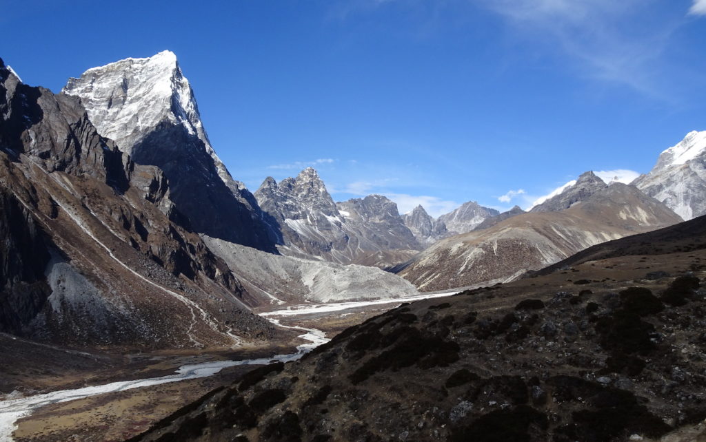
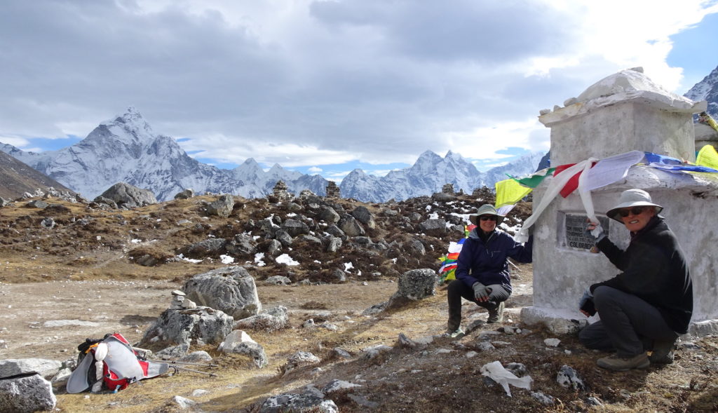
Jay and I opted to take the valley route, because we had promised a friend at home that we would try to find the memorial for his hiking buddy who lost his life in the 2015 earthquake. This northward view shows the beautiful valley we hiked along. The snowy peak on the left is Taboche (again—we kept circling around it!), with the Taboche glacier debouching from the peak into the valley (see closer view of this glacier below, on day 14). We continued along the valley to the right (northward), where we found the memorial site. Several days later we would head westward, crossing the lower brown hills and a pass through the mountains on the ridge in the center of the photo (see closer view of this ridge below), on our way to Goyko.Jay and I found the memorial for our friend’s hiking buddy (Tom) in the midst of a large group of memorials to people who had perished, for various reasons, in their attempt to climb Mt. Everest. We carried strings of prayer flags and tied them across the memorial as a dedication to someone who tragically lost his life in these beautiful mountains. Other memorials are visible along the top of the moraine ridge between us and the snowy peaks in the distance. This was an emotional scene.
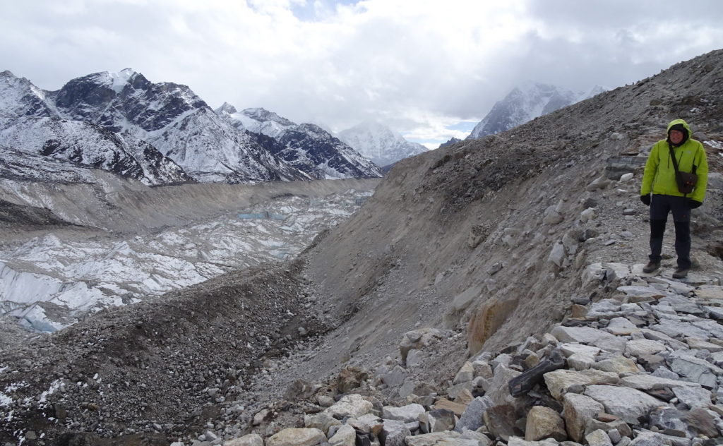
Tom, whose memorial we visited, was at Everest Base Camp on 25 April 2015 to document life in the camp, where climbers waited, often for weeks, for favorable weather conditions. The snow avalanche produced by the 2015 earthquake (7.8 magnitude) killed 15 people at Base Camp, and injured many more. The danger came, not because the camp got buried by snow, but because a “hurricane-force wind blast”, generated when the ice in the avalanche fell, blew a wide swath through camp that hurled people to their death (https://www.outsideonline.com/outdoor-adventure/exploration-survival/everest-base-camp-avalanche-study-nepal-earthquake/). More than 1000 climbers were in or near Base Camp during the earthquake. The clouds gathering on day 11 (see memorial site above) heralded our weather for the next 2 days, after our night in Lobuche. On day 12, we hiked northward up the valley occupied by the Khumbu glacier toward Gorak Shep and Everest Base Camp. This southward view across the glacier is back down the valley toward Lobuche. Jay is standing on the Khumbu glacier’s westside lateral moraine; the eastside moraine is visible on the other side of the valley. Not long ago, the glacier would have filled the valley to the level where Jay is standing. But the Khumbu glacier, like all of the glaciers in the Himalayas, is shrinking rapidly. Jay looks cold because it was—wouldn’t you know that the only 2 cloudy days of the trek were the days when we were closest to Mt. Everest! And there is Everest Base Camp—it’s the snowy area at the upper end of the valley on the photo’s right side. Mt. Everest is farther to the right, but hidden in clouds. The Khumbu ice fall—lowest part of the route to the summit—flows down from the right to the top of the Khumbu glacier. Climbing expeditions pitch their tents on loose rocks of the moraine adjacent to the glacier, where they await favorable weather conditions. In May, trekkers would see many brightly colored tents at the top of this valley, but in November there was nothing but rock and ice.
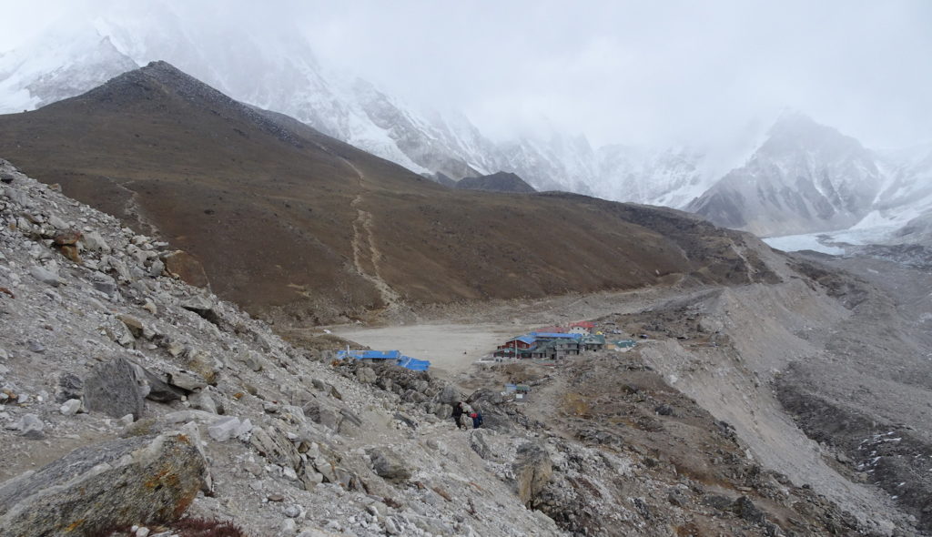
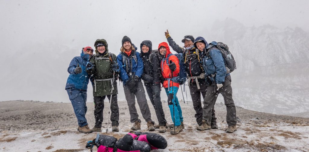
The settlement of Gorak Shep is located on an old lake bed; it is a forlorn outpost, especially in cloudy weather. At 5160 m (16,925 ft), it was the highest place we slept (day 12), and the lodge (blue roofs on the left) was the most basic, least comfortable we experienced. That brown “hill” is Kala Patthar, which like Chhukhung Ri is dwarfed by the adjacent giants although its summit is at an impressive 5550 m (18,204 ft) elevation. The next day we headed up that path, in an attempt to reach the summit of Kala Patthar, with its (alleged) best views of Everest. And here is part of our group on the path up Kala Patthar the next day, after we succumbed to the weather and prepared to descend because the weather was deteriorating and visibility was greatly reduced. Despite not seeing Mt. Everest, we were happy because the light snow was delightful and we knew we’d have other opportunities to see Earth’s highest mountain. Photo courtesy of Rebecca Douglass, fellow trekker who used her camera’s self-timer feature. Back we went—down the valley along the Khumbu glacier to stay in Lobuche another night (day 13).
A note about melting in the Everest region: Glaciologists recently recovered the highest ice core ever drilled—at 8020 m (26,300 ft)—on the South Col Glacier that is the highest glacier on Mt. Everest. They discovered that this glacier has lost 2000 years of snow and ice accumulation in just 30 years (since the 1990s), threatening the experience for those attempting to ascend Mt. Everest. Snow and ice removal exposes bedrock at high elevations, ice block movement and avalanches make the Khumbu icefall more treacherous, and melting on the glacier lowers and destabilizes Everest Base Camp that is home to ~1000 climbers and logistics teams during the climbing season. For more information, see https://www.nature.com/articles/s41612-022-00230-0.
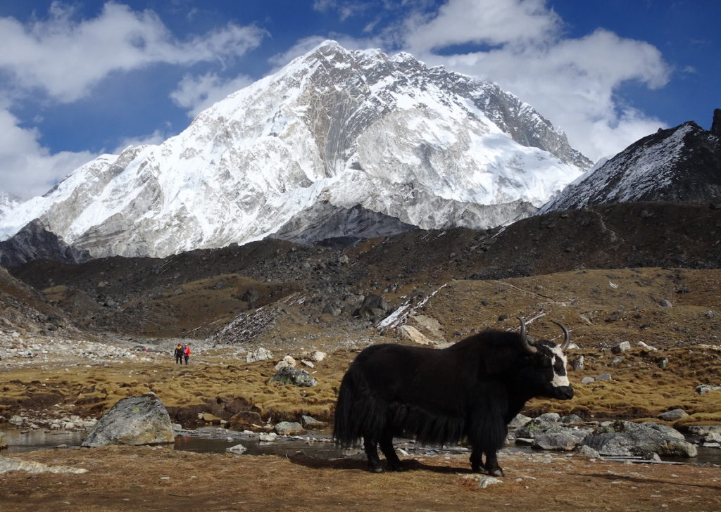
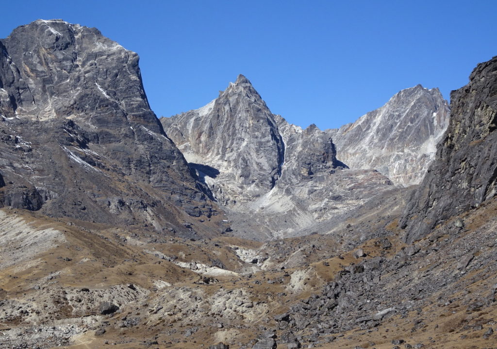
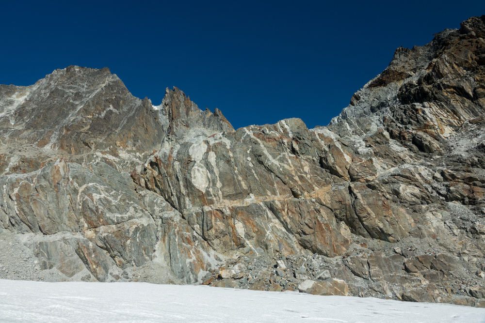
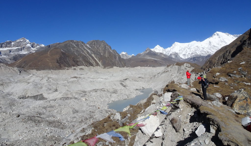
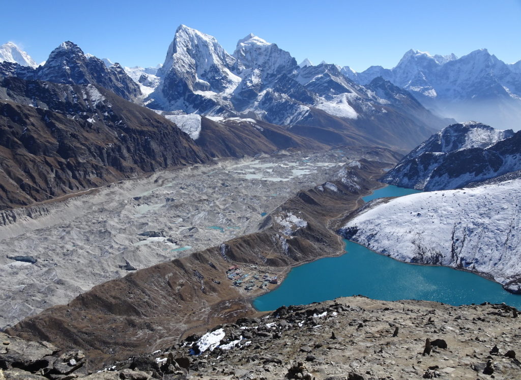
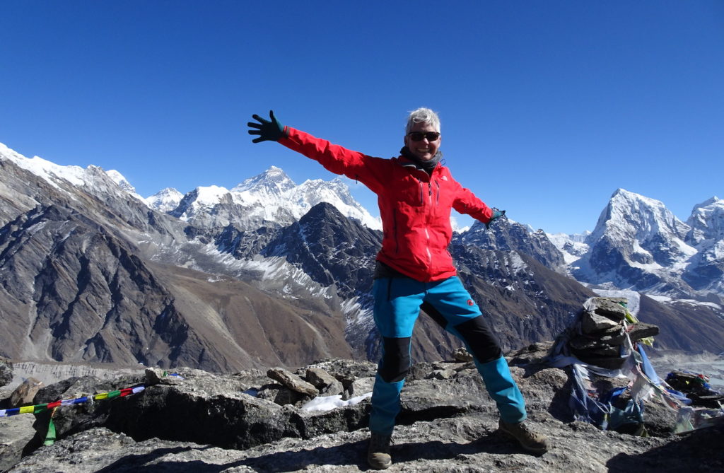
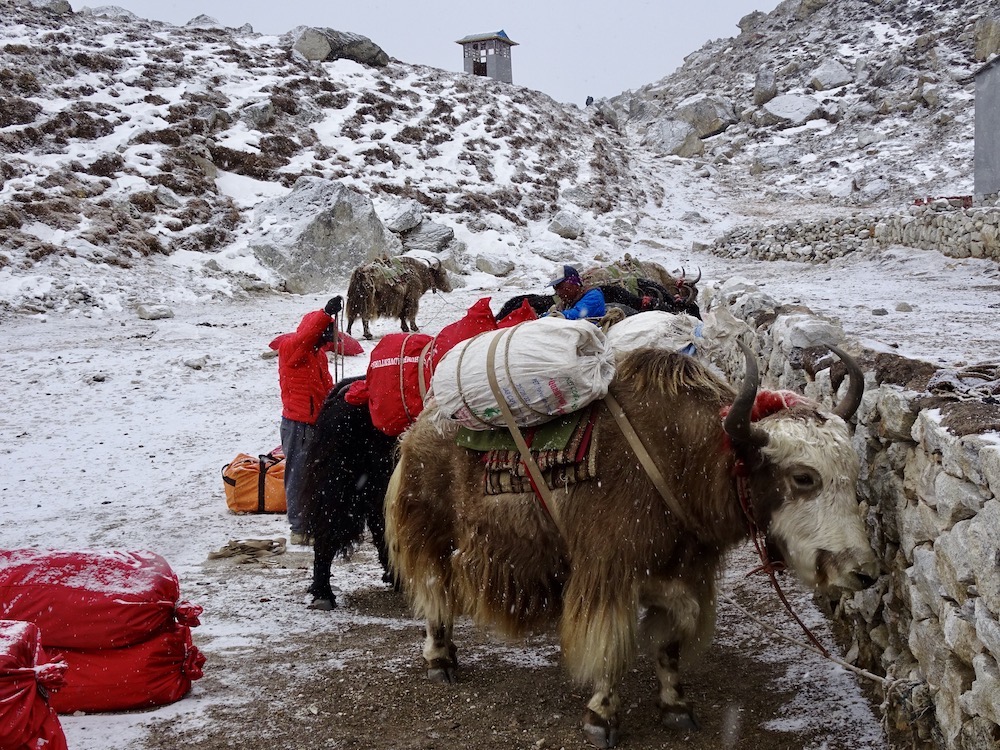
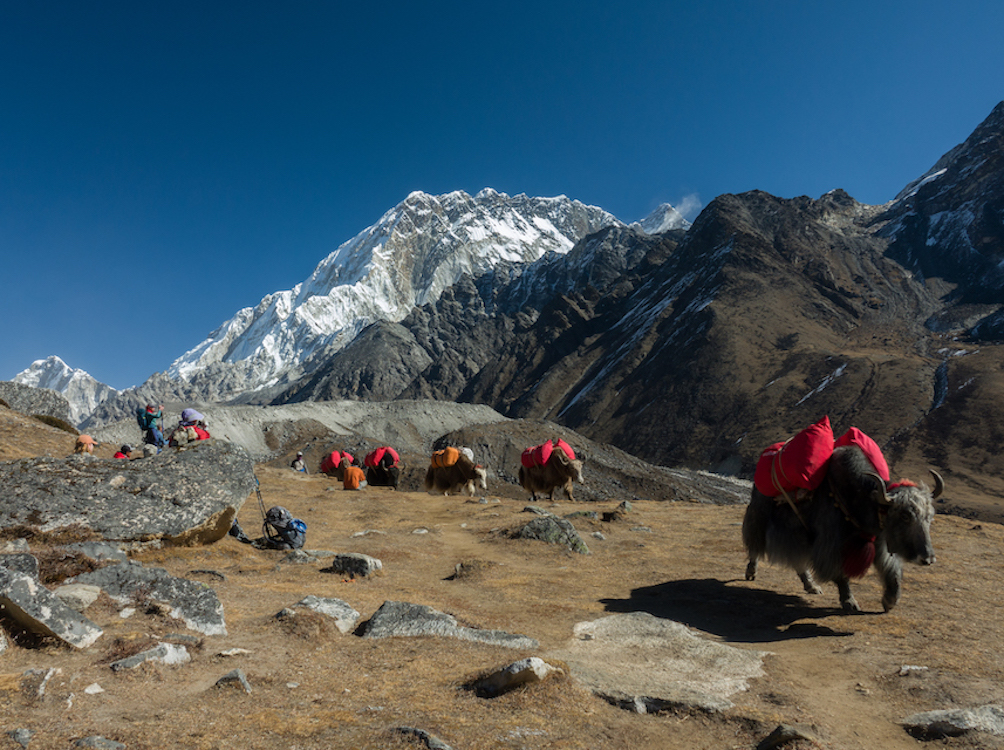
View of Nuptse peak (7,861 m / 25,791 ft) from near our lodge in Lobuche, with yak and trekkers in the foreground, and a lateral moraine of the Khumbu glacier between the trekkers and Nuptse. Note the white rock (leucogranite) on either side of a rib of dark metamorphosed sedimentary rocks (gneiss). The “ballooning” shape of the leucogranite indicates it was molten as it pushed upward and intruded into the meta-sedimentary rocks. It is an extraordinary exposure of igneous rock that, when molten, intruded into and displaced the older pre-existing rock. Toward the end of day 13, the sky began to clear, heralding the clear weather we’d have for the duration of the trek.Day 14 took us from Lobuche to Dzongla along a beautiful valley with stellar views of Ghola Tsho (lake), here shown with the Taboche glacier flowing downhill from Taboche peak. Note the lateral moraines on each side of the glacier, which is covered with loose rocks eroded by the glacier from Taboche peak. Glacial lakes, such as Ghola Tsho, have this beautiful turquoise color because ground-up flour-sized rock particles remain suspended in the water column. Sunlight reflects off of the particles to give the lakes their color. The lodge at Dzongla is hidden in the crevices of the low hills in the valley above Ghola Tsho. From Dzongla (day 15), the group crossed the Cho La (pass), located between the “shark fin” peak in the center of the ridge in this photo and the peak just behind it. Metamorphic rocks along this pass have spectacular patterns indicating their complex geologic history. This photo (courtesy of Kim Bannister, our guide) demonstrates some of the geologic history. The rock is gneiss—a metamorphosed sedimentary rock that probably originated as mudstone. The white “blobs” that look like beads on a chain are more competent (i.e., stronger) components that were pulled apart within the weaker components of the gneiss—imagine stretching the layers up into the air to cause the “layer” to separate. This feature is called “boudinage” (boudin=sausage in French) because it looks like sausage links. The vertical “layering” in the gneiss is a remnant of original sedimentary layering and/or separation of components during metamorphism, as the rocks were pushed deep beneath Earth’s surface. Horizontal stripes cut across the vertical pattern, indicating the later intrusion of molten rock to form these granitic veins. Swirling patterns within the gneiss show the rocks were soft enough to flow. This happens at depth where temperatures are hot. Then, the rocks were lifted back up to the surface, and we can now puzzle out their history!From the tiny settlement of Tangnak, in the valley west of Cho La, we proceeded farther west (day 16) across the Ngozumpa Glacier to Goyko, a settlement we reached as soon as we crossed the Ngozumpa Glacier’s westside moraine. A trail is visible on the slope of a brown hill (closest hill on other side of the glacier) that is Goyko Ri (peak). On day 17, we climbed to the summit of this peak (5357 m / 17,570 ft), where we had our first clear views of Mt. Everest. Crossing the Ngozumpa Glacier was challenging because we had to climb down and back up the steep edges of the valley and because the glacier itself created a rugged terrain with many ups and downs. Although it may look like the valley is filled only with rocks, there is still some ice underneath the rocks, but the glacier is shrinking rapidly and will continue to become more difficult to cross. View south from high on the slope of Goyko Ri, overlooking the settlement of Goyko, Goyko Lake, and the Ngozumpa Glacier we crossed to get to Goyko (where we stayed 2 nights). The 2 snowy peaks in the center of the photo are Taboche (right-most) and Cholatse (left-most). The summit of Goyko Ri (5357 m / 17,570 ft) provided jaw-dropping views of Mt. Everest (underneath my right hand) and adjacent peaks, Nuptse and Llotse (to the right of Everest, under my arm). That’s Taboche and Cholatse again, at the right edge of the photo. What an exhilarating feeling to be at this high elevation, staring at some of Earth’s highest peaks.I’ll end this post with 2 photos of our steady porters—8 yaks that carried our gear every day. Left-side photo: the staff packing our gear on the yaks at Gorak Shep. Right-side photo (courtesy of Kim Bannister, our guide): yaks carrying our gear (two duffel bags per yak) on the trek between Lobuche and Dzongla. The snowy peak in the background is Nuptse.
In the next post, we’ll continue west and south from Goyko, back to Lukla. There will be more spectacular views of Everest from the Renjo La (pass) west of Goyko.
Landscapes Revealedon February 15, 2022 at 11:47 am
We were surprised by the emotion that arose, even though we did not know Tom personally.
Rebecca Douglasson February 15, 2022 at 9:37 pm
Great stuff! I need to re-read these and get some of that info into my slide show!
Landscapes Revealedon February 16, 2022 at 9:01 am
Excellent!
John H Pennyon February 17, 2022 at 12:57 pm
Another fantastic post, and stunning view of the roof of the world!
Curious if you happen to know how far your hand was from the summit of Everest (as crow flies, gasping for oxygen…)
Landscapes Revealedon February 20, 2022 at 2:48 pm
Good question John! According to the map, my hand was 95 km (57 miles) west of Everest, with an uphill slope from 5483 m to 8850 m (17,984 ft to 29,028 ft). That’s an angle of just 2 degrees, which is why Everest appears to be at a similar elevation, although it is 3367 m (11,044 ft) higher!


Amazing peaks. What an experience visiting Tom’s burial spot. So cool you did they and paid tribute with the decorations. ❤️
…did “that” …
We were surprised by the emotion that arose, even though we did not know Tom personally.
Great stuff! I need to re-read these and get some of that info into my slide show!
Excellent!
Another fantastic post, and stunning view of the roof of the world!
Curious if you happen to know how far your hand was from the summit of Everest (as crow flies, gasping for oxygen…)
Good question John! According to the map, my hand was 95 km (57 miles) west of Everest, with an uphill slope from 5483 m to 8850 m (17,984 ft to 29,028 ft). That’s an angle of just 2 degrees, which is why Everest appears to be at a similar elevation, although it is 3367 m (11,044 ft) higher!