During our trip to Chiapas in March (2024), we visited several Mayan ruins, including Palenque, considered to be one of the most impressive and mysterious of all Mexico’s ancient Maya sites. Please see my last post for map of Chiapas and location of Palenque: https://landscapes-revealed.net/the-beautiful-turquoise-blue-waters-of-chiapas-mexico/. In this post, I’ll describe some features of the Mayan sites and consider why these ancient cities collapsed more than 1000 years ago.
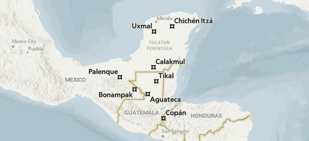
Many scholars believe Mayan civilization first coalesced between 7000–2000 B.C. after hunter-gatherers from South America moved into Mesoamerica and settled there. The urban centers, whose ruins we can visit today, were mostly built during the Classic period (A.D. 200-900). These soaring pyramids and other grand buildings were richly decorated with sacred art dedicated to the gods. Mayan civilization consisted of numerous, independent power centers unified by common languages, calendars, a system of writing, and various religious rituals and other customs. This map and the description are from National Geographic, 2023—see reference below. The map shows some of the major Mayan sites, including Palenque and Bonampak in Chiapas.
Palenque
Located in the northeast corner of Chiapas, Palenque is a major tourist draw. It is a UNESCO World Heritage site whose ruins lie in a tropical forest along the Usumacinta River. Its original name may have been Lakamha, a Mayan word related to rivers. Most people travel from San Cristobal de las Casas, located about 5 hours to the southwest of Palenque. Since we were on a counter-clockwise tour of eastern Chiapas, we approached from the southeast, from Bonampak (see map above). The city of Palenque provides tourist infrastructure with numerous hotels, restaurants, and guiding services.
Palenque reached its zenith during the 7th century A.D., when the city was transformed into a powerful Mayan capital under the reign of King Pakal the Great. Pakal had an amazingly long life for his time—he held power from 615 until his death in 683 at about 80 years of age. It was under the rule of Pakal and his son that most of the buildings visible today were constructed. The buildings, many filled with expressive bas-relief sculptures and inscriptions, have provided important clues about ancient Mayan beliefs. The inscriptions are hierglyphs—writings scholars can now interpret. Many describe the succession of rulers, called ajaws, who served as links between the gods and the people. Since Mayans believed the gods controlled the weather, it was the ajaw’s role to intercede with the gods to help protect and feed his people.
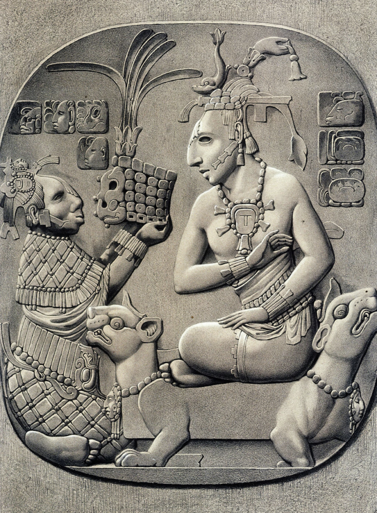
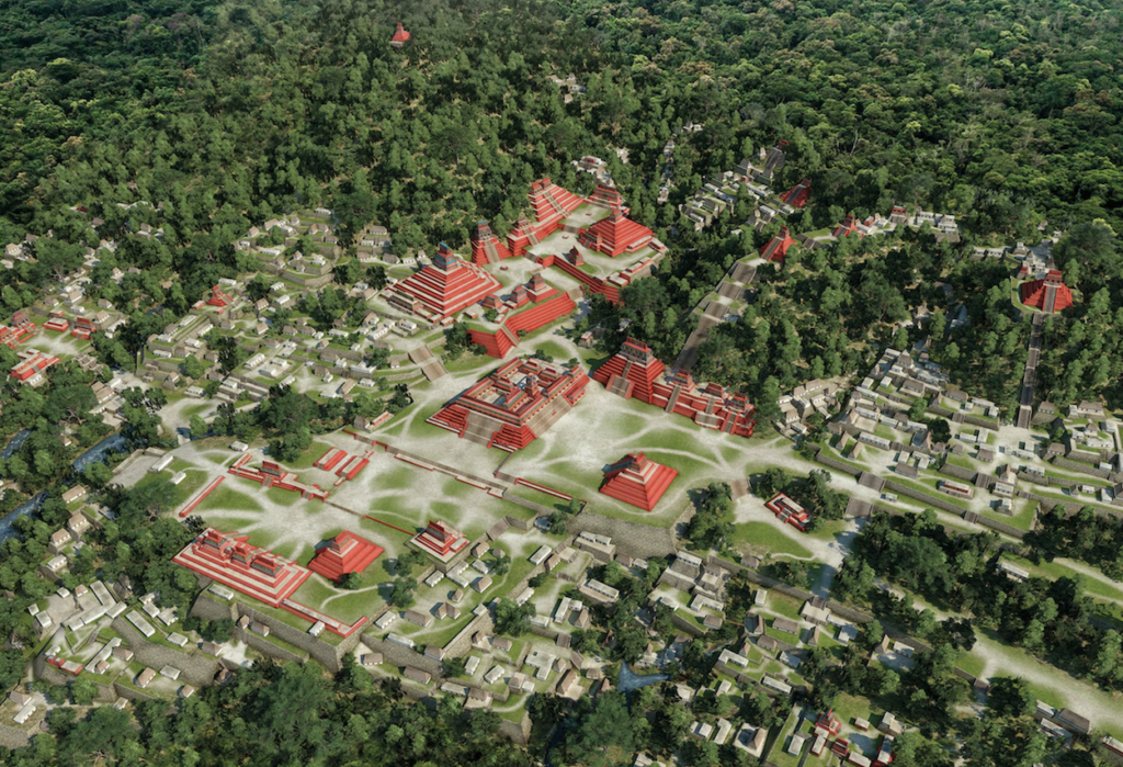
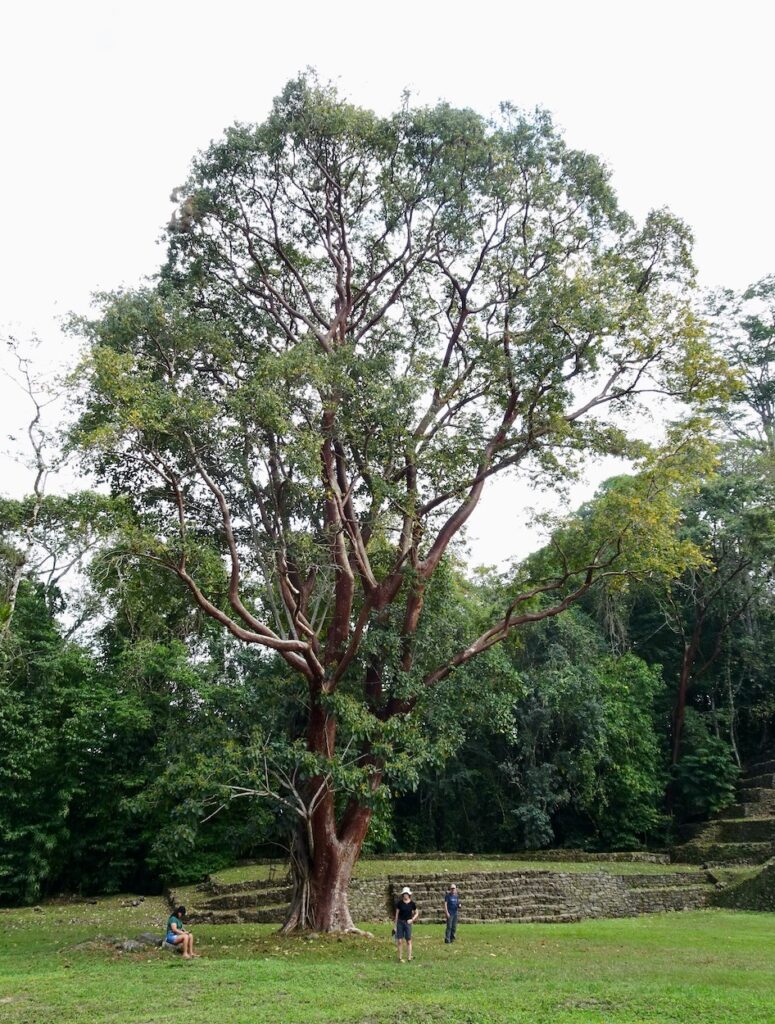
Our group in front of Palenque’s most notable structure—Temple of the Inscriptions—a 90-foot-high pyramid containing some of the most detailed Mayan hieroglyphic inscriptions ever found. These codices record the history of Palenque and its people, providing valuable insight into the culture, beliefs, rituals, and worldview of Palenque’s residents. Scholars thought the building was a religious center until 1952, when an archaeologist discovered the tomb of Pakal hidden below in a well-preserved chamber. This Information is from National Geographic, 2022—see reference below.Although it is not possible to see Pakal’s tomb in Palenque, it is possible to see a re-creation in the National Museum of Anthropology in Mexico City. The ruler was buried with a jade death mask and a large variety of valuable objects (left-side photo). Most amazing is the seven-ton sarcophagus lid that was made from a single piece of limestone (right-side photo). This carved lid is one of the great treasures of universal art. Most scholars agree that the central figure depicts Pakal transformed into the god of maize, fertility, and abundance. Behind him is the Maya World Tree—the ceiba tree (see photo below)—that Pakal is preparing to ascend. Around the edges of the lid are adornments representing the sky and celestial objects, and Pakal’s ancestors. Pakal evidently wanted to leave a record of the prosperity his dynasty had brought to the city. This information from National Geographic, 2022—see reference below.This view is of Pakal’s palace, a building whose tower was added by Pakal’s son. Also visible is the thick jungle that grew up after the city was abandoned by the end of the 8th century A.D. We had a Mayan guide who led us on a walk through some of the jungle surrounding the excavated buildings. He also showed us some of the work created by local artisans. This leather piece depicts the lid on Pakal’s tomb (see explanation above).These photos were taken on our walk through the Palenque jungle. Left-side photo. Samantha is hugging a ceiba tree, the sacred “World Tree” of the Mayan people. As the symbol of the universe, the roots are thought to reach down into the underworld, the trunk is the middle world where humans live, and the canopy of branches symbolizes the upper world and the thirteen levels of the Maya heaven. Right-side photo. Jay and I with a giant vine among other luxuriant plants.Left-side photo. Our group and Alejandro, our guide and driver for the eight-day tour of ruins and waterfalls (see link to previous post above). On our walk through the jungle, we saw parts of ruins still only partially excavated. Many more buildings remain totally buried beneath jungle vegetation. Right-side photo. In 1832 Jean-Frédéric Waldeck sketched this relief from Palenque depicting a seated ruler adorned with jewelry on a jaguar throne (from National Geographic, 2022).When Palenque was an active city filled with thousands of residents, the buildings were painted bright red, as shown in this depiction from the National Geographic, 2022, article (reference below). Red symbolizes life to the Mayans. Scribes carved the history of their civilization onto the walls in ornate hieroglyphs that were not deciphered for over a thousand years. Only a small percentage of the original buildings have, so far, been excavated.
Bonampak
On our clockwise route in the eastern part of Chiapas, we visited the ruin of Bonampak, located near the Guatemalen border, before continuing northwestward to Palenque (see map above). Although the site is small, it is important because it has some of the best preserved murals seen in any of the Mayan ruins. The buildings date from the late Classic period, from around 580 to 800 A.D. Bonampak has little tourist infrastructure and few visitors.
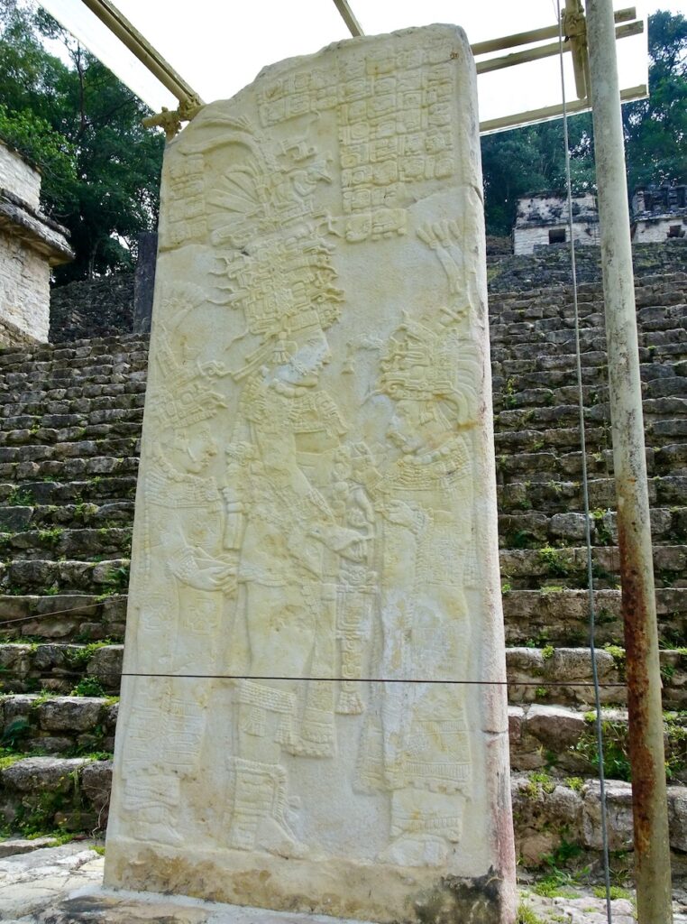
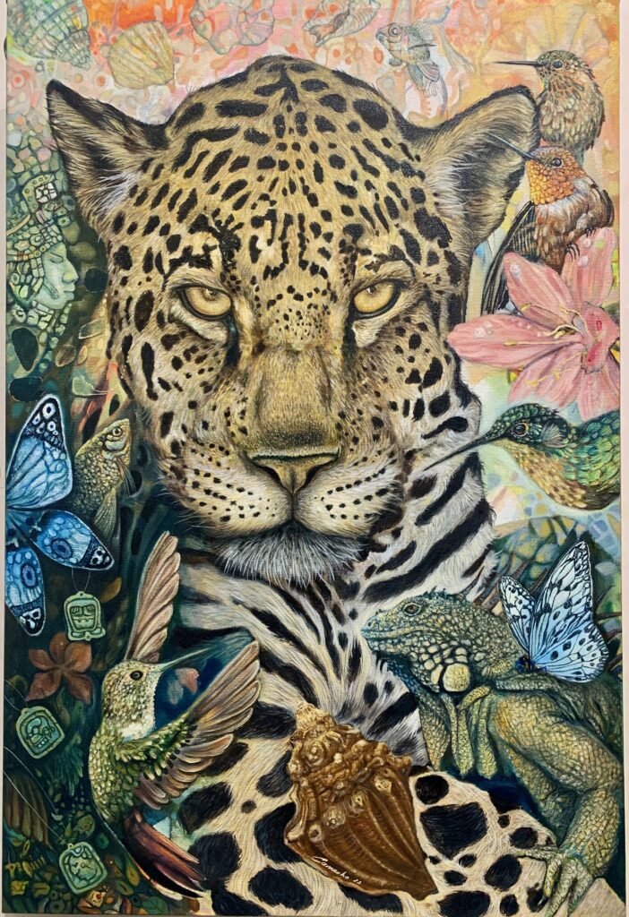
This panorama of the site shows temple buildings on the left and stellae in the open space below.Left-side photo. A stella showing the richly-dressed ruler Chan Muwan II (~800 A.D.) in the company of two women—his mother in front and his wife behind. The scene revolves around the ritual of self-sacrifice. Sacrifice of oneself and others was a common tactic to appease the gods. Right-side photo. Tree with beautiful cocoa-colored bark at Bonampak.The temples that housed the murals we viewed. The murals are incredibly detailed and hard to photograph because of low light and some color degradation. When the city was active, the exteriors of the buildings were also brightly colored.The murals have been re-created in Mexico City’s National Museum of Anthropology. This mural depicts the royal court during the ascension of one of Bonampak’s last rulers. Fortunately, experts have now been able to decode the hieroglyphics, which explain the unfolding event. A few of the murals lack commentary, probably because the city was collapsing.This mural is considered the greatest battle scene in all of Mayan art. The losers are being gripped by their hair and the victors wear jaguar headdresses and clothing items. The jaguar’s formidable size, reputation as a predator, and evolved capacities to survive in the jungle made it an animal to be revered. The Maya adopted the jaguar as an authoritative and martial symbol, and incorporated the animal into their mythology.
Yaxchilán
After Bonampak, we planned to visit Yaxchilan, an ancient city with close affinity to Bonampak. However, the site was closed due to unspecified “political conflict”. We were, however, able to see some pieces from Yaxchilán that were relocated into Mexico City’s National Museum of Anthropology.
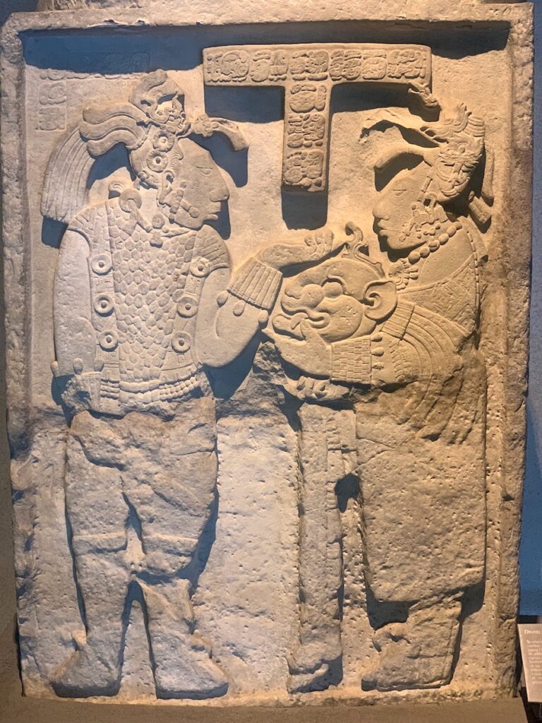
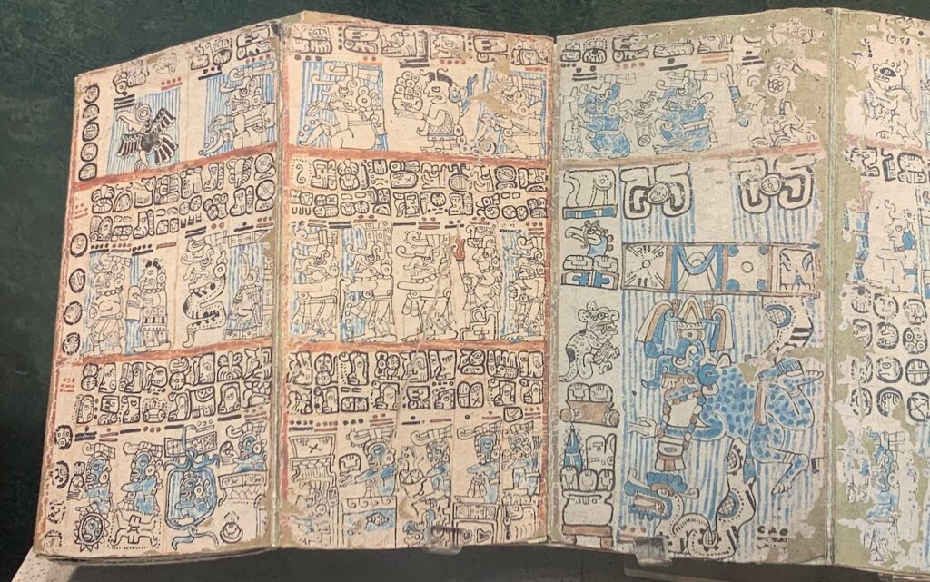
Left-side photo. This stella is part of a series that tell of the ruler Balam’s successes during his 46-year-long reign. Note the head of a jaquar—a power symbol. Right-side photo. This hierglyph carved in rock tells a story about the history of Yaxchilán, including names of some rulers. It contains the date of creation, corresponding to our date 13 of August in 3114 B.C., and the date when one of the rulers occupied the throne, corresponding to our date 11 of February in 526 A.D.The Mayans inscribed their writings into rock and also on paper as books, called codices. Unfortunately, when the Spanish colonizers arrived, they burned almost all of the books in their attempts to convert the indigenous people to Catholicism. There are only four codices that survive today. They are named after the places where they were found: Maya Codex of Mexico, Paris, Madrid, and Dresden. This codex is in Mexico’s National Museum of Anthropology.
Over a period of centuries, scholars have managed to decode the hierglyphics. Incredibly, they are a full language with hierglyphs that are full words, syllables, and phonic sounds that relate closely to modern Mayan languages. Most of the hierglyphs describe people, especially rulers, events, and times. Once the sophisticated system of numbers was decoded, dates could be related to our own system of dates.
Collapse of Mayan cities and Mayas today
During its Classic period (250–950 A.D.), Mayan civilization reached a zenith. At its peak, around 750 A.D., the population may have topped 13 million. Then, between about 750 and 950 A.D., their society imploded, first in the south and later in the north. The Maya abandoned what had been densely populated urban centers, leaving their impressive stone edifices to fall into ruin. By the end of the 8th century, people had largely abandoned the southern city-states of Palenque and Bonampak.
Scholars have developed many hypotheses for the decline of Mayan civilization. Most now agree that it was a combination of factors. The population grew, probably straining local resources. Efforts to expand agriculture could have led to environmental degradation. Evidence, such as in the mural above, indicates that violent conflicts among the various city-states had increased, leading to political instability and social crises.
Finally, and perhaps most importantly, paleoclimate studies indicate a series of prolonged droughts during the 8th–10th centuries that would have led to crop losses and localized famines. Food shortages challenged the Maya leaders’ control of the region. People fled the cities, probably to search for more fertile land. Because they believed the rulers worked with the gods to control the weather, they may also have rebelled against their rulers. See the references below for more details.
People left the large cities, but they did not disappear. Today, it is estimated that at least 7 million Mayans continue to live in the region that is now part of Mexico and Guatemala. They continue many of the traditions that were developed over the millennia.
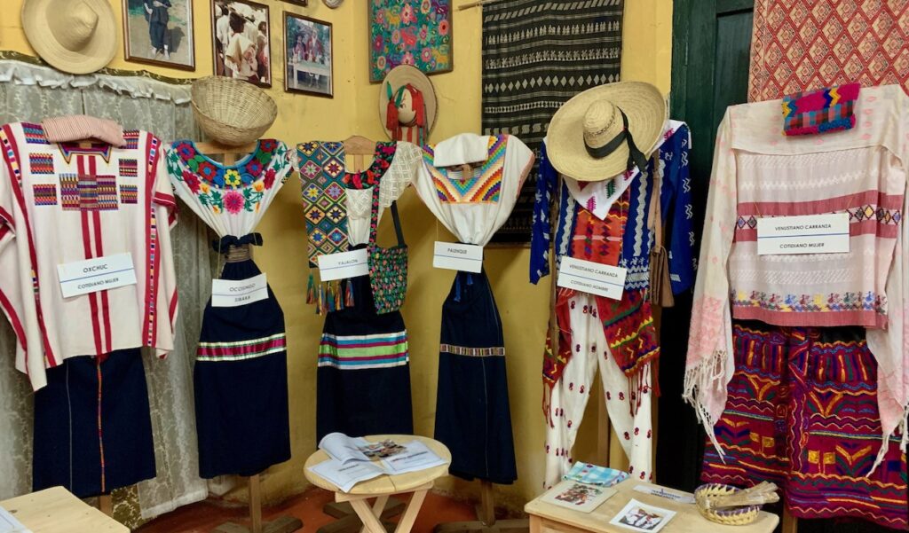
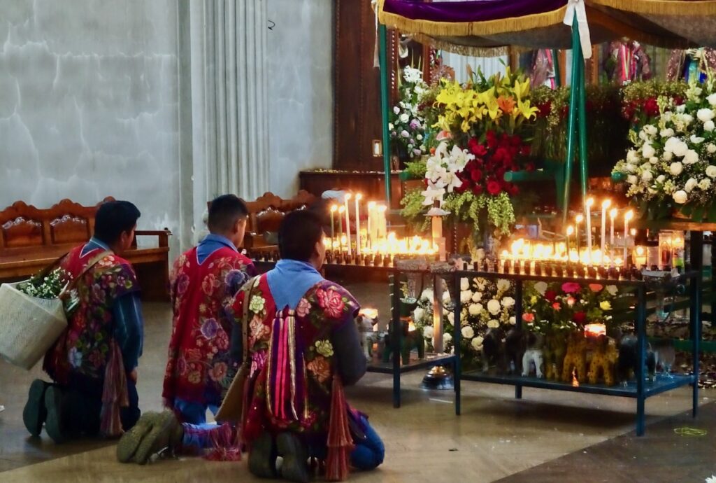
Textiles continue to be a rich Mayan tradition. Each village has a distinctive outfit, as shown in the Museum Sergio Castro in San Cristobal de las Casas. Sergio is a Mexican who moved to Chiapas and immersed himself in Mayan culture.The Mayan people today follow a religion that combines Catholicism with practices from their ancient traditions. In the town of Zincacantan, located about 10 km from San Cristobal de las Casas, villagers grow flowers, include floral designs into their clothing, and richly decorate their churches with flowers. In the nearby town of San Juan Chamula, visitors can enter a church where small groups sacrifice chickens and perform other rituals, but photos are not allowed.Jaquars remain an important part of Mayan culture and their images abound—these are all from San Cristobal de las Casas. Left-side jaguar. Replica of a jade death mask recovered from one of the ancient Mayan ruins. According to the Jade Museum where it is displayed, some families would spend their entire lives carving and polishing one mask for a ruler. All of this work was without the benefit of metal tools! Middle jaguar. An art piece in a museum. Right-side jaguar. Exterior wall art along a city street.
Thanks so much for another informative posting. We were fortunate, over a month in Mexico in 1990, to visit Chichén Itzá and Tulum and wander west to Merida (preceded by Guadalajara and Mexico City), one of four trips visiting various parts of Mexico. The Mayans who hosted us everywhere were the loveliest people I’ve ever met. I look forward to whatever OLLI classes of yours lie ahead!


Thanks so much for another informative posting. We were fortunate, over a month in Mexico in 1990, to visit Chichén Itzá and Tulum and wander west to Merida (preceded by Guadalajara and Mexico City), one of four trips visiting various parts of Mexico. The Mayans who hosted us everywhere were the loveliest people I’ve ever met. I look forward to whatever OLLI classes of yours lie ahead!
Awesome Gloria! Thanks for the comment. I’ll be doing an OLLI course about Patagonia in the fall. Happy summer!