

John Day Fossil Beds National Monument—paleontology
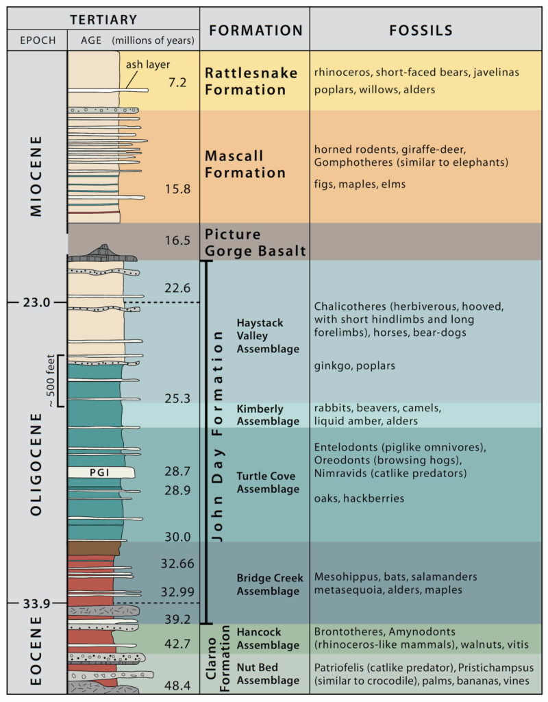
Paleontology is the study of plant and animal fossils to understand how life has evolved through geologic time. The John Day Fossil Beds are a world-class locality for such studies. According to Dr. Ralph W. Chaney, a paleontologist at the University of California Berkeley (UCB) who worked in the area from the 1920s through the 1960s: “No region in the world shows a more complete sequence of Tertiary (66–2.6 Ma) land populations, both plant and animal, than the John Day Basin.” He knew whereof he spoke, as he traveled widely to study plant fossils, which was his specialty. Note that Ma = millions of years ago.
The first paleontologist to study the John Day Fossil Beds was Thomas Condon, after whom the monument’s Visitor Center is named. He learned about the fossils during the Civil War, when an Army captain brought samples to him in The Dalles. The captain knew Condon—a minister and self-taught scientist—because he gave public lectures about geology in his church. Condon did not see a conflict between religion and modern science. He considered science a means to understand the spectacular nature of God’s creation and said: “The Church has nothing to fear from the uncovering of truth…Evolution was simply God’s method of working, and therefore not atheistic or infidel.”
Condon persistently studied the Fossil Beds. He published papers and sent some of his collection to prominent paleontologists on the East Coast, thus expanding knowledge of the region. The state of Oregon recognized his work by appointing him to a position as the first official State Geologist, and the University of Oregon hired him as a geology professor. Based on Condon’s studies, other scientists went to the region, including paleontologists from UC Berkeley, which today houses a large collection in their UCMP (University of California Museum of Paleontology).
How do fossils get preserved?
Scientists estimate that only 1/10th of 1% of all the species that ever lived became fossils. So fossilization is rare, and the likelihood that they are in a location where they can be discovered is even rarer. Here’s how it can happen (image from ScienceWorld).
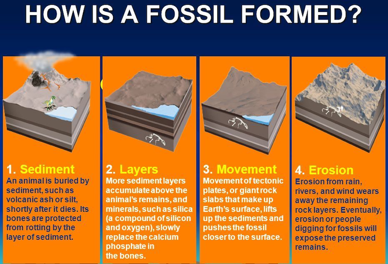
You now probably realize that volcanic eruptions are one key to the exceptional preservation in the John Day region (step 1 in diagram above). To be fossilized, organisms must be buried rapidly to prevent their decomposition. Although super-hot ash flows will incinerate most living things in its path, the ash at more distant locations can mix with water and sediments and cover organisms without incinerating them. Continuing eruptions can bury organisms’ remains beneath more layers, thus further removing them from the oxygenated atmosphere that is so destructive to organismal preservation. Rapid burial protects organisms from biologic factors such as scavengers and decomposers, and from non-biologic factors such as sun, wind and rain.
Another helpful factor in the John Day region is the sediments’ small grain size. Mud contains clay minerals that pack together and prevent oxygen from entering. Many of the organisms died in floodplains, marshes, or other low-energy environments where mud is the primary sediment type. Large-sized sediments often imply high-energy environments; where current action is strong, organisms’ remains can be broken apart and carried away.
Sometimes larger-sized sediments, which tend to have more pore space between the grains, can be conducive to fossil preservation. In volcanically-active regions, silica-rich fluids often flow through sedimentary layers and can replace materials vulnerable to disintegration with more resistant materials (see step 2 in diagram above). For example, bones can be replaced by minerals such as calcite, and wood can be replaced with quartz (called petrified wood).
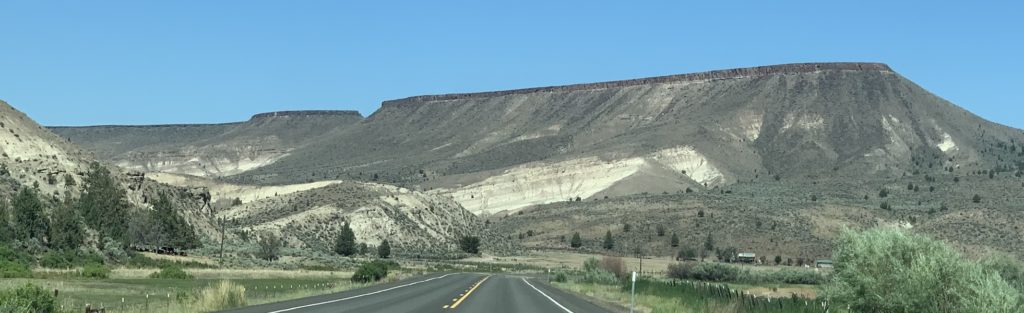
Fossils are more likely to be preserved in marine environments, because most of the seafloor is composed of mud that is below the action of waves. But the unusual conditions of the terrestrial environments in John Day—quiet-water environments where floods and volcanic eruptions quickly buried sediments—led to exceptional preservation. And then, luckily for us, during the past 7 million years the land has been uplifted and eroded, exposing the rich fossil record to our view (steps 3 and 4 in the diagram above). We will now look at some of the fossils that have been recovered, starting with the oldest unit.
Fossils in the Clarno Formation
The only place in the John Day National Monument where you can see in-place fossils is in the Clarno Palisades. This location consists of lahar deposits that flowed outward from a volcano into forests. There are many large clasts, but the matrix between them is mud that helped to preserve plant remains. The mud also caused the lahar to flow as a large thick mass, without the internal turbulence that would break up and destroy the plants.


These are photos of fossils we could see along the trails at the Clarno Palisades: impressions of many leaves (upper left), impression and bits of wood (upper right), single leaf (center right), and two whole trees (bottom). The trees were high on the cliff—they are about 30 cm (12 inches) in diameter. Apparently, the lahar flowed through the trees, knocking one over (horizontal tree), while the other managed to remain mostly standing (vertical tree). To see larger-sized images, click on each photo.


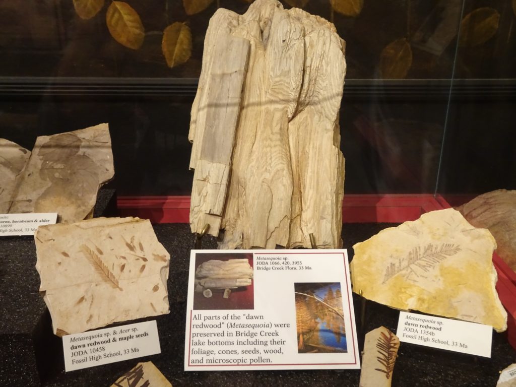
The so-called “Clarno Nut Beds” is another location, stratigraphically above the Palisades, where more than 170 species of plants have been identified, including more than 70 species of trees. The trees were petrified by silica-rich fluids, derived from volcanic activity, that seeped into the layers. The “nut beds” are not accessible to visitors, but fossils are displayed at the Visitor Center (photos above—to see larger images, click on each photo). You will notice that these plants are not ones you would find in the region today—for example, fossils include avocado, palm, magnolia and banana trees. Analyses of plant fossils indicate subtropical temperatures and rainfall up to 300 cm/yr (120 inches), about ten times the rainfall received in the region today (30 cm/yr or 12 inches).
The Hancock Mammal Quarry, another part of the Clarno Formation, stratigraphically overlies the nut beds and, as the name implies, it has yielded a large concentration of mammals. These organisms were preserved in a point bar of a meandering river. Point bars are areas next to river channels that are only covered with water during periods of high water flow. Animals would have gone to the point bar to drink from the river channel.
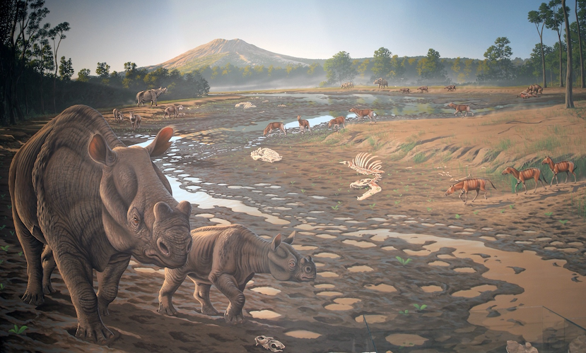
Fossil plants recovered from the Hancock Mammal Quarry indicate a coastal rain forest. At that time, most of western Oregon was under the ocean and the coastline was not far west of where the Clarno sediments were being deposited. Recovered animals are mostly vertebrate herbivores (plant eaters) that took advantage of the abundant vegetation. A few predators, such as alligators, have been found.
Fossils in the John Day Formation
Bridge Creek Flora. The oldest member of the John Day Formation—Big Basin Member—consists mostly of volcanic ash that formed clay soils (paleosols) weathered into a variety of earth tones (more about these soils in the next post). Between the paleosols are thin mudstone layers that were deposited in lakes and floodplains. These environments are conducive to fossil preservation because they are quiet, low-energy places where mud settles from suspension and organisms can be quickly buried. Preserved in these mudstones are leaves from more than 100 species of trees and, as in the Clarno Nut Beds, imprints of more than 50 species of seeds, cones, and nuts. Plants are also preserved in lignite—low-grade coal formed from peat beds in marshes.
Fossil plants indicate cooler temperatures and less precipitation than during Clarno time, but still warmer and wetter than current conditions in the region. Tree species such as maples, walnuts, alder, and birch are similar to those found today in deciduous hardwood forests in parts of Asia and the southeastern U.S.
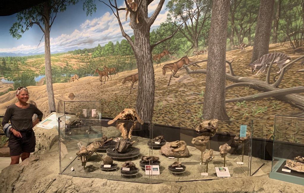
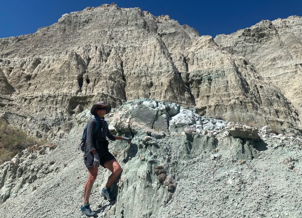
Turtle Cove Fossils. The Turtle Cove Member of the John Day Formation is the richest source of fossils in Oregon. These fossils make up the majority of the National Monument’s collection. When visitors are hiking in the Blue Basin area near the Visitor Center, they should keep in mind that the blue-green mudstones have yielded many fossils, although they only become visible after erosion events such as large rainfalls or landslides. The “Island in Time” trail gives visitors a sense of some of the recovered fossils. National Park Service scientists continue to look for new fossils and to study those that have been recovered.
About 100 different species of mammals have been identified in the Turtle Cove sediments, and more continue to be discovered. Plant fossils are rare in this part of the John Day Formation.


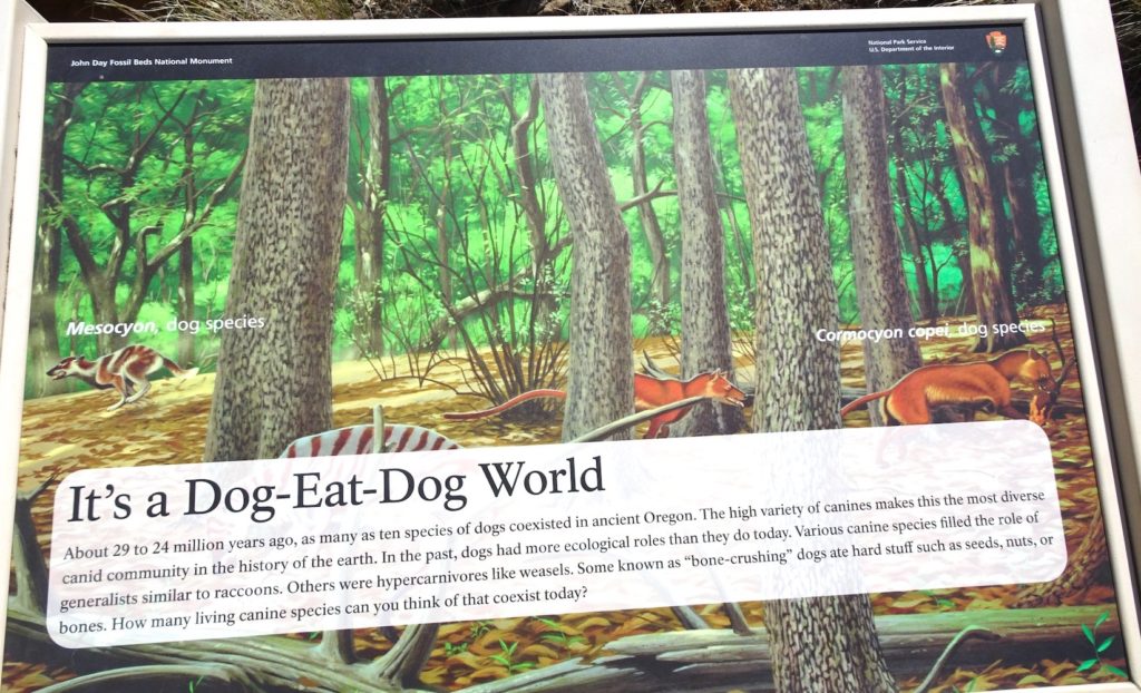
Photos above, except the upper right animal, were taken in the Visitor Center. Click on any image to enlarge it. One of the most common mammals recovered from the Turtle Cove Member was a group called oreodonts (skulls in lower-left photo), so named because of their sharp, pointed (mountain-like) teeth. They were a highly successful group that lived from ~40–5 Ma and may have been the most abundant organisms in North America during this time period. Oreodonts were herbivores that browsed on leafy plants in sheep-like herds, illustrated in center-right photo. They have been referred to as “ruminating (cud-chewing) hogs” because of similar characteristics to these animals, but they are most closely related (although distantly) to camels. These are organisms difficult to characterize! Other important browsers were three-hoed horses, mouse-deer, and beavers.
Some large-sized predators had evolved by this time. The largest was entelodonts, also called “hell pigs”, that stood up to 2 m (7 feet) tall (see illustration from the Encyclopedia Brittanica in the upper right). The skull (upper-left photo) shows the massive jaw and teeth that made it such a powerful predator. Also shown in the upper-left photo are a shell of a land-based tortoise and the bones of the cat-like nimravus, also referred to as “false-saber toothed cat”. Although they occupied an ecological role like modern cats, they are not related to them. The lower-right image shows a nimravus, a land tortoise, and a three-toed horse.
By this time, the climate had become cooler and drier. There were still forests, but they were more open, and grassy woodlands had developed, although grass was still uncommon. Organisms in the younger Kimberly and Haystack members indicate a continuing trend to more dry, open grassland environments.
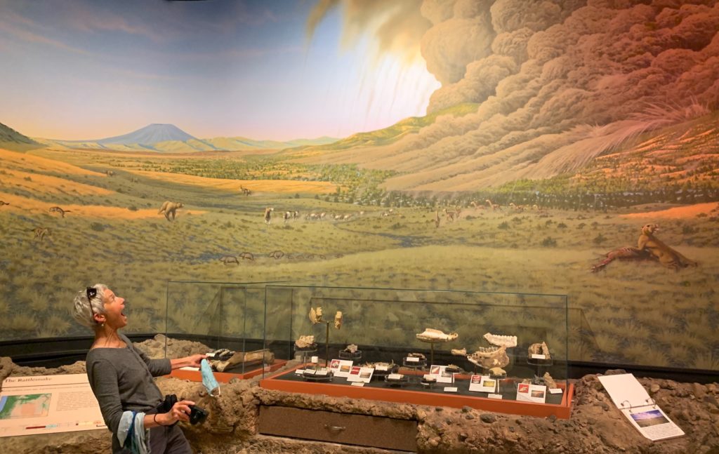
With the eruption of the Columbia River Basalts, called the Picture Gorge Basalts in the John Day region, plants and animals had to endure a million years (17–16 Ma) of eruptions, with lava continuing to cover the landscape, like it does in the southeast side of the Big Island of Hawaii. After the basalt eruptions ceased, woodlands were re-established, and the transition toward more grasslands continued. The landscape became more open, with long-legged hoofed animals such as horses and camels. By Rattlesnake Formation time (~7 Ma), the environment would have looked much as it does today, except for the presence of animals such as elephants and giant sloths.
In the next post, we’ll explore how the fossil changes through time seen in the John Day area relate to global climate change. I’ve also not yet explained how biostratigraphy works, and will briefly do so in the next post.