

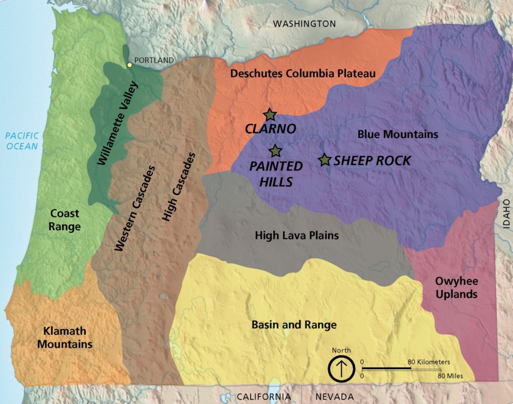
John Day Fossil Beds National Monument—stratigraphy
The John Day Fossil Beds is located in north-central Oregon. It was established as a national monument in 1974. The region has one of the world’s most complete records of fossils during the Age of Mammals, a period of time also known as the Cenozoic Era (past 66 million years). There will be three blog posts: (1) stratigraphy—how layers of sedimentary and volcanic rocks are distributed in time and space; (2) paleontology—how fossils record the evolution of organisms through geologic time; (3) climate—how organisms in central Oregon changed in response to climate changes during the Cenozoic Era.
A critical aspect of research in the John Day region has been to unravel the stratigraphic relationships among the sedimentary sequences where fossils have been recovered. This involves determining ages for the layers, and figuring out how the layers match up across distances (called correlating separate sequences of layers).
The stratigraphic column below summarizes the geologic units in the region and their relationship to the geologic time scale. A formation is a rock unit of a certain age that is distinctive, so that geologists can recognize it in the field when they are mapping the rock’s distribution.

In the column, the black layers with vertical stripes are volcanic layers that can be either lava flows or ash flows. The layers with dots and dashes are sediments—mostly fine-grained mud, silt and sand—that were deposited in terrestrial environments like streams and marshes. Many of these sediments contain abundant volcanic ash. The volcanic lava flows and pure ash layers are key to obtaining ages for the interstratified fossil-rich layers. The Eocene, Oligocene, and Miocene Epochs are subdivisions of the Cenozoic Era (past 66 million years). Image is from https://gotbooks.miracosta.edu/gonp/joda/html/jdstrat.htm.
Types of stratigraphic tools. The most obvious stratigraphic tool is lithostratigraphy—correlating sequences based on sediments that “look alike”. Biostratigraphy—correlating sequences based on their fossil content—will be discussed in more detail in the second post. Geologists have used these two methods since the modern field of geology was founded in the late 1700s. But they didn’t have numerical ages. For this, the field had to wait more than 150 years, until scientists understood how certain elements radioactively decay into other elements. It is only since the 1950s that geologists have been able to precisely date rocks and really understand the age of Earth’s materials. This is a field called chronostratigraphy—determining the age of geologic units.
So what has been used in the John Day region to provide the ages indicated on the stratigraphic column above? The essential ingredient is the numerous volcanic layers between the fossil-bearing sedimentary layers. Because sediments are mostly eroded pieces of pre-existing rocks, radiometric dating of sedimentary grains would yield ages for minerals in the source rocks, not the sedimentary rocks. In contrast, volcanic eruptions are instantaneous events that create new mineral crystals. Once a new crystal has formed and cooled, its initial ratios of isotopes are locked in and the radiometric clock starts. The isotopes of certain elements within the crystal then radioactively decay into other isotopes. Using sophisticated instruments, the ratio between the “parent” isotope and the “daughter” isotope can be measured, and a numerical age obtained.
Geologists use the volcanic layers between the sedimentary layers of the John Day Fossil Beds to obtain ages. They measure the radioactive decay of potassium to argon in potassium-rich minerals, such as sanidine (a type of feldspar) or biotite, commonly found in volcanic rocks. In the Turtle Cove member of the John Day Formation alone, seven volcanic layers have yielded precise dates that bracket the ages of the interbedded fossil-bearing sedimentary layers.


Some of the volcanic ash beds are pure enough (that is, not mixed with regular sediments) that they have been precisely dated (tephrostratigraphy). The Picture Gorge Ignimbrite (ash-flow tuff) is the thick purplish bed overlying the blue-green beds, just as it does on Sheep Rock. Layers like the PGI are called “marker beds” because they are distinctive (easily recognized by appearance and chemical composition), they are widespread, and they can be precisely dated by radiometric techniques. When you see the PGI, you know where you are in the stratigraphic sequence.


The Clarno contains ash-flow tuffs, sediments with grain sizes ranging from mud to boulders, and distinctive lahars, the deposits shown in the photo above. The large-sized clasts and strong consolidation of the clasts and matrix create a tough, resistant rock that forms a very different landscape than the soft hills created by the more erodable layers of the John Day Formation.
Lahars are debris flows with a mixture of hot ash, gas, mud and any debris in the flow’s path. They can rush rapidly down slope following an eruption or when water reactivates pre-existing volcanic material on the slope. The critical factor is typically ice and snow on a volcano’s peak that melt because of the eruptive heat and add the lubricant of water to create high-velocity dangerous flows.
Where are the volcanoes? The specific fossils in the Clarno and John Day formations will be described in the next post. In this post, I wish to address the question: where were the volcanoes that were erupting throughout the time the formations were being deposited? These volcanic layers are a critical element of this region, because they enable the precise dating of inter-layered fossil beds.
For a long time, geologists thought the volcanoes were an earlier version of the Cascade Range that was located farther east of the currently-active Cascade volcanoes (e.g., Mount Hood, Mount Saint Helens, Mount Rainier). Recently, however, geologists have discovered large calderas that are thought to be the source of highly explosive eruptions that spewed ash over vast distances, including the area of the John Day Fossil Beds National Monument.

Orange shading is approximate distribution of ash-flow tuffs in the John Day Formation. The Western, Southern, and Eastern Facies are exposures of the John Day Formation. A “facies” is a specific environment; for example, at the same time, sediments could be deposited in stream channels, floodplains, lakes, and marshes. These “facies” are spatially separate parts of the same formation.
Labeled areas with solid black outlines are physiographic provinces, as in the map at the top of this post. Labels with “FZ” are various fault zones. KBML is a gravity anomaly. Map is from McClaughry et al.’s (2009) field guide (https://www.oregongeology.org/pubs/og/OGv69n01-CrookedRivercaldera.pdf).

If you travel to Smith Rock State Park just north of Bend, you can see a thick sequence of tuff that was erupted from the Crooked River caldera. Smith Rock is at the northwestern edge of the Crooked River caldera and is pure tephra. In the John Day Formation, there are thin beds of pure tephra, but tephra is also mixed in with regular sediments deposited in streams, marshes, and other terrestrial environments.
The calderas in Oregon are among the largest known explosive eruptions on Earth! A caldera is a large depression formed when a volcano erupts and collapses. Crater Lake (misnamed) is an example of a small caldera. It measures 10X8 km in diameter and, when it blew up 7700 years ago, it erupted about 50 km3 of material. In contrast, the Crooked River caldera measures 41×27 km in diameter and erupted more than 580 km3 of material. Two of the calderas at Yellowstone National Park are even larger (see my post about Yellowstone: https://landscapes-revealed.net/the-geology-of-yellowstone-national-park-and-its-precursors-in-oregon-and-idaho/).
We now only see this type of giant caldera over the Yellowstone Hot Spot. The hot spot was probably a factor in Oregon, too, when the North American plate was located farther east and was overlying the hot spot. The Columbia River basalt layers are certainly related to the hot spot, as explained in my post about Yellowstone National Park (link in previous paragraph).
Another factor during John Day time was probably the down-going oceanic (Farallon) plate. From about 70–55 million years ago, the oceanic plate was descending from the west at a shallow angle, causing volcanism and deformation to move eastward to the Rocky Mountains. After that, the plate steepened, and volcanism migrated back westward to its current position—the Cascade Range. But that’s another, even larger, story!
Useful References
John Day Fossil Beds National Monument – National Park Service (NPS) Geologic Resources Inventory Report, by John P. Graham (2014): http://npshistory.com/publications/joda/nrr-2014-846.pdf
National Park Service web site about the John Day Fossil Beds National Monument: https://www.nps.gov/joda/planyourvisit/tcpc.htm