Warner Range in the northeast corner of California
August 11, 2023
Because of its remote location far from urban centers, the Warner Mountain Range is relatively unknown. We have thought about visiting this place, and exploring its volcanic rocks, for many years. We knew about the Warners because my husband Jay traveled through them on the way to his geologic field site in the Black Rock Desert in northwestern Nevada (see map below). He worked there in the 1980s as an employee of the U.S. Geological Survey. We finally got a chance to visit during a backpacking trip with three others on August 2–5. It was a relatively easy trip to make—just over three hours—now that we live in Ashland, Oregon. When living in San Francisco it would have taken us seven hours.
Geologic setting of the Warner Mountains
Here is a map of the Warner Range located in California (CA), near its intersection with Oregon (OR) and Nevada (NV). The eastern edge of the Warners is a normal fault called the Surprise Valley fault. It probably connects with the normal fault that creates the eastern escarpment of the Sierra Nevada farther south. This fault marks the western edge of the Basin and Range province that extends eastward to the Wasatch Range in Utah. The basins and ranges that make up this province are created by many normal faults that lift the ranges upward and drop the valleys between them downward (see profile below). This figure is from Ponce et al., 2009 (see reference at bottom of page).
This west–east (D–D’) profile across the Warner Range shows the Surprise Valley normal fault that creates the eastern escarpment of the range. The horizontal distance along the bottom of the profile extends from 0 km on the west (left) side to 58 km on the east (right) side. The vertical scale extends from a depth of -3 km to an elevation of +4 km. The maximum height of the Warner Range is Eagle Peak at 3,015 m (9892 ft). Offset on the normal fault is 8 km, as shown by the amount of separation between rock layers on the up-thrown side of the fault on the Warner Range and the down-thrown side of the fault beneath Surprise Valley.
The colors correspond to geologic units that are oldest on the bottom and youngest at the top. Green=late Eocene–Oligocene (~40–27.5 million years old) volcaniclastic sediments. Purple=Oligocene (~27–24 million years old) volcanic rocks that mostly consist of basalt and andesite—silica-poor to intermediate-silica-composition lava flows. Pink–red: Miocene (~19–15 million years old) volcanic rocks of many types, ranging in composition from silica-rich rhyolite to silica-poor basalt. Yellow: Young (<3 million years old) sediments that have filled the Surprise Valley since the Warner Range has been uplifted along the Surprise Valley fault during the past 3 million years. This figure is from Egger and Miller, 2011 (see reference at bottom of page).
These volcanic rocks are not part of the modern Cascade Range or the Yellowstone Hot Spot migration track. Rather, they are related to an earlier version of the Cascades, when the oceanic plate that was subducting beneath North America steepened and volcanism resumed in this area. Previously, a shallow-dipping oceanic plate had caused subduction-related volcanism to cease and move mountain building eastward to the present-day Rocky Mountains, an event called the Laramide Orogeny.
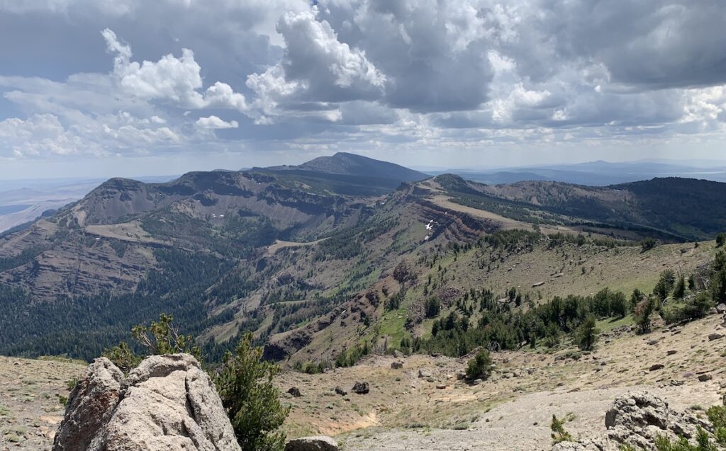
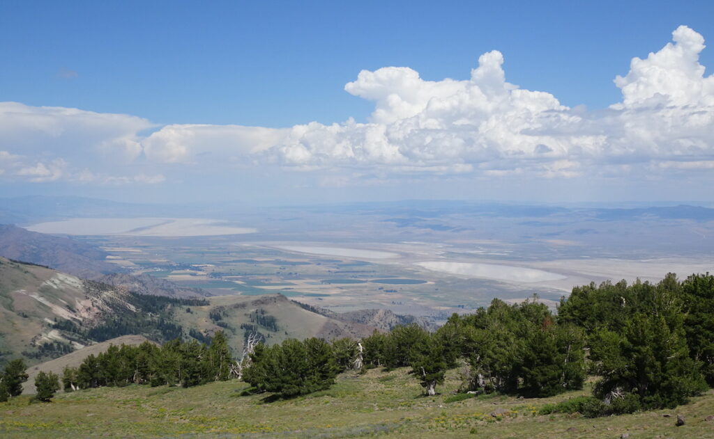
Like the profile above, this view is toward the north, with west on the left side of the photo and east on the right side. The volcanic rocks are tilted westward because of the Surprise Valley fault that has caused the range to be lifted upward (and tilted) relative to the rocks underlying the valley (upper-right part of the photo). The lake in the Surprise Valley is Alkali Lake. I took this photo from near our campsite at Patterson Lake, as we listened to a thunderstorm and watched it produce rain to the north of us.This view is in the opposite direction—toward the south—from the ridge above Patterson Lake. In this view, east is on the left side of the photo and west is on the right side. Again, we can see the westward-tilting volcanic rocks and the Surprise Valley to the east. The peak in the distance is Eagle Peak, the Warners’ highest elevation at 3,015 m (9892 ft).
Backpacking adventure
We traveled east from Ashland and stopped at Alturas for lunch—see map at top of page. From there, we made a quick stop at an obsidian mine (see section below) and then continued to the Pepperdine Trailhead where we camped overnight. The trailhead is located just north of the “M” in Mountains on the map above.
The next morning we set out on the Summit Trail that extends north–south along the crest of the Warner Mountains in the South Warner Wilderness area. Right away, I was stopping to take photos and examine the many types of volcanic rocks. Here I am in front of some basaltic lava flows.Here is a view heading south along the Summit Trail. Notice fellow hikers with backpacks. This is the typical landscape of the Warner Range. Some parts are moonscape-like, with bare volcanic rocks and little vegetation. Other parts have small trees that are bent toward the east by the prevailing westward winds. The views from the Summit Trail were incredible, as we could see the valleys on the west and east sides of the range, and also for long distances to the north and south.Here is a northeastward view of the Surprise Valley with its series of Alkali Lakes. The old-west town of Cedarville is located on the west side of the middle lake. We stopped there for lunch on our way back home to Ashland. Whereas the road to Pepperdine Trailhead is made of gravel, the route to Cedarville is an easier-to-travel, well-paved road. It’s the road shown crossing the Warner Range on the map above.The drab colors of the rocks were interrupted by the brilliant colors of wildflowers and butterflies. Left side: the aptly-named “rock-fringe flower”. Right side: Fritillary and swallowtail butterflies flit among the flowers of a coyote mint plant. The yellow-and-black patterned swallowtail is the official insect of Oregon. I guess we can call it the Oregon swallowtail, even though we saw it in California!Continuing south along the Summit Trail—Jay is in the bottom center for scale. On the left side of the photo is a columnar basalt layer. The upper cliffs bound the west side of Patterson Lake—our camping destination.A view of beautiful Patterson Lake where we camped. Although there was no water along the Summit Trail, we had abundant water to filter once we arrived at the lake. Since it was during the week, we saw only two other campers until Friday afternoon, when more campers arrived for the weekend.
According to our maps, a trail called the Upper Cottonwood Trail connects to the Owl Creek Trail that extends north–south along the east side of the Warner Range at a lower elevation than the Summit Trail. The trail no longer connects because of deferred maintenance, but it did get us down into delightful meadows and an area of hoodoos below our camp on the east side.
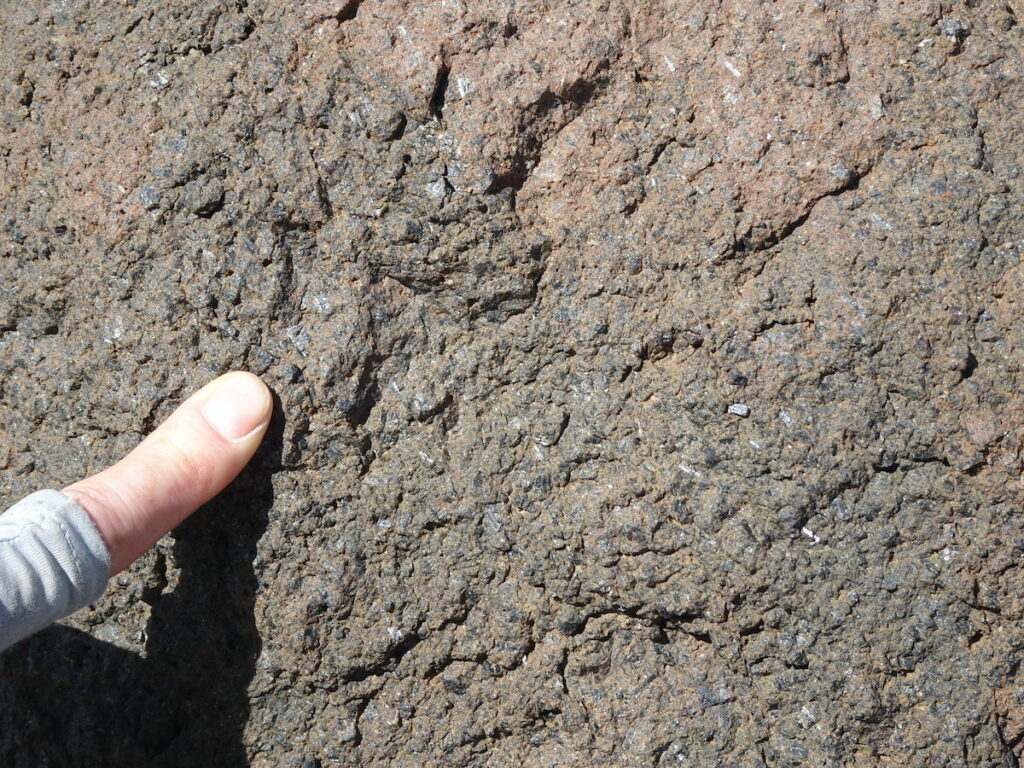
Jay and I enjoying the wildflower meadow on the eastern slope of the Warner Range below our campsite (right-side photo courtesy of Jay). There was abundant water on this side, and the flowers were in peak bloom since the winter’s deep snow had recently melted. Ongoing weathering and erosion have created these fantastical shapes called hoodoos. They are layers of volcanic tuff formed by ash flows from explosive volcanic eruptions. This is another example of the varying compositions of the volcanic rocks in these mountains—ranging from silica-poor lava flows to silica-rich explosive eruptions.Some of the other rocks we observed along the trail. Left-side photo: silica-rich rhyolite with phenocrysts—larger-sized crystals that form while magma is still underground. After the magma erupts, the remaining fluid cools quickly and forms only tiny crystals around the larger phenocrysts. Middle photo: volcanic rock where gas bubbles left cavities that were later filled by quartz crystals as silica-rich fluids moved through the rock. They are mini geodes! Right-side photo: Dark-colored, silica-poor igneous rock with visible crystals. The composition is similar to basalt but the large crystals suggest the magma cooled underground rather than being erupted.We enjoyed the lovely art work of nature along the trail. Left-side photo: The luminescent purple-colored penstemon plants were my favorite wild flower. Here they are next to an extensive field of corn lilies. Right-side photo: White-colored crystals in igneous rock cavities that, together with orange and green lichen, created exquisite patterns.Our backpacking group—Bart, Tony, Mary, Jay (and me the photographer)—at our campsite near Patterson Lake. Everyone looks cold because a thunderstorm pelted us with rain and hail during our last night. Hail was up to 1 cm in diameter! After 2 hours in our tents we managed to emerge for hot fluids and food. Yes, Jay did carry up one can of beer that he drank, even though it was not hot!
Obsidian mine
While in Alturas, on the way to the Pepperdine Trailhead, we stopped at the Modoc National Forest Service office to inquire about trails in the Warner Range. Although staff didn’t provide much information about the trails, they did inform us about local obsidian mine sites where collection was permitted. Since we had a few extra hours that day, we proceeded a short distance north to the Middle Fork Davis Creek site after obtaining a free collecting permit from the forest service office.
The map shows obsidian mining sites that are open to the general public. We choose the closest site at Middle Fork Davis Creek. Right-side photo: Tony standing on a slope covered with pieces of obsidian rock. Left-side photo: closeup of obsidian rock samples. Obsidian is silica-rich volcanic rock that is made of glass because the lava cools so quickly that crystals cannot form. We selected a few decorative pieces to take with us.
References
Ponce, et al., 2009, Geophysical Studies in the Vicinity of the Warner Mountains and Surprise Valley, Northeast California, Northwest Nevada, and Southern Oregon: U.S. Geological Survey Open-file Report 2009-1157. (https://pubs.er.usgs.gov/publication/ofr20091157)


Fascinating post. Geology, wildlife, and a nice hiking guide. You should publish a book from all your posts. Thanks for doing them!
Thanks Mark! But putting together a book would take away from time traveling and writing blogs! Maybe when I’m older…
Another great post! Photos are perfect as are the wildflowers and commentary – we always learn something new and totally enjoy it – thanks!
Thank you Isabel!