As seen in my last three posts, most geologic action occurs at the boundaries between lithospheric plates. But in some places we find active volcanoes and earthquakes that are not at plate boundaries. This post will explore these places, where geologic action is occurring at so-called “hot spots”. What are these features; what causes them; and what are some of their effects?
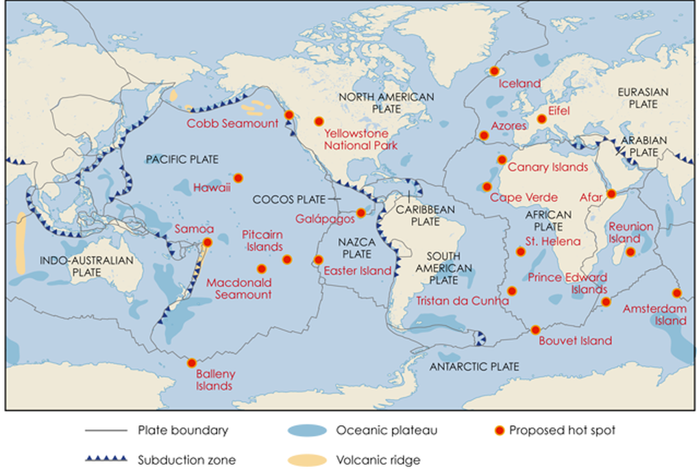
This map shows the major “hot-spot volcanoes” on our planet. Note that the majority are in the ocean, although some are also found on land. Some are closely associated with mid-ocean ridges (e.g., Iceland and Galapagos) and, indeed, hot-spot locations may influence the initiation and development of divergent plate boundaries. Hot-spots have been proposed based on locations where active volcanoes are found far from plate boundaries, or where mid-ocean ridges have extended all the way to the ocean surface because vast amounts of magma have bubbled up from Earth’s interior. Map from Earth magazine article.
To figure out what is causing so much magma to rise upward to Earth’s surface, we must look “beneath the hood”, that is, into Earth’s depths. This is no easy task, as it’s impossible to directly observe Earth’s interior; rather, our knowledge relies on interpreting remotely-sensed data, primarily from earthquake waves that pass through the planet. Consequently, there is still a lot of uncertainty about the details of how these “hot spots” actually function. During recent years, seismic tomography has enabled us to get more accurate “views” of Earth’s interior. Seismic tomography is analogous to a CAT (computed axial tomography) scan of the human body. Seismic tomography uses the energy generated from earthquakes (CAT scans use x-ray energy) and a receiver to record the data (seismic tomography uses seismograph stations; CAT scans use x-ray detectors and computers).
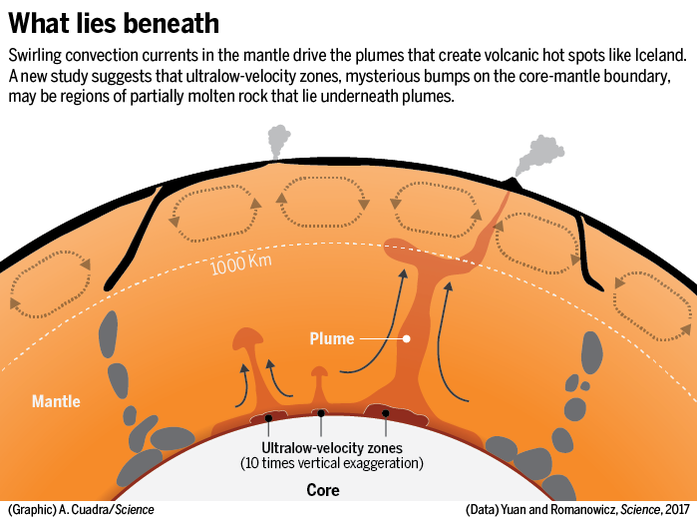
This profile view of Earth’s interior is based on seismic tomographic studies by UC Berkeley professor Barbara Romanowicz and her students. Although hot-spot locations look like “spots” on Earth’s surface, the features are better described as “plumes”. Since they appear to originate at the core–mantle boundary—~3000 km (1,800 miles) beneath Earth’s surface—and travel upward through the entirety of the mantle, they are referred to as “mantle plumes”. By convention, red areas are hotter than normal, for that depth, and blue areas are cooler than normal. Note blue areas beneath subduction zones, where cold lithosphere is falling into Earth’s interior, and red areas that are hot plumes feeding “hot-spot volcanoes” at the surface. They are identified where seismic velocities are low (and even “ultralow” at the roots of the plumes), since earthquake waves travel more slowly through hot solids than through cold solids. Mid-ocean ridges are shown on the up-rising limbs of the upper-mantle convection cells (loops with arrows between the surface and 1000 km depth).
To release heat from the liquid outer core, the solid rock in Earth’s mantle moves in slow, convective swirls, like a churning pot of hot syrup. It has long been hypothesized that circulation in the upper mantle is a primary driver of plate motion, but it is now thought that circulation operates within the whole mantle and some models show the convection cells extending down to the core-mantle boundary.
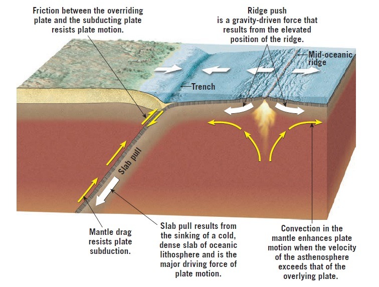
It is worth taking a moment to think about what drives plate motion. It was originally thought that upper mantle convection cells drive plate tectonics, as shown by closed loops in the profile view of Earth’s interior above. That idea has evolved as more data have been collected from Earth’s interior. Current dynamic models have plates moving as part of a gravity-driven convection system that pushes young hot plates away from spreading ridges and pulls old cold plates down into subduction zones. These drivers are shown in the diagram above, obtained from an engineering geology web site. Of course, these drivers are all fueled by Earth’s internal heat, which continues to be generated by the radioactive decay of elements such as uranium. Earth’s core temperature is estimated to be around 5,000–7,000° C (9,000–12,500° F)!
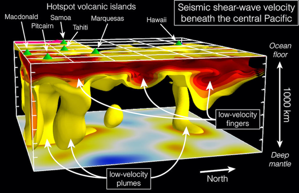
This 3-D image is based on seismic tomography studies at the Berkeley Seismological Laboratory (Phys.org web site). Hot areas, with low seismic velocities, are shown in red and yellow. The image illustrates the top 1,000 km of Earth’s mantle beneath the central Pacific, showing the relationship among the low-velocity plumes and fingers (also called channels). Green cones on the ocean floor mark islands that are “hot-spot” volcanoes above the plumes, such as Hawaii. The many island chains in the southern and SW Pacific have diverse origins—many are volcanic arcs associated with subduction zones (e.g., Mariana Islands), but others are “hot-spot” volcanoes associated with mantle plumes (e.g., Samoa and Tahiti). Note that the image above shows just the upper 1000 km of the mantle, but most of these plumes probably extend to a depth of 3000 km, to the base of the mantle.
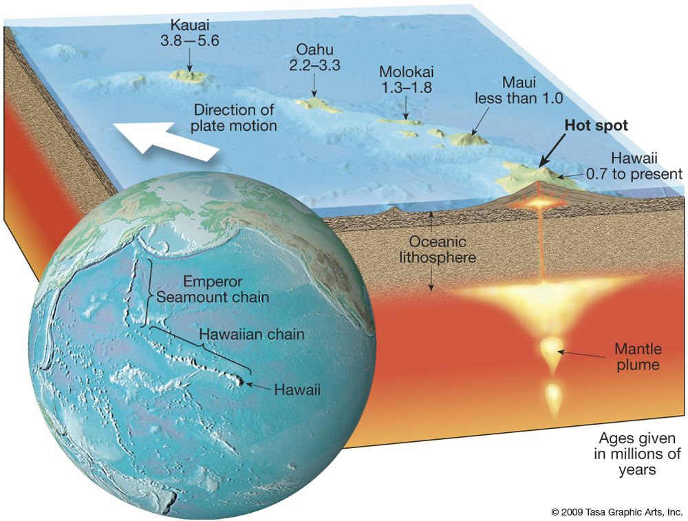
Let’s look more closely at the volcanoes of the Hawaiian islands, which are just the youngest end of a 80-million-year-old, 6,000-km-long mountain chain on the seafloor of the Pacific Ocean (Hawaii-Emperor Seamount chain). The Big Island of Hawaii is currently located over a mantle plume; the other islands are progressively older with increasing distance from the plume. For example, the age of Kauai’s basaltic lava informs us that it was over the mantle plume 3.8–5.6 million years ago. The orientation of the island chain informs us that the Pacific plate is moving to the northwest—imagine the mantle plume as a candle over which the Pacific plate is moving. We can use the volcanoes’ ages and their distance from the plume to calculate that the Pacific plate is moving NW at a rate of about 10 cm/yr (4 inch/yr). These islands are vast outpourings of lava—the Big Island of Hawaii has the greatest relief of any mountain on Earth, since lava has built up from the seafloor to the top of the island’s volcanoes, for a total relief of 10,211 m (33,500 ft).
On the globe view (above) we can see the rest of the volcanic chain that continues underwater in a northwest direction. As the Pacific plate moves northwestward, the volcanoes “turn off” as they lose their source of magma. They proceed to sink beneath the ocean’s surface because they cool and contract (much like oceanic crust as it moves away from a mid-ocean ridge), and because they are eroded by ocean waves. Once beneath the ocean surface they are referred to as “seamounts”. The northernmost seamount is 80 million years old, telling us that this part of the Pacific Ocean was located over the Hawaiian mantle plume a very long time ago—these northernmost seamounts are currently being subducted back into the mantle in the Aleutian trench. The bend in the seamount chain occurred about 47 million years ago. This tells us there was a change in the direction of Pacific plate motion from northerly to northwesterly. Interestingly, this is when India began colliding with southern Asia and some think this may have caused the plate reorganization. The mantle plume may have moved slightly to the south over the past 80 million years, but this motion has been much slower than the motion of the Pacific plate.
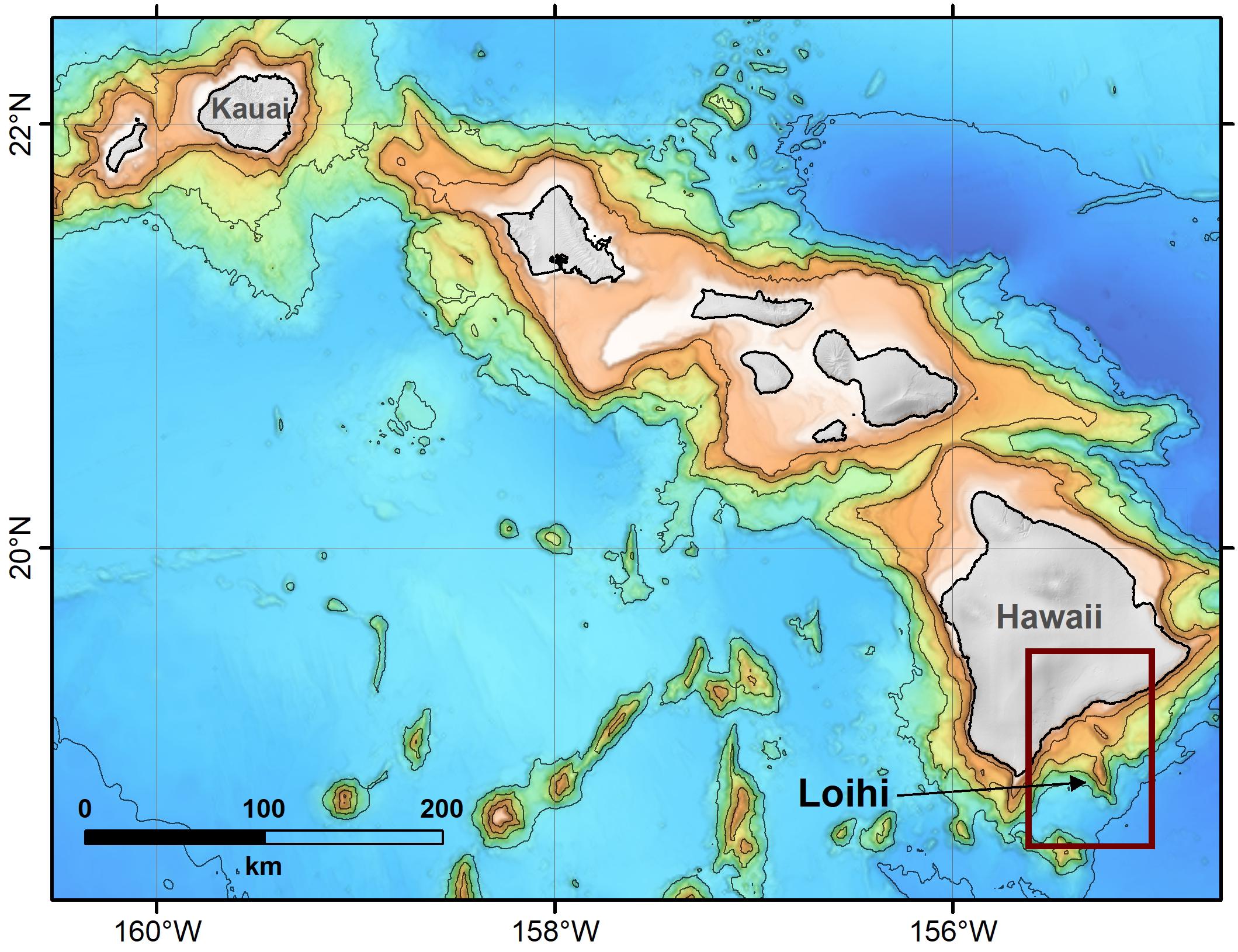
This map shows the bathymetry of the seafloor around the Hawaiian Islands. Contour lines are incremental one-km depths, extending from 1 km (orange colors) to 5 km (blue colors) below sea level. Loihi will be the next Hawaiian island—it is now about 1000 m (3300 ft) beneath sea level, but it will continue to built up to the surface, to become the new “Big Island” as the Pacific plate continues to move toward the northwest. Map is from research article about Loihi.
Another well-known location in the U.S. is the Yellowstone hot spot. Please link to my October 23, 2020 blog post about the Yellowstone hot spot, to see its path from southern Oregon to Yellowstone, as the North American plate has moved westward over a mantle plume (see second half of the post).
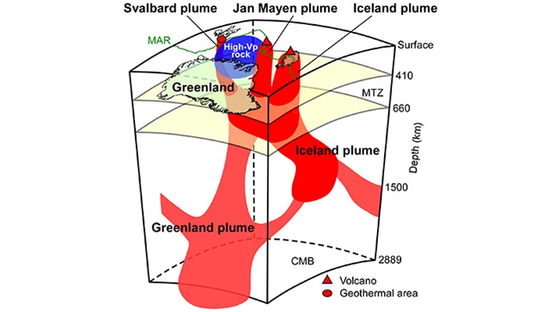
As discussed in my December 31, 2020 blog post about divergent plate boundaries, Iceland is an island located on the Mid-Atlantic Ridge. It has built up all of the way to the ocean’s surface because it is also fed by a mantle plume (see map at the top of this post). An extensive area of high heat flow in the North Atlantic motivated a recent study of this area that used seismic tomography to image Earth’s interior beneath Greenland and Iceland. The schematic diagram above is from a summary of the research. It shows multiple mantle plumes beneath Greenland and the surrounding regions—the research team discovered that the Greenland plume rises from the core-mantle boundary to the mantle transition zone beneath Greenland and feeds into the Iceland plume. Vp = P-wave velocity (red indicates slow wave velocity and blue indicates fast wave velocity); MAR = Mid-Atlantic Ridge; MTZ = mantle transition zone (410-660 km depths); CMB = core-mantle boundary at 2889 km depth. This research also has implications for climate change, since the mantle plume beneath central Greenland is contributing to ice melt in that region. The plume has two branches in the lower mantle that feed into shallower plumes that supply heat to volcanically-active regions in Iceland and Jan Mayen (a volcanic island north of Iceland) and the geothermal area in Svalbard.
We can observe some effects of mantle plumes on Earth’s climate today, and throughout geologic history. Indeed, mantle plumes have caused or contributed to the major life-extinction events.
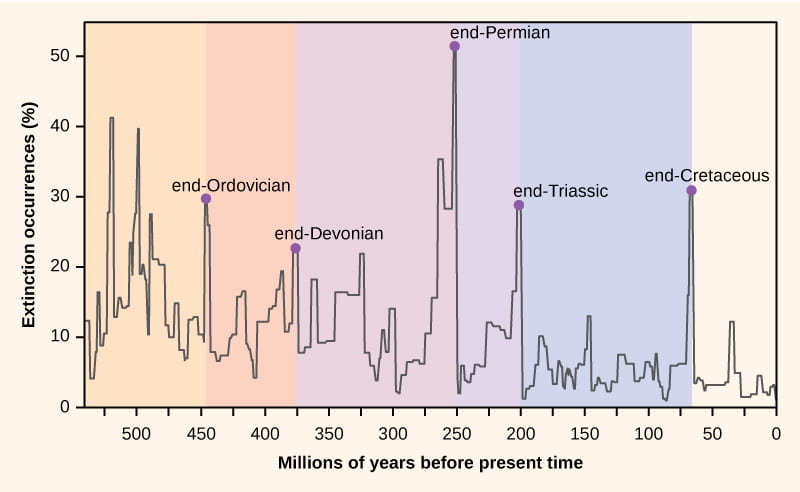
This chart (from Georgia Tech web site) shows the five largest extinction events during the past 550 million years, since multi-cellular life has evolved on Earth. The end-Permian extinction 250 million years ago was the largest extinction, with a loss of about 96% of marine species and 70% of all terrestrial species. The cause of this extinction was probably volcanic activity, generated over a massive mantle plume, that led to a runaway global-warming event. The eruptions, in what is now Siberia, led to a huge outpouring of lava for about one million years. Because the lava flows erupted through and ignited large coal layers, greenhouse gases, including methane and carbon dioxide, were emitted into the atmosphere and into the ocean, ultimately leading to toxic and anoxic (no oxygen) conditions that were lethal to life.
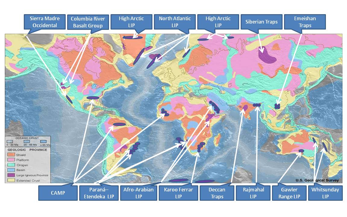
This map (from USGS web site) shows areas that are called “Large Igneous Provinces” (LIP). These are places where vast amounts of lava have been erupted, all probably because they were located over a mantle plume. Note the Siberian Traps, Earth’s largest LIP, called “traps” because the region is characterized by stair-step-like hills made by floods of basaltic lava (trappa is the Swedish word for stairs). The Siberian Traps are 250 million years old, coincident with the end-Permian extinction. The Columbia River Basalt Group in Oregon is also one of Earth’s LIPs—it formed about 15 million years ago, when the North American plate was located farther east, and Oregon was on top of the Yellowstone mantle plume.
Other LIPs have been implicated in the extinction events shown above. Even the end-Cretaceous extinction, famous for the demise of the dinosaurs, may have been at least partly the result of mantle-plume-induced massive volcanism. Most scientists agree that an asteroid hit Earth at the time of the extinction ~66 million years ago, but the second largest LIP (Deccan Traps in India; see map above) also was forming around this time. Ever more precise dating of the igneous rocks in the Deccan Traps suggests that global climate change already underway because of volcanic eruptions may have caused stresses that made life more vulnerable to extinction after the asteroid impact event. Some have even suggested that the asteroid impact caused an increase in eruptive activity. This article summarizes some recent studies.
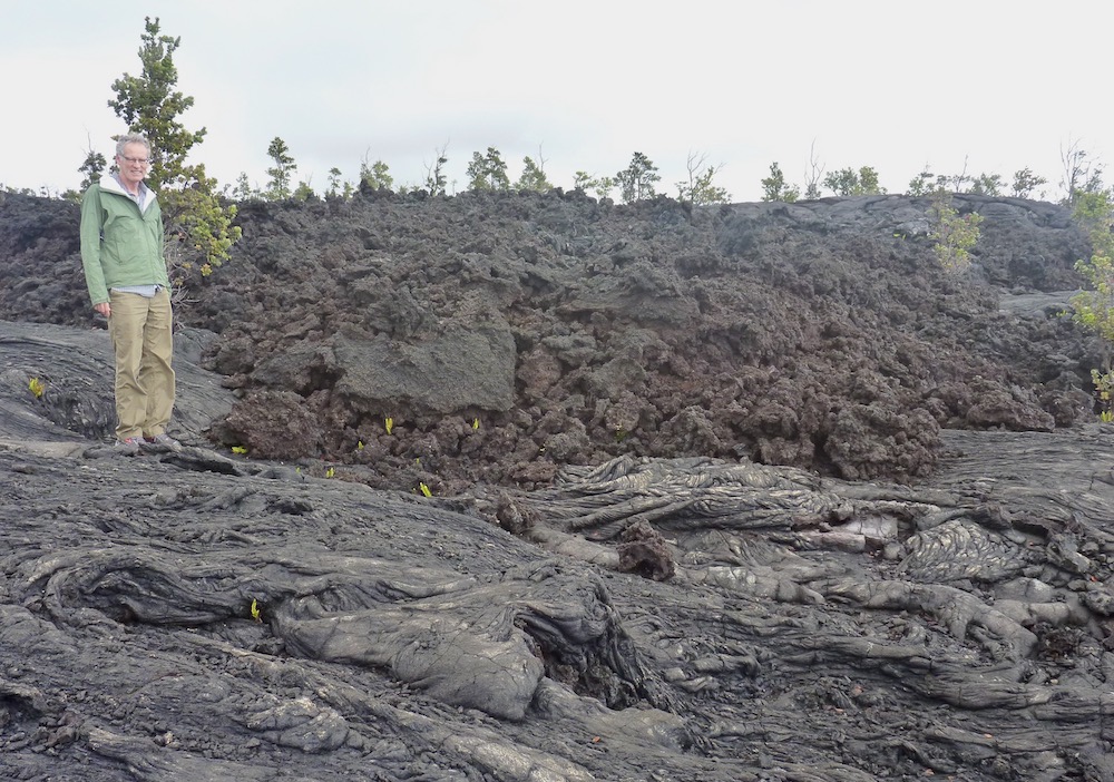
An example of basaltic lava flows generated by mantle plumes. This photo, taken on the Big Island of Hawaii, shows ropy pahoehoe flows overlain by blocky a’a flows.
In summary, mantle plumes are parts of our planet’s tectonic system that remain poorly understood and that are the focus of continuing research. One thing is certain—mantle plumes are an essential part of Earth’s heat transfer from the core to the surface. As such, they have had profound effects on Earth’s surface processes, leading to changes in the chemistry of land, atmosphere, and oceans that have extended so far as to cause massive extinctions of life. In today’s world, they are contributing to global warming in some places, but they are also creating gorgeous natural environments that we enjoy, such as the Hawaiian Islands, Yellowstone National Park, and Iceland.


Very fascinating and clear explanations of a complex topic!
Thank you!
A beautiful visualization of plate tectonics is an active lava lake:
https://www.usgs.gov/media/videos/eruption-and-lava-lake-halemaumau-jan-1-2021
You see floating continents, spreading center, mid-ocean ridges and sometime subduction.
Fabulous—and just 25 days ago in Hawaii! Thanks for posting this.