How did the Himalayas get to be Earth’s highest mountain range?
March 6, 2022
In my last four posts, I described the 21-day trek we did in the Everest region in November 2021, including some of our geologic observations along the way. In this final post, I explain how these mountains evolved to achieve such immense size and beauty.
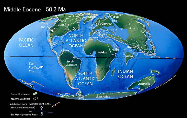
Here’s how Earth’s continents were distributed 50 million years ago (Ma). At about 200 Ma, the super-continent of Pangea started to break apart into our present-day continents. Important to our story, the continent of India moved northward from a position near Antarctica. By 50 Ma it was starting to collide with the Eurasian continent and to form the Himalayan mountain range. Figure from: http://www.scotese.com/newpage9.htm.
The inset map in the figure above shows the northward movement of India from 71 Ma (mya) to today. The three panels are 3-D schematics of tectonic plate configurations during this time period, while the continents of India and Eurasia (Asia) have been converging. In the top panel (60 Ma) the Indian plate consists of both continental (brown color) and oceanic (black color) crust. Because oceanic crust is more dense than continental crust, oceanic crust of the Indian plate easily sank beneath continental crust of Eurasia in a subduction zone along the southern coast of Asia. The blue color is a remnant of the Tethys Ocean that existed between India and Asia. As the oceanic plate got subducted northward, the ocean got smaller, until the dense oceanic crust was completely consumed beneath the Asian continent. The green color is oceanic sedimentary and igneous rocks that were scraped off of the down-going oceanic plate and attached to the overlying continental plate.
By the time of the middle panel (40 Ma), all of the oceanic crust had been subducted and the continental crust of India was colliding with the continental crust of Asia. Because both continents consist of less-dense minerals, neither one can easily descend beneath the other. Imagine two giant elephant seals crashing into each other, neither willing to give way to the other. The Indian plate is getting pushed beneath Asia along thrust faults, but it will not sink into the mantle like the oceanic crust did. This thrust-fault action has produced a double thickness of continental crust that helps to support the high mountain range as it grows. Sedimentary rocks formed in the shallow seas of the Tethys Ocean (purple color in top panel) were pushed down a little (purple color in the middle panel), an example of the thrust-fault action.
The huge thrust faults, shown by arrows in the bottom panel, are the result of immense horizontal forces produced as the continents continue to collide. As the Indian plate continues to move northward, these thrust faults push pieces of older, deeper crust to the south, over pieces of younger, shallower crust. To help visualize this process, see a sandbox experiment video: https://youtu.be/YtSkShrAQv0. Ignore the words and watch the video from 0:20–1:20 (one minute). Note how a horizontal push toward the right (north) causes the thrust faults to carry “crustal material” to the left (south). Also note how the “crust” thickens, how deeper material is pushed upward to the surface, and how the faults keep breaking out to the left (south).
Like shown in the video, as the horizontal forces continue, the Himalayan range grows higher and pushes southward toward India. The oldest faults are toward the north and the younger faults are farther south—they are initiated as the range impinges farther south into India. Note that, in the bottom panel (today), the purple-colored marine sedimentary rocks are exposed at the surface, including at the top of the mountains. These rocks are called the Tethyan Sedimentary Series (TS). Faulting has emplaced these rocks—limestone with fossils of marine organisms—at the top of Mt. Everest!
This is a cross section from south to north across the Himalayas from India to Tibet. Here is an explanation of abbreviations in the figure above and the figure below. On the north (right side), the ITSZ is the Indus-Tsangpo suture zone that separates the Eurasian continent from the Indian continent (also shown by green-colored rocks in the bottom panel above). The Tethyan Sedimentary Series (TS) are oceanic rocks that have been uplifted to high elevations, including to the summit of Mt. Everest. The South Tibetan detachment (STD) fault and the Main Central thrust zone (MCT) encompass the Greater Himalayan Series (GHS), the rocks making up the high Himalayas including the Everest region in Nepal. The Main Central thrust (MCT) and the Main Boundary thrust (MBT) encompass the Lesser Himalayan Series (LHS) of mostly unmetamorphosed rocks making up the southern foothills of the Himalayas, including the area around Kathmandu. The MBT, the Main Frontal thrust (MFT), and the Siwaliks fold/thrust belt (FTB) all connect at depth to the Main Himalayan Thrust (MHT). These faults are the primary actors, and creators of earthquakes, today.
This figure is another cross section, with more details of the High Himalayan region in the lower inset (see caption above for abbreviations). Most of the faults in this region are thrust faults that emplace deeper, older rocks from the north over shallower, younger rocks to the south (e.g., MCT at number 1). In the lower inset figure, notice how the metamorphic grade increases upward across the MCT (number 6). This is because rocks of the GHS that were metamorphosed at great depth have now been extruded upward over the younger, mostly unmetamorphosed rocks to the south. As the continental collision continues, the large horizontal compressive forces push the mountain range farther south and upward. Note the migmatites and leucogranites in the GHS (number 5) that I described along the High Passes Trek in previous posts. At the right edge of the cross section is a partial-melt zone now located deep below Earth’s surface (number 4). 20–30 million years ago the GHS rocks we now see at the surface were located at the depth of the partial-melt zone. Since then they have been pushed back up to the surface.
The STD is a normal fault with the opposite sense of motion than the thrust faults—refer to the arrows on either side of the STD in the cross section (number 2). Normal faults typically form in regions with extensional forces, where crust is being pulled apart rather than being pushed together. Although forces in the Himalayan region are compressive (pushing crust together), the STD has normal fault movement to accommodate extrusion of the GHS block, as explained in the next paragraph.
Consider again the inset figure, focusing on the GHS rocks between the STD and the MCT. Note the arrows labeled “extrusion” (number 8). This is a process called “channel flow”, whereby the GHS rocks have been squeezed upward between the MCT (thrust fault) and the STD (normal fault). Imagine the GHS as a blob of toothpaste that is being squeezed upward and southward by compressive forces between the two faults, acting as the top and bottom of the toothpaste tube. Because of greater temperatures at depth, rocks become ductile (that is, solid yet weak like toothpaste) and they can even melt partially to form migmatite or wholly to become leucogranite (number 5). As the rocks are “channeled” upward, the temperatures decline and the rocks become more brittle. Brittle rocks do not flow, but rather are moved by motion along discrete faults.
Here is a closeup of Mt. Everest (left) with companion peaks Nuptse (center) and Lhotse (right). I took this photo from Goyko Ri looking eastward. Notice that this view is the reverse of that shown in the cross sections above—north is on the left rather than on the right. Also notice the lighter-colored rock at the top of Mt. Everest. This rock is limestone formed in shallow tropical seas of the Tethys Ocean that contains fossils of marine organisms. It is unmetamorphosed sedimentary rock, in contrast to the high-grade metamorphic rocks that underlie it. This is because the STD (normal fault) has emplaced rock that was not buried deeply over deeply-buried rock, the opposite of thrust faults. The lighter-colored rock tilts northward along the northward-tilting STD—see cross section above that shows all faults tilting toward the north. The high-grade rocks below the fault are visible on Nuptse, where the leucogranite “balloon” (light color) of melted rock intruded into and pushed up the surrounding (dark color) metamorphic rock.
This photo is a stunning illustration of plate tectonics’ incredible power. Oceanic sediments with marine fossils got lifted up to the top of Earth’s highest mountain! Metamorphic and igneous rock that was buried many kilometers (many miles) below Earth’s surface was also uplifted to the top of the highest mountains. Both Everest and Lhotse are >8,000 m tall, and Nuptse is nearly that tall.
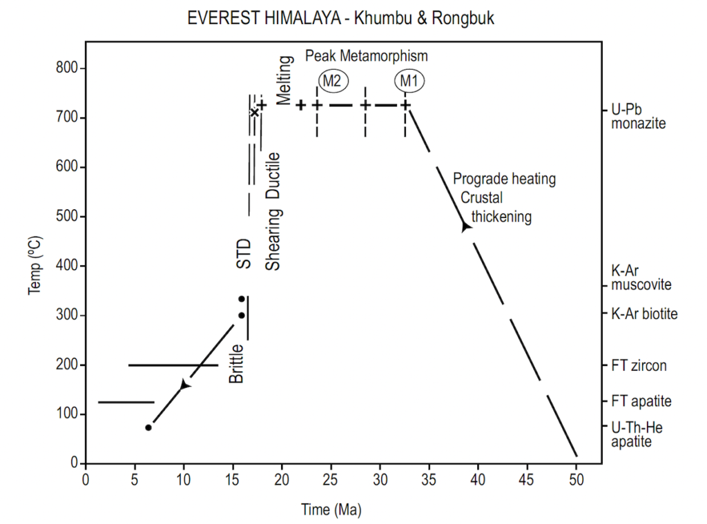
This graph summarizes the history of the Everest region during the past 50 million years—time in Ma is shown on the horizontal (x) axis. The vertical (y) axis shows temperatures ranging from 0–800° Celsius. On the right side of the graph are the isotopes (e.g., K-Ar) extracted from minerals (e.g., muscovite mica) that were used to determine past rock temperatures. The graph shows rocks of the GHS (Greater Himalayas Series) getting progressively buried to greater depths (i.e., higher temperatures) from 50–32 Ma (prograde heating and crustal thickening). Temperatures remained high from ~32–17 Ma, when the rocks were metamorphosed to high grade, and some even melted and then cooled to form leucogranites. Temperatures indicate a depth of around 15 km (9 miles). About 17 Ma, rocks of the GHS were rapidly lifted back up to the surface, first by ductile shearing (toothpaste behavior), then by brittle processes (like breaking a stick). This uplift was accomplished by extrusion of the GHS rocks between the MCT and the STD. Research suggests that these two fault zones are no longer active. Please refer to the yellow-colored cross section above. Most of the movement is now accomplished on the Main Himalayan Thrust (MHT) that connects upward and southward to the FTB and MBT. These faults are carrying the whole mountain range, piggyback style, southward over much younger sedimentary rocks.
The above graph is from Searle et al., 2003: https://jgs.lyellcollection.org/content/160/3/345. I would like to thank Mike Searle, the paper’s primary author, for sending me (from England) a paper copy of his Everest-region map.
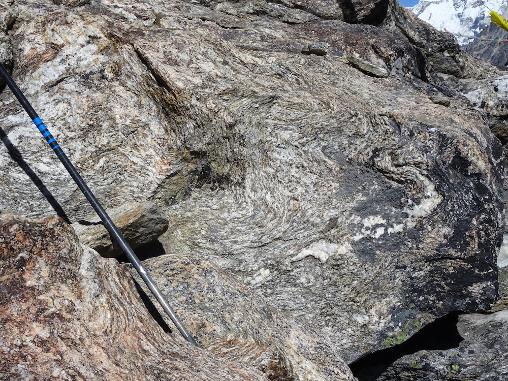
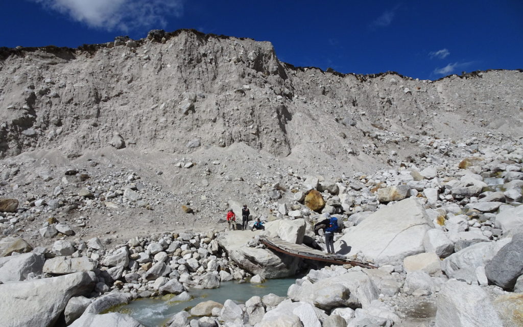
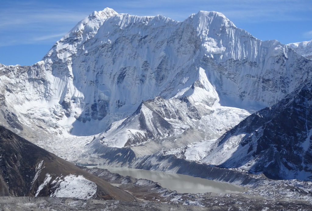
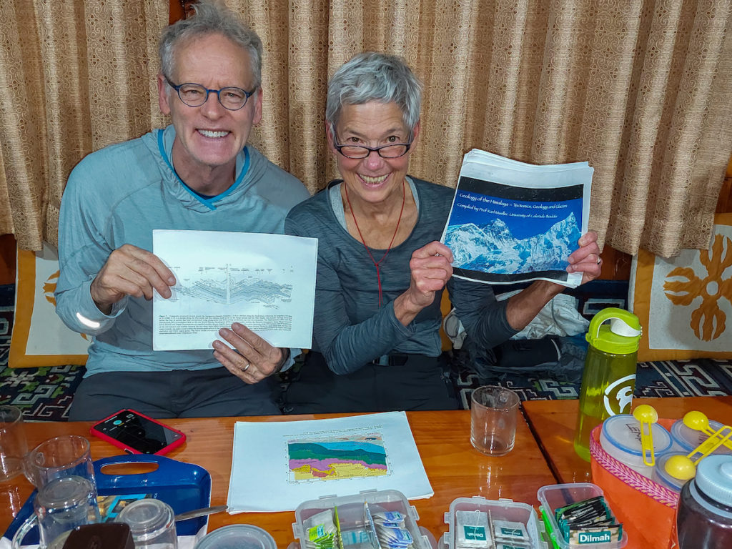
This photo shows a Great Himalayan Series (GHS) rock with large muscovite crystals (grey platey shapes) that is one of the minerals used to determine the temperatures (i.e., depths) reached by these rocks during metamorphism. This Great Himalayan Series (GHS) rock is gneiss—metamorphosed sedimentary rocks (hiking pole for scale). The convoluted layers indicate flow in a ductile state while buried at depth where temperatures and pressures were high. The thick white layer may have even melted. Later, the gneiss was channeled upward to the brittle zone where it was uplifted farther along the Main Central Thrust (MCT) and the South Tibetan Detachment (STD).Although the MCT and STD faults are probably no longer active, movement continues along deeper faults and the Himalayas are one of Earth’s major seismic zones. For example, the 2015 magnitude 7.8 earthquake began at a depth of 12–15 km (7–9 miles) and did not reach the surface. Evidence suggests the earthquake occurred because of movement on the Main Himalayan Thrust (MHT—see cross sections above). These fault movements continue to uplift the mountains at an estimated rate of around 1 cm/yr (0.4 in/yr). Evidence of continued uplift are the river terraces visible in all of the Khumbu valleys. The photo above, of the Bhote Koshi valley, shows flat terraced surfaces that were formed by the Bhote Koshi (river). During earthquakes the land was uplifted and new flat surfaces were created at river level. Other photos of river terraces were shown in previous posts.Another active process is glacial erosion. During the past 2.5 million years, since Earth has been in an Ice Age, glaciers have grown and enhanced erosion of the mountains. In this photo, three of our trek team are crossing a glacial river that has cut into a moraine after the glacier has melted away. Moraines are piles of sediments ground up by glaciers and then carried down-slope and deposited along the edge or at the terminus of the glacier. Because ice is so viscous, glaciers can carry sediments of all sizes—from the flour-sized silt that stays suspended in lakes and gives them a beautiful blue color to huge boulders such as those visible in this photo. As glaciers in the Himalayas shrink, sediments in moraines are becoming more visible. Because of global warming, glaciers in the Himalayas are melting at a rapid rate. This creates a variety of hazards, from destabilizing rocks on peaks that people like to climb, to producing catastrophic floods. This photo, taken on the slope of Chhukhung Ri (peak), shows a glacial lake that has formed because of melting ice. The lake is dammed by ice that can fail and release a large flood of water downstream. Yes, it’s true—Jay and I are geology nerds when we travel—especially when we travel to places as geologically interesting as the Nepali Himalayas. Here we are in the lodge at Namche, examining geologic reference materials provided to Kim Bannister by Karl Mueller, geology professor at the University of Colorado, when he trekked with Kamzang Journeys. Thanks Karl! Photo courtesy of Kim Bannister, Kamzang Journeys owner and guide (https://www.kamzangjourneys.com/).
In summary, because the India and Eurasian plates continue to converge at a rate of 40–50 mm/yr (1.6–2 in/yr), faults continue to move crustal pieces around, and the Himalayan mountains continue to grow and fill visitors to the region with awe.


Super powers, plate tectonics.
smile