Why are there so many hot springs in southeastern British Columbia?
May 25, 2022
When the Pacific NW chapter of the American Association for Women Geoscientists (AWG) announced a new field trip—”Southeast British Columbia (BC) Hot Springs Geology Tour”—I eagerly signed on! The 12-day trip promised we would “spend our days looking at geology and our evenings soaking in hot water! But I wondered—natural hot springs are most commonly found in areas of active or recently-active volcanism, where underground water gets heated by hot magma and then flows back to the surface. There have been no active volcanoes in BC for many millions of years, so why are there so many hot springs there? First, let’s take a look at our hot spring route.
The route of our BC hot springs geology tour. A friend from California and I drove to BC, crossing the border into Canada (yellow line) at Osoyoos (location 1). We continued north through Kelowna (location 2) to Revelstoke (location 3), where we met the rest of the group. On an extra day, we traveled north to Mica Dam (location 4—off the map, on the Columbia River north of Revelstoke), one of the largest earthen-filled dams in the world. The next day, May 1, twenty of us headed out in car pools to complete a counter-clockwise loop from Revelstoke. We went south and used a ferry to cross Arrow Lake and arrive at Halcyon Hot Spring resort (location 5), where we spent two nights. We continued south to Nakusp (location 6) where we visited two hot spring locations in the woods, then traveled east to Ainsworth Hot Spring resort (location 7), where we stayed two nights.
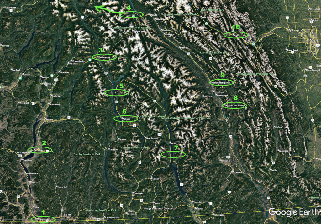
Our route swung north to Fairmont Hot Spring resort (location 8) and Radium Hot Springs (name of both the town and the hot springs at location 9), where we spent two nights. We continued northeast into the western edge of Alberta to soak in the Banff hot springs (location 10) and stay at the Fairmont Banff Springs, a venerable hotel that has been pampering guests since 1888. This range of mountains, with the well-known Banff and Jasper National Parks, is what most people think of when they refer to the Canadian Rockies. From Banff, we completed the loop, going back to Revelstoke and the mountains extending south from Revelstoke—the Kootenay Rockies—where we had spent most of our time. Finally, we returned to Kelowna, where I flew home on May 12.Most of the hot springs we visited are in developed resorts that include lodging and restaurants. At the Halcyon resort (location 5 on map above) we lodged in condos and consumed gourmet cuisine. The photo is a westward view over the hot pools and Upper Arrow Lake to the Monashee Mountains. Since it was early May, the mountains still retained considerable snow cover.
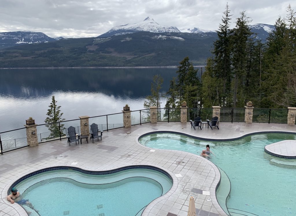
In contrast, St. Leon Creek hot spring is in a much more natural setting and required a 5.6 km (3.5 mile) hike up a steep trail. Nearby, we hiked on a shorter trail down to Halfway hot springs, a set of pools next to a beautiful river. Both of these hot springs are close to Nakusp (location 6 on map above). Photo courtesy of Sarah, who is sitting next to me in the St. Leon Creek pool.
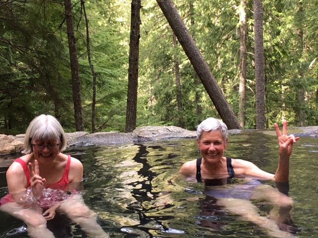
The Ainsworth hot springs (location 7 on map above) were first visited by the Ktunaxa First Nations people who, like many people since, enjoyed the hot mineral water for its healing and rejuvenating powers. Today the property has been returned to the native people—it is owned by Yaqan Nukly, the Lower Kootenay Band of Creston, BC. The present-day resort is built on travertine deposits that precipitated out of the mineral-laden waters over millinnea. In the left photo, notice the word “caves”. From this hot pool, visitors can walk through a cave to see where the hot water is being emitted from underground (right photo). These photos are from the resort’s web site: https://www.ainsworthhotsprings.com/.
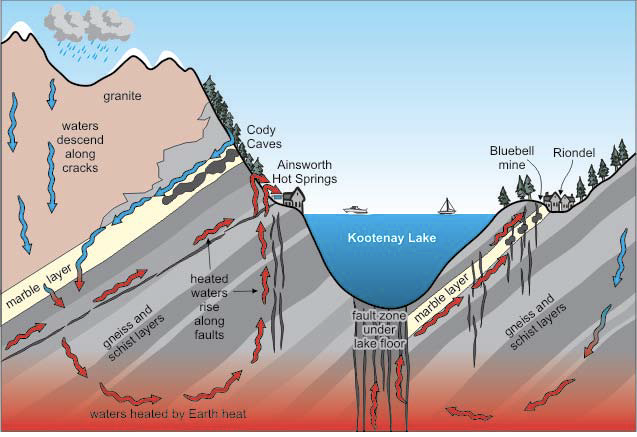
This profile from west (left side) to east (right side) illustrates how hot springs form in this region, which is riddled with fractures and faults (fractures with movement). Rain and snow melt percolate downward along fractures, are heated by Earth’s interior warmth (geothermal gradient), then flow back up to the surface along fractures. Marble (metamorphosed limestone) is made of calcium carbonate that easily dissolves in slightly acidic water. Areas of dissolution—this is what makes caves—are other paths for water to flow downward or rise upward.
The geothermal gradient is the rate of increasing temperature with depth in the Earth’s interior. The gradient is about 25°C per km of depth (1°F per 70 feet of depth) in most places, although it is higher in areas with active volcanoes. In BC, the “normal” geothermal gradient is sufficient to heat water, because faults extend deep enough below the surface to transport water to where the temperature is hot. This is why people can heat their homes using the geothermal gradient if they drill a well downward to access Earth’s interior heat. The figure above is from “Geotour guide for the West Kootenay” (see link at bottom of post).
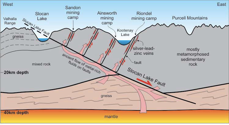
The process that causes hot springs is also responsible for creating concentrations of economically-valuable metals such as silver, gold, copper, lead and zinc. Water that has been heated during its transit downward can leach elements from the surrounding rocks. The fluids then rise back up to the surface and drop these elements into other rocks to create metal-rich ore deposits (red veins along faults in the profile). The region has many old mining towns, some with names like Zincton and Golden! In the late 1800s, the whole Kootenay region was bustling with mining activity. Some are still active, but many are closed. Not surprisingly, given the carelessness of past operations, many former mine sites have required environmental remediation. The figure above is from “Geotour guide for the West Kootenay” (see link at bottom of post).
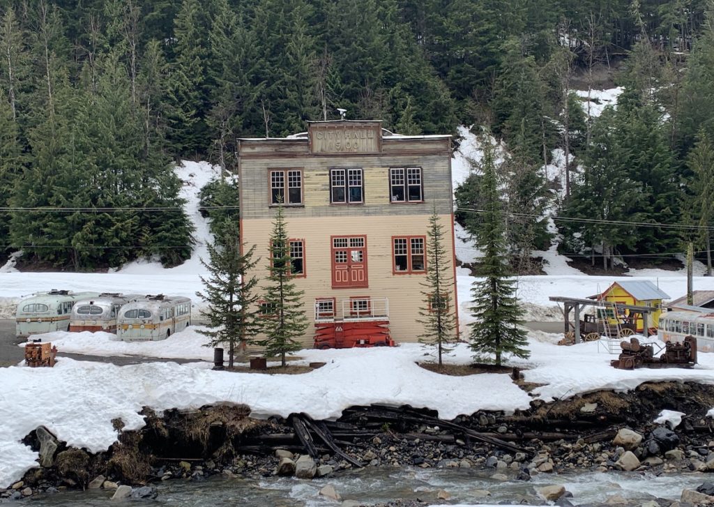
Sandon (west of Ainsworth—see location on profile above) is an example of an old mining town that, at its peak in the late 1890s, had a population of 5,000 and 24 hotels. It is sometimes referred to “western Canada’s most authentic ghost town”. We passed through Sandon but found little evidence of activity today. During summer months, people come here to visit a museum about the mining history. The photo shows the City Hall building that was completed in 1900. There were about 20 old buses sitting around, but we couldn’t figure out what they were doing there. Wood debris along the creek are remnants of former mining operations.
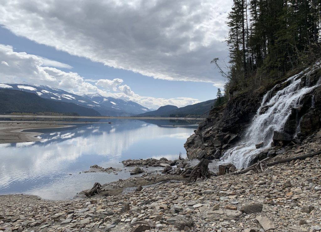
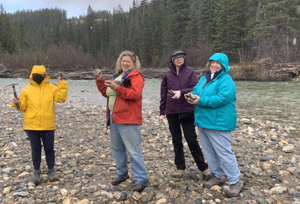
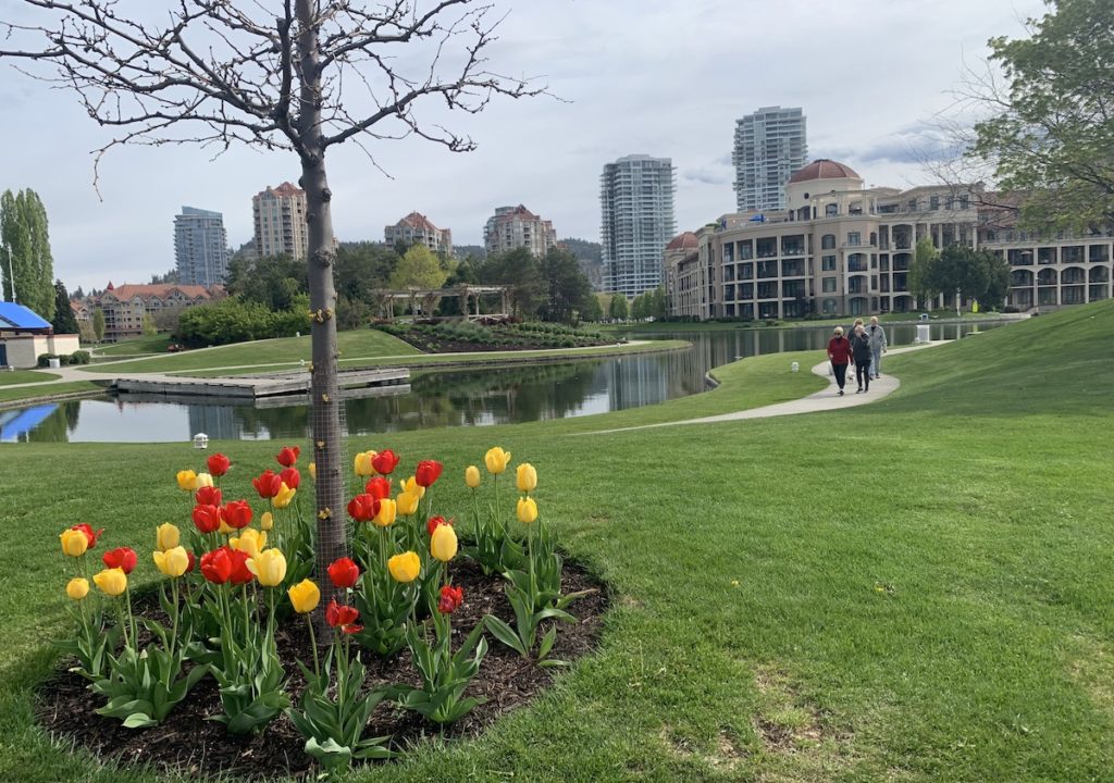
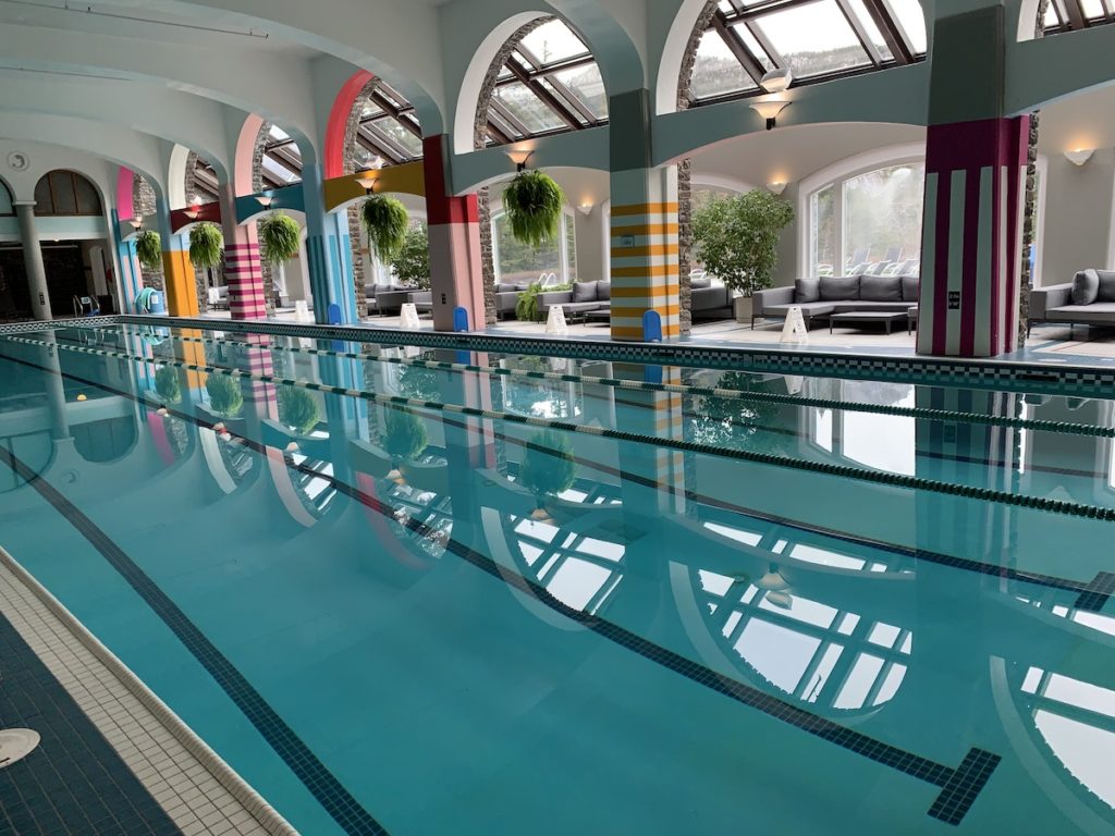
We also saw plenty of water that was not hot. The contrast in rock types and the severe erosion by glaciers have created many places for waterfalls large and small. Here is a gorgeous view looking south along Upper Arrow Lake (between locations 3 and 5 on map above). The “lake” is actually a reservoir on the Columbia River where a community was destroyed after the dam was build and the valley flooded. And yes, there were plenty of rocks! We often found ourselves looking for beautiful rocks along streams that carried examples of the rock types in surrounding mountains. Here are four of our intrepid group in their colorful raincoats, including our field trip leader Mindy in red.I’ll end with a trivia question—What is the fastest growing city in Canada? It’s Kelowna in BC (location 2 on map above)! I was there for a conference about 20 years ago, and the population has more than doubled since then. This photo on the edge of downtown shows high-rise buildings now scattered throughout the city. It’s popularity is no surprise—it’s located in the Okanagan Valley with more sun and warmth than most other parts of Canada. Downtown Kelowna is on the shore of Okanagan Lake with its numerous recreational opportunities. The Okanagan Valley is a paradise for fruit orchards and, more recently, wine grapes. Twenty years ago, the wines were not that great; however, based on the wines I sampled, they have improved greatly since then. Kelowna is close to the Canadian Rockies to the east and the BC coast with jewels such as Vancouver Island to the west. OK, one more trivia question related to the topic of water. What is the world’s best pool to swim in? This is an opinion, of course, but of all the pools I have swum in, the pool in the Fairmont Banff Springs Hotel is the best.
So put this region on your bucket list! Subsequent posts will focus on the source of the Columbia River and the basic geologic history of the region.


Hot diggity, girl — you know how to field trip! I want to swim in the Fairmont pool. Looks amazing. Of course so do the hot springs!!
We’ll darn, I was at the Banff Springs Fairmont 15 years ago and never checked out the pool!
You probably at least sampled the Banff Hot Springs!