My first post about the Italian Dolomites described how the carbonate platforms formed from the hard parts of organisms living in shallow parts of a warm, tropical ocean (https://landscapes-revealed.net/trekking-through-an-ancient-sea-in-the-italian-dolomites/). The second post described other rock types in the Dolomites, namely igneous rocks and sedimentary rocks transported to the ocean from land (https://landscapes-revealed.net/not-all-of-the-rocks-in-the-italian-dolomites-are-dolomite/). Although created near sea level, the highest peaks of the Dolomites now reach elevations of nearly 3350 m (11,000 ft). How did these carbonate platforms that were “born” at sea level reach their current elevations? Like most other high mountains, the answer is compression—tectonic plates converging (i.e., moving toward each other) and pushing parts of Earth’s crust upward along faults.
Faults and folds formed by compression
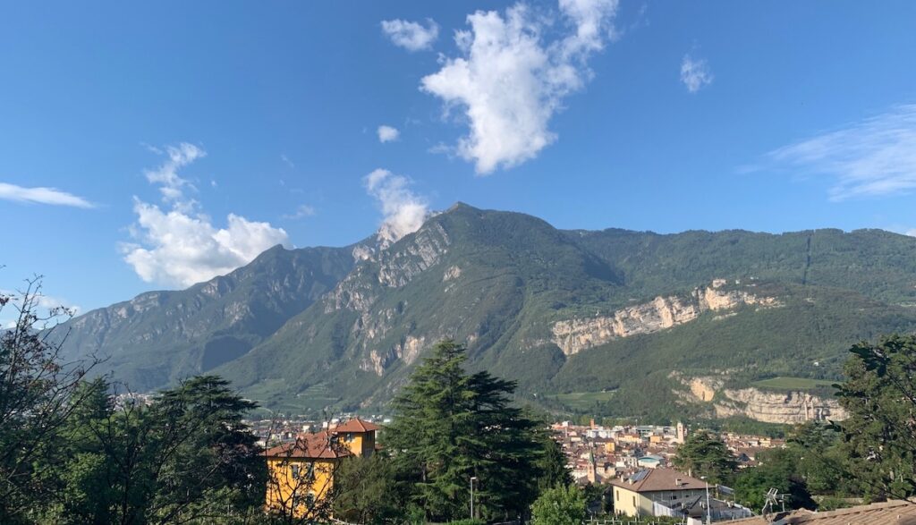
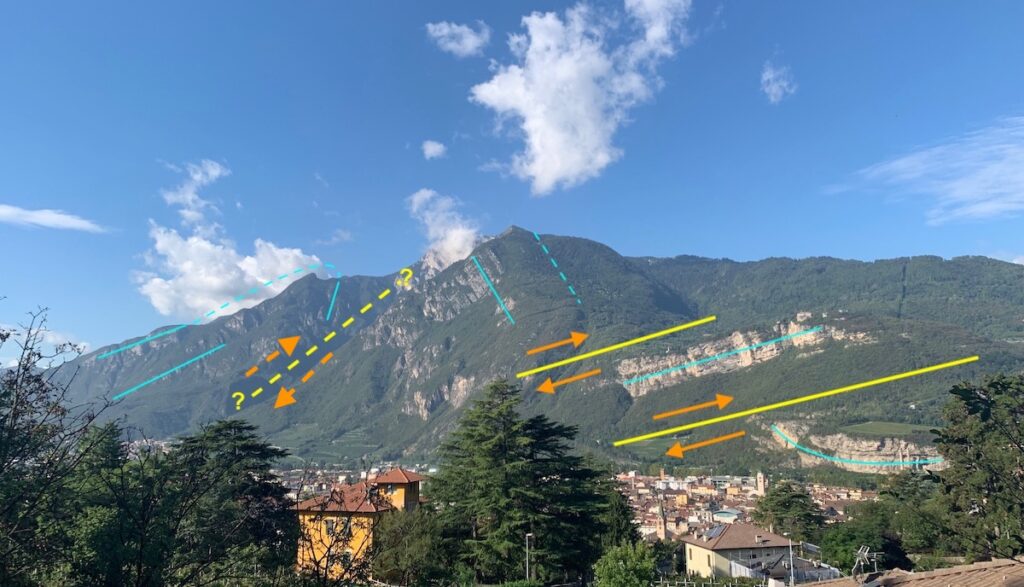
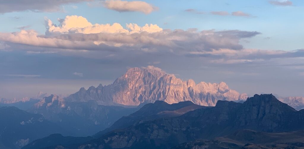
This view is westward over the town of Trento to the Brenta Dolomites. Trento is located in the Adige Valley, which separates the main part of the Dolomites from the smaller Brenta Dolomites. In the next image I’ve labeled the sedimentary layers of dolomite and the faults that deformed these layers.Light blue lines are orientations of the sedimentary layers—solid where clearly visible and dashed where inferred. The blue lines indicate that the originally horizontal layers have since been tilted, folded, and offset. The responsible structures are thrust faults, indicated by yellow lines—solid where clearly visible and dashed where inferred. Orange arrows show the direction of motion along the thrust faults. It is only in a compressive tectonic setting that solid rocks can move upward, against gravity, over other rocks. In this way, it is possible to juxtapose older rocks on top of younger rocks—opposite to how they were formed. Usually, the rocks are first folded until they are strained so much that they break along faults. Thick carbonate-platform rocks are difficult to fold, as explained below.
When did this compression and uplift occur? In the first post (link above) I included a map showing how the continents were arranged in the Triassic Period when the Dolomites were formed. At that time, the Tethys Ocean separated Eurasia from Africa. Over time, the ocean shrunk because the Eurasian and Africa plates were converging, in the process compressing pre-existing rocks and creating the Alpine range that extends from France, in the west, to Austria, in the east. This mountain-building episode is called the Alpine Orogeny, and the Dolomites in Italy are the southeastern part of the vast Alpine range. If you look at my posts in September 2019, you will see three blogs describing the western part of the Alps in Switzerland. The Alps have formed in successive episodes during the Cenozoic Era (past 66 million years), and the Dolomites may still be slowly rising.
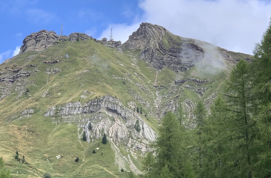
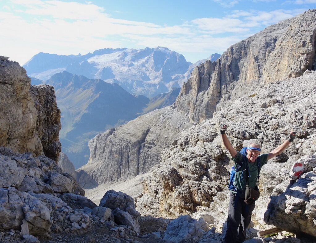
What is evident in the Dolomites is the different behavior of rocks under the same compressive stress. This photo shows how you would expect layers to behave when pushed on from both sides—think of a carpet that crumples when pushed. The layers are thin interbedded limestone and mudstone that can move relative to each other and fold easily. The rocks are part of the Pale di San Martino range. These thin-bedded rocks underlie the thick-bedded rocks of dolomite.Unlike the thin beds of sedimentary rock shown above, the dolomitic carbonate platforms are massive rocks that behave as a single layer and, because they are so thick, they do not crumple into folds like the layers in the previous photo. Instead, they get lifted up as a single large mass, as shown in this photo. Jay is standing on a saddle at the edge of Piz Boe peak (elevation: 3150 m / 10,340 ft), with Marmolada peak in the distance (elevation: 3344 m / 10,968 ft). Notice that the carbonate layers in Piz Boe are horizontal, showing that they got uplifted “en masse” without much internal deformation.Here is another beautiful mass of uplifted carbonate rock—a view from Refugio Kostner at sunset.
Elevation brings glaciers
Because of compression between the African and Eurasian plates, the Alps were uplifted to elevations high enough to receive abundant snow. If snow accumulates faster than it melts, it forms glaciers. During the last glacial maximum about 20,000 years ago, the Alps were covered with glaciers that have decreased in area since then. With anthropomorphic climate change now impacting our planet, the glaciers are shrinking even more rapidly. The so-called “queen of the Dolomites” glacier on Marmolada, the Dolomite’s highest mountain, could be completely gone in just a few years. The Dolomites are a popular place for skiing, hiking, and mountaineering. As explained in the caption to the next photo, these activities are becoming increasing dangerous.
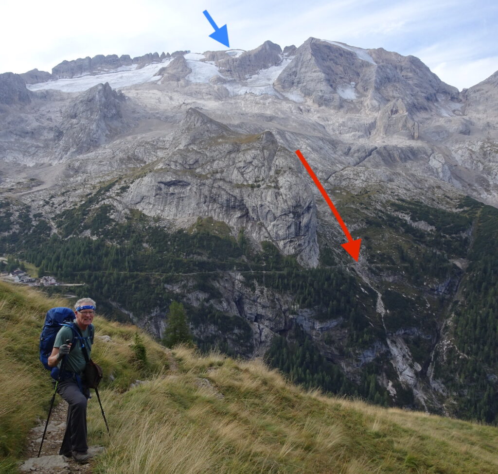
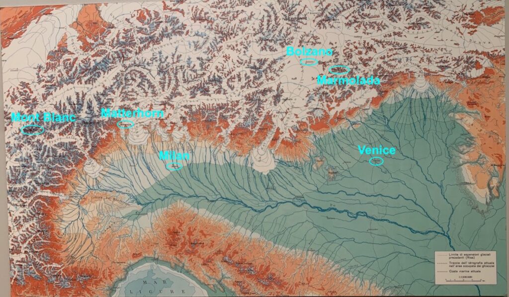
This view is the north slope of Marmolada, the Dolomites highest peak (elevation of 3,343 m / 10,968 ft). White areas are the remnant glaciers, one of which broke apart earlier this year. The blue arrow points to where a large ice piece broke off of the glacier in June 2022; the red arrow shows its path down the mountain. Unfortunately, a mountaineering team was climbing the mountain and got hit by the avalanche of ice. Tragically, eleven hikers were killed and eight more were seriously injured. As global warming continues, these types of events will become more common. This article in Wired magazine provides more details about the event and efforts to monitor the glaciers to prevent future tragedies: https://www.wired.com/story/marmolada-glacier-collapse/.I took a photo of this map in a museum in Vigo di Fassa. It shows how northern Italy would have looked during the last glacial maximum ~20,000 years ago. I’ve annotated one location in the Dolomites—Marmolada mountain; one location in the Adige Valley—Bolzano city; two locations in the western Alps—Mont Blanc in France and the Matterhorn in Switzerland; and two Italian cities south of the Alps—Milan and Venice. The river system is the Po River that extended much farther east and south. Because so much water was held on land as ice, sea level was about 130 m (430 ft) lower than it is today. Consequently, Venice was then a long distance from the ocean and the Adriatic Sea is not even visible on this map. On the northwest coast of Italy, the slope into the sea is very steep, and the Ligurian Sea (Mar Ligure) is visible there. Notice how much ice covered the Alps and how individual glaciers extended south into the Po Valley. Famous lakes such as Lake Como and Lake Garda are the results of glacial scouring before the glaciers retreated northward.
Food and wine
I can’t leave the Dolomites without a photo of food and wine, which were delicious, of course! Both of these photos are from restaurants in Bolzano at the northern end of the Adige Valley, a part called “Alto Adige”. The neopolitan-style pizza was named “tricolore” after the three colors of the Italian flag. It included fresh and dried tomatoes (red), arugula (green) and burrata with an olive oil injector (white). The wine is Pinot Nero (Pinot Noir), a varietal done very well in the Alto Adige region—almost as good as in our home state of Oregon!


Wonderful! The Italian Dolomites are spectacular! PaHope to go back sometime. Thanks for the culinary recommendations, too.
Wonderful Pat – thanks!