Trekking through an ancient sea in the Italian Dolomites
October 7, 2022
The main purpose of our August–September trip to Italy was to explore the much-lauded Dolomite Mountains, located in northeastern Italy (Trentino-Alto Adige province) just a few hours north of Venice.
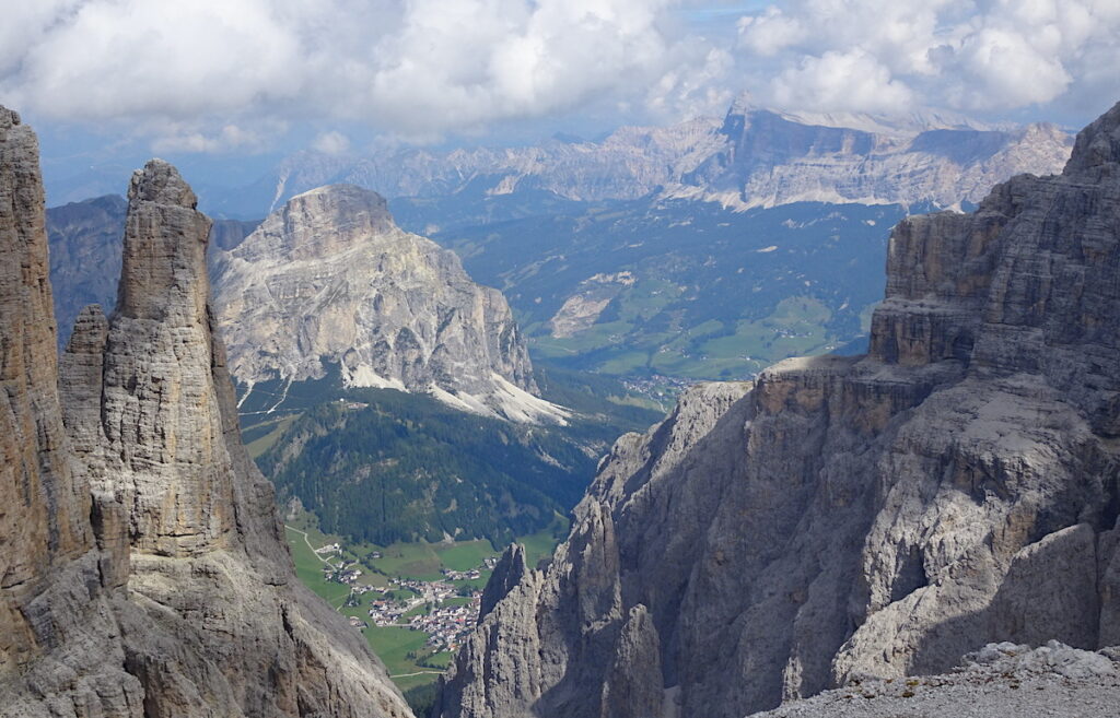
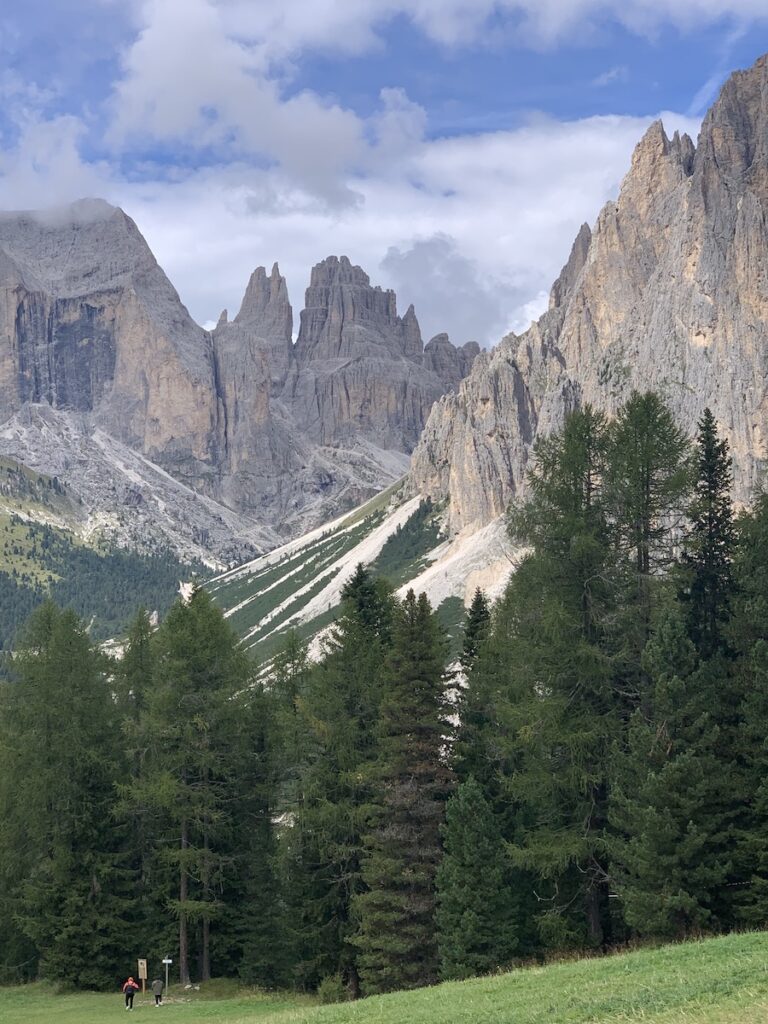
The gleaming steep-sloped white mountain blocks separated by verdant valleys were just as spectacular as we had been led to believe! This view is northeastward from Piz Boe (see 3-D image below). We hiked in the western Dolomites and this view is toward the eastern Dolomites. Note landslide (light patch) on the slope between the sun-lit isolated peak and the distant ridge.
We used a local company (Mont Trekking: https://monttrekking.com/) to get trail information and to make reservations in refugios where we stayed at the end of each trekking day. From their web site we choose the “Fassa Dolomites” 8-day trek described below. We spent another 9 days doing shorter hikes around the periphery of the mountains, mainly from the towns of Bolzano and Trento in the Adige Valley that is located just to the west of the area shown in the image below.
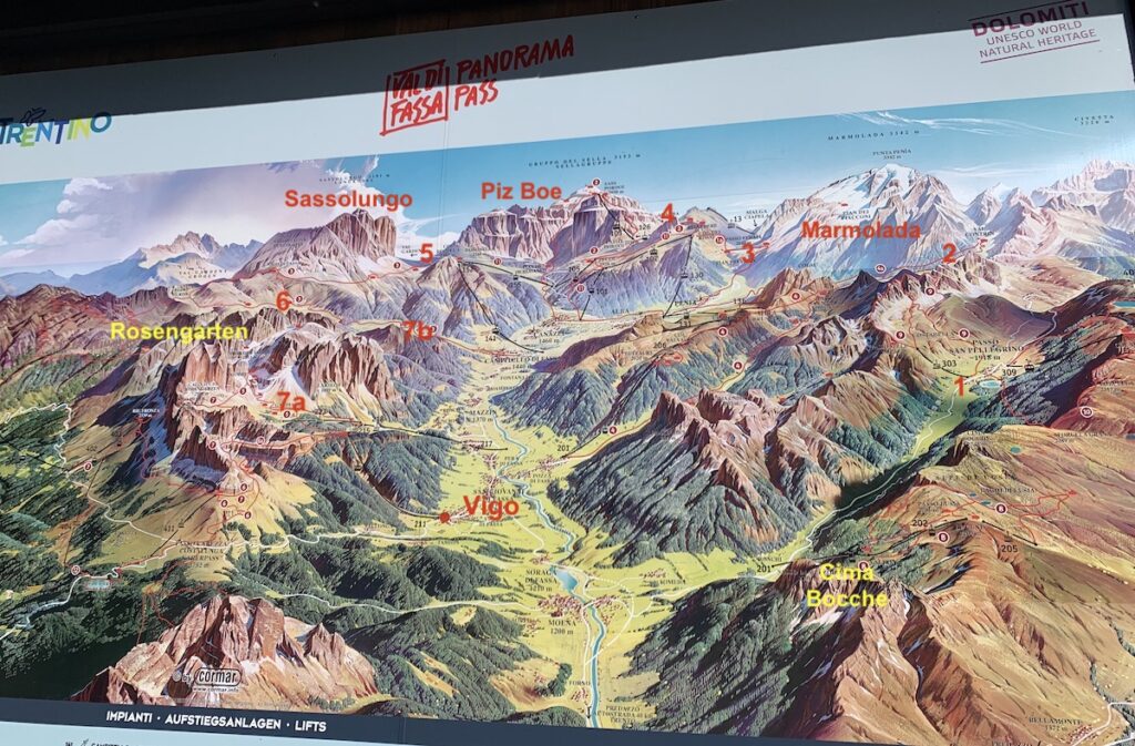
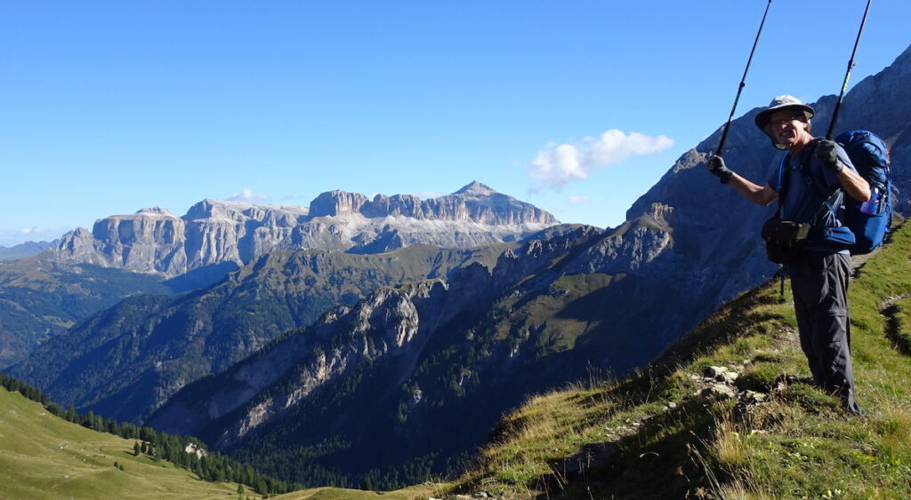
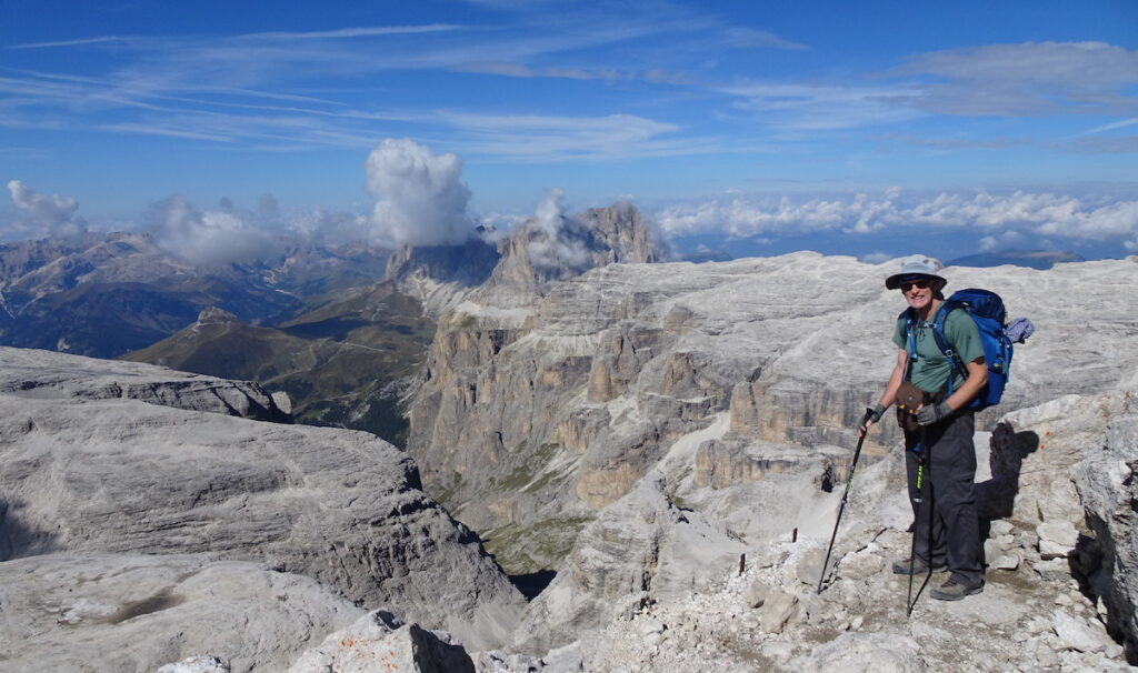
I took a photograph of this map displayed in the small town of Vigo di Fassa where we started and ended our trek. This view is northward along the Fassa Valley, which turns eastward towards its upper end. The red numbers refer to the approximate locations of the refugios where we stayed on nights 1–7. Here is the itinerary. Day 1: Taxi took us to chair lift at the base of Cima Bocche, where we hiked up to the Cima (=peak) and then down to Passo San Pelligrino (1) where we stayed in the Costabella Hotel. Day 2: We hiked northward and up a steep slope to Pas de le Ciréle (pass), then down slope to Refugio Contrin in the Contrin Valley (2) at the bottom of Marmolada’s southwest face. Day 3: We hiked over the ridge south of Contrin Valley, then down to the Fassa Valley and our refugio—Dolomia—at the upper end of the valley (3). Day 4: We hiked uphill to Passo Pordoi, then upward along the south slope of Piz Boe to Refugio Kostner (4). Day 5: We hiked over the top of Piz Boe and down to Refugio Friedrich August (5) near the base of Sassolungo. Day 6:We hiked over the top of Sassolungo to Refugio Sasso Piatto (6). Day 7: On this day we had planned to hike over a mountain in the Rosengarten group to the Refugio Stella Alpina (7a). However, a thunderstorm forecast for mid-day sent us on another route down to Refugio Micheluzzi in the Duron Valley (7b). Day 8: From Refugio Micheluzzi we hiked downhill to the Fassa Valley and back to our hotel in Vigo. On days 1–6, when we were able to complete our planned hikes, we averaged 13 km/day (8 miles/day), with ascents of 750 m/day (2500 feet/day). In the upper right corner, we are reminded that the Dolomites are a UNESCO World Natural Heritage site.Here is a northward view to Piz Boe (part of Sella group; for location see image above) as we were trekking west from Refugio Contrin (#2 on image above). Notice that Piz Boe is an isolated peak with steep sides and a flat top.Here is a view westward, two days later, from the top of Piz Boe (elevation 3152 m/10,341 feet). Again, notice the steep sides and the flat top. The next mountain to the west, with big cloud puff, is Sassolungo (for location, see image above), which we crossed the following day.
How did these beautiful white mountains form?
The name of the mountains is a big clue! The Dolomites are named after the French geologist Déodat de Dolomieu (1750–1801) who recognized an unusual carbonate rock that resembled limestone (CaCO3) but was somewhat different. Carbonates are a type of sedimentary rock that are said to be “born” not made. That is because most limestone originates as shells of animals (e.g., clams and corals) or as precipitates of various types of algae. The minerals with the chemical formula CaCO3 are calcite and aragonite. Both of these minerals effervesce when drops of weak hydrochloric acid (HCl) are applied. Dolomite is a carbonate mineral that does not effervesce so easily. This 1-minute-long YouTube video shows how to use weak HCl acid to distinguish calcite from dolomite: https://www.youtube.com/watch?v=DX6ZMPbA09U. It is now understood that in dolomite magnesium (Mg) atoms substitute for some of the calcium (Ca) atoms—its chemical formula is MgCa(CO3)2. For recognizing this different type of carbonate, Dolomieu’s name was given to the Dolomite mountains and to the dolomite mineral. What a legacy!
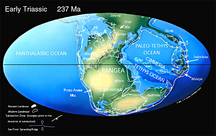
Most carbonates form in the ocean, and the rocks in the Dolomites are no exception. They were formed around 230 million years ago during the Triassic Period (Mesozoic Era), when the continents were joined together into the supercontinent called Pangea and the Tethys Ocean was located to the east of Pangea. During this time, North America began to rift away from Africa and Eurasia, and the North Atlantic Ocean began to form. As the North Atlantic has opened, the Tethys Ocean has closed, today leaving only the remnant Mediterranean Sea. Northern Italy was at the western edge of Tethys Ocean, which is where the Dolomite’s carbonate rocks were created (i.e., born!). The map is from http://www.scotese.com/newpage8.htm.
Organisms extract calcium, carbon and oxygen from sea water to create their hard parts of CaCO3. There are many factors—e.g., temperature, sea level—that control the rate of carbonate productivity. Rates are highest in shallow, warm, tropical parts of the ocean referred to as “carbonate factories”. Today, these “factories” are only small areas like the Bahamas and Great Barrier reef in coastal Australia. In contrast, during the Triassic Period, large parts of the Tethys Ocean were in favorable locations for high carbonate productivity (see Triassic map above). These rocks have since gotten caught up in the Tethyan closure and are exposed on land throughout the Mediterranean region.
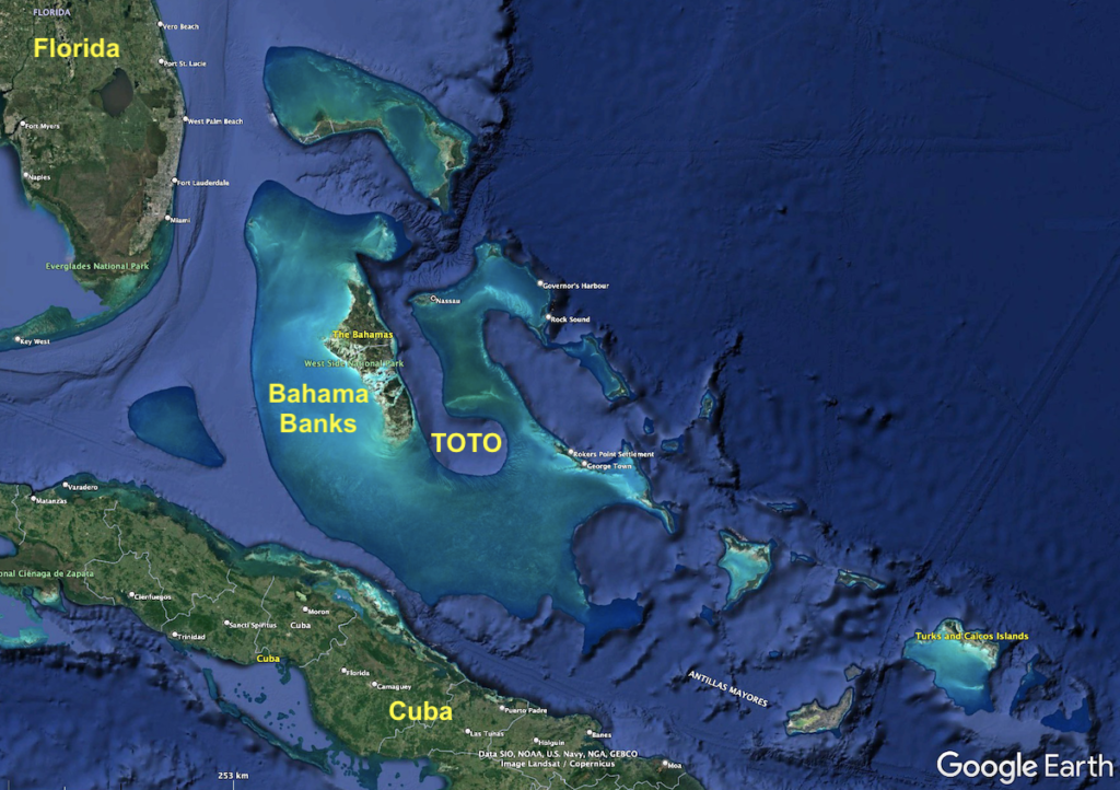
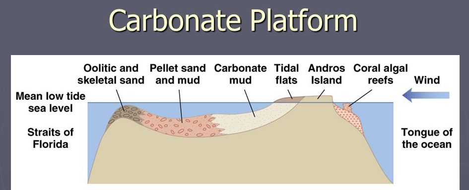
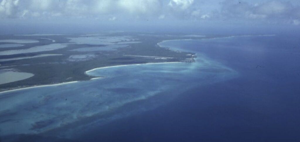
Probably the best analog for the Dolomites in today’s ocean are the Bahama Banks, located southeast of Florida and north of Cuba, as shown above. These carbonate platforms began to form in the Mesozoic Era during the opening of the Atlantic Ocean. A large variety of animals and algae secrete hard parts of calcium carbonate. As the banks slowly subside, the organisms produce sufficient carbonate sediment to keep the platforms in the photic zone. On the other hand, the seafloor adjacent to the banks is deeper than the photic zone and so it only receives sediment that falls from the platforms. For example, the Tongue of the Ocean (TOTO) is 1–3,000 m (3–10,000 feet) deep, compared to the adjacent bank at sea level.This schematic cross-section shows the relief of the Great Bahama Bank next to “the Tongue of the Ocean”. The carbonate platform is at or just below sea level, which enables organisms to thrive in the photic zone. The biggest carbonate mud producer today is penicillus algae (called “shaving-brush algae”—look it up!). Note the label “coral algal reefs”. Coral animals and coralline algae have both been long-time reef builders, although the specific species have changed through time.Here is a photo I took in the 90s, when flying into San Salvador Island, the easternmost island of the Bahama Banks. Everything is carbonate! Corals form fringing reefs on the outer part of the platform. On the platform inside the fringing reef, a large variety of animals and algae make their hard parts from calcium carbonate that breaks apart to form sediment when the organisms die. On land, the wind blows carbonate sediment produced in the water into dunes. The platform’s edges slope steeply into deep water.
Now look at the Dolomite photographs above and imagine that these carbonate platforms were in ocean water like the platforms in the Bahamas today. All that’s needed is to drop sea level, or to lift the land up out of the sea, and the individual platforms are left high and dry! [Hint: it was uplift.]
Fossils in the Dolomites
Depending on the ocean’s chemistry, most carbonate-secreting organisms make their hard parts from calcite or aragonite (CaCO3). So where did the Mg come from? We rarely see dolomite forming today, and although it could have been more common in ancient oceans, it’s believed that most of the dolomite formed as a secondary process (called diagenesis), when Mg-rich seawater flowed through the sediments and replaced the calcite or aragonite with dolomite. This process has been observed along the edges of carbonate platforms today. Some of the rocks in the Dolomites are still limestone, as the replacement process was not complete. Nevertheless, most of the rocks have been recrystallized.
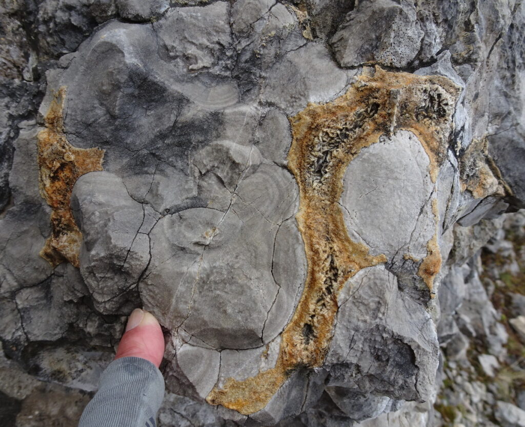
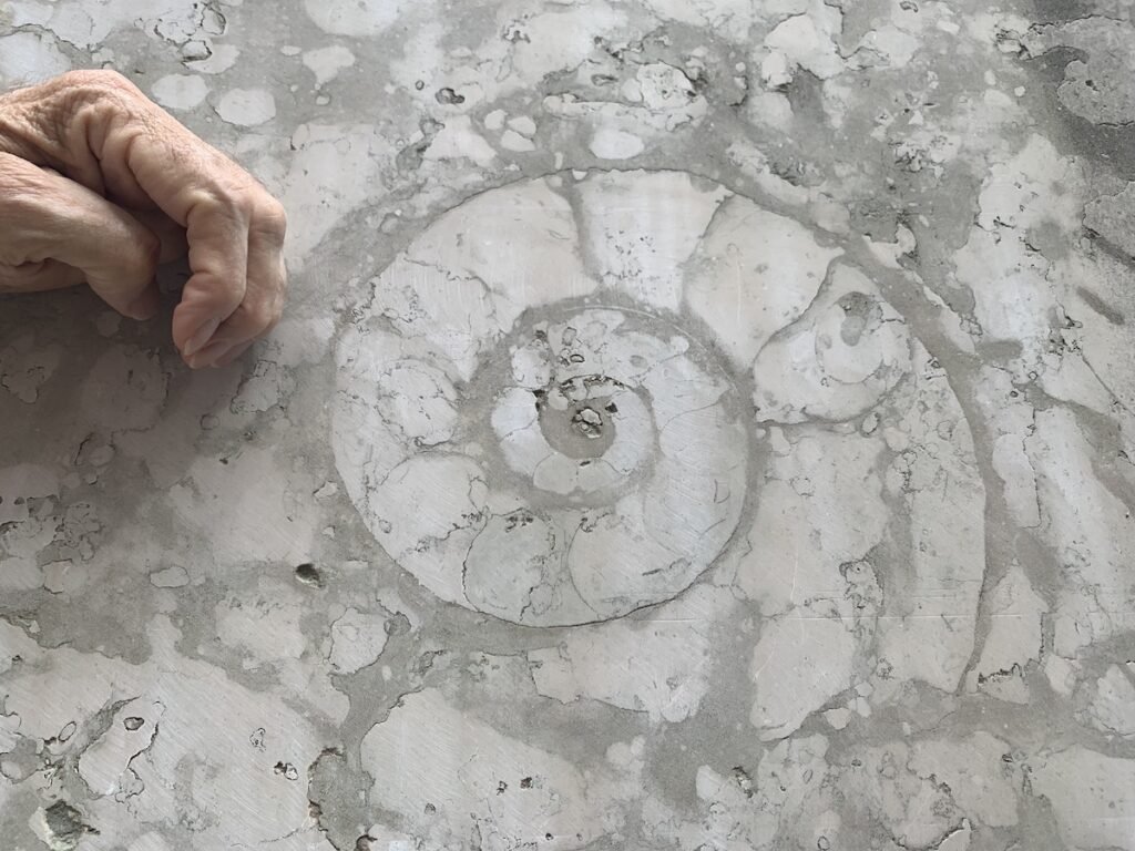
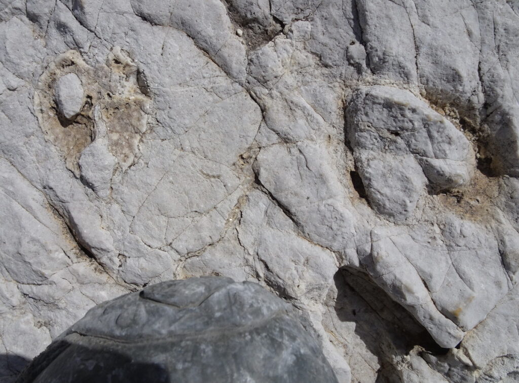
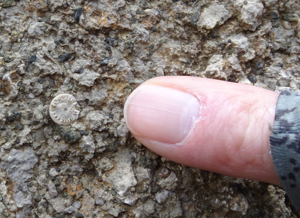
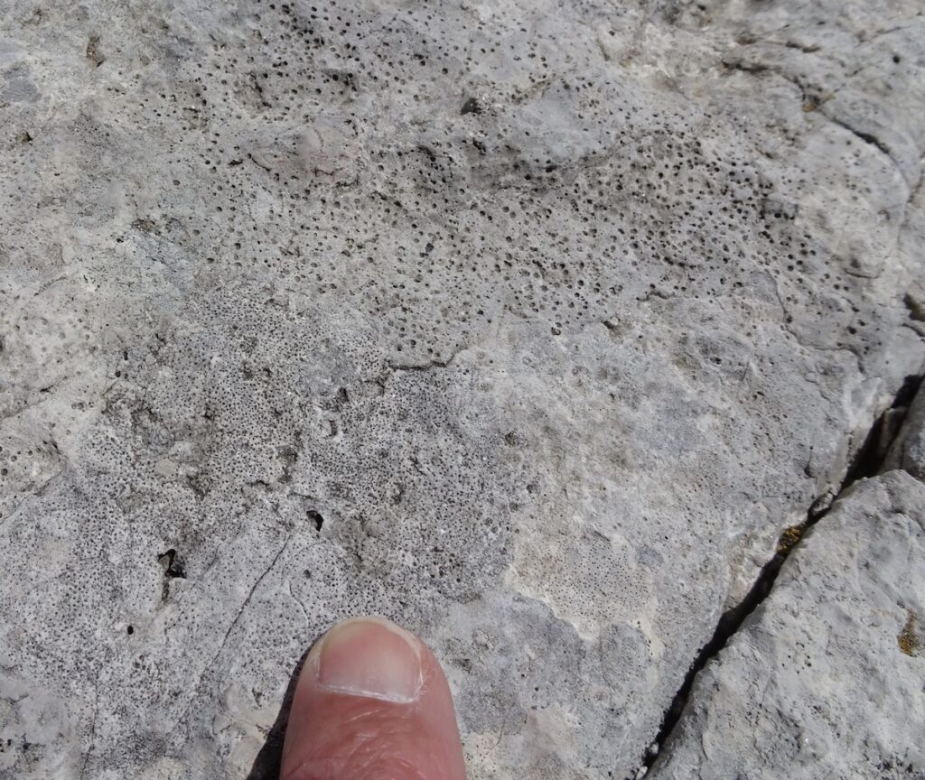
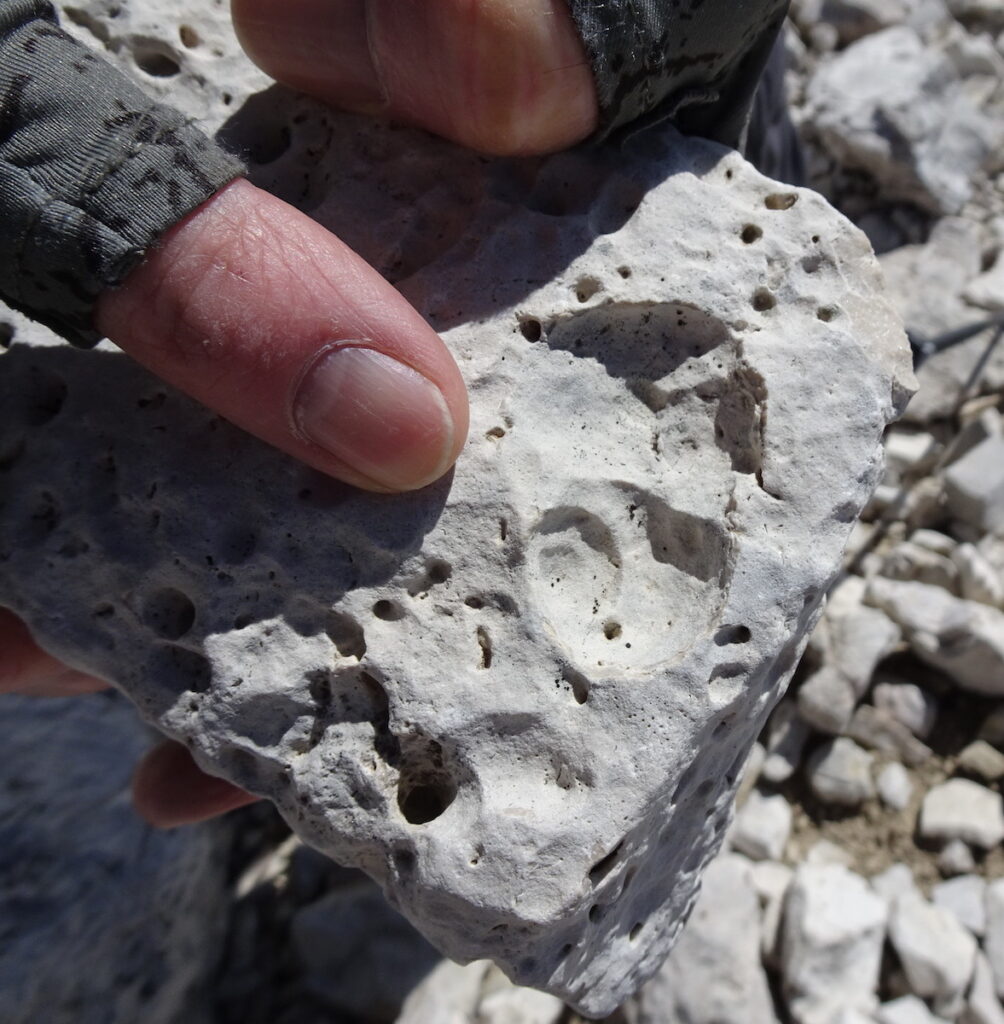
Since the Dolomites are remnant hard parts of organisms, we were continually looking for fossils during our trek. The rocks’ recrystallization makes it difficult to find specific organisms, but here are a few we could identify. Top row, left to right: microbial (algal) mats that are rolled with secondary crystals between the rolled mats; an ammonite whose only living relative is the chambered nautilus; heart-shaped clam shells (my shoe tip for scale). Bottom row, left to right: solitary coral; encrusting (coralline-type) algae; mold of a snail.
Although recrystallization has obscured the fossil shapes, it has made the rocks more resistant to chemical weathering and erosion. Rain water is slightly acidic and more easily dissolves limestone than dolomite (see video link above that shows how to distinguish calcite and dolomite). As the mountains were uplifted, the surrounding rocks were removed and the more resistant dolomite peaks remain.
Refugios and views
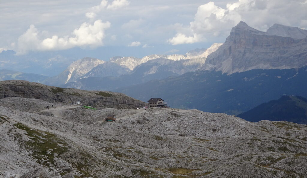
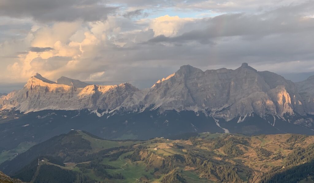
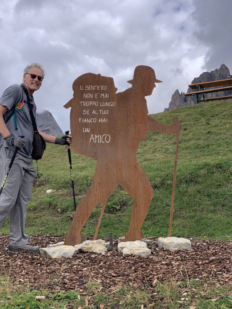
Refugio Kostner was our favorite refugio because of its remote location far from roads or chair lifts. The view is southeastward toward the eastern Dolomites.This photo (looking south) was taken at sunset from Refugio Kostner. And it’s back to the mountains near our starting and ending point in Vigo di Fassa. Before starting our 8-day trek, we hiked up to the ridge top at Ciampedie and got this view westward toward the Rosengarten group and the Vajolét pass—an appropriate introduction to the spectacular oceanic rocks we’d be immersed in for 8 days. A sign we saw there well summarized the benefits of trekking with your life’s partner and fellow geologist through nature’s wonderland: “The path is never too long if you have a friend by your side.”
They are gorgeous mountains. Thanks for posting all of your adventures.
Landscapes Revealedon October 8, 2022 at 11:33 pm
Thanks for reading Kim!
John Monteverdion October 9, 2022 at 10:27 am
Interesting geologic details on this spectacular mountain range. Tim and I visited the area several years ago. It’s one of our favorites. But, I have to say, we enjoyed it more lazily in the comfort of several wonderful hotels, with day trips. Thanks for putting the effort to create this wonderful account.
Landscapes Revealedon October 9, 2022 at 12:57 pm
A great thing about the Dolomites is that it can be enjoyed at many activity/comfort levels. I must say that the refugios were quite comfy. We had a private room each night and delicious dinners with primi/secondi/dolci/vino. Thanks for reading!
What incredible hikes you two had, and photos that will bring you miles of memories! I focused more on the Apennines in my Italian wine studies thus enjoyed reading about the Dolomites. I will take Mark to Alto Adige and would love to do even just one of your hikes!
Landscapes Revealedon October 24, 2022 at 12:49 pm
There are so many hiking choices in the Dolomites! We appreciated your blogs about northern Italian wines while we were there.
Annie Havekoston November 3, 2022 at 11:21 am
Hi Karen! So great to see what you have been up to! I love the post and can’t wait to see the Dolomites one day. Hugs, Annie
Landscapes Revealedon November 3, 2022 at 11:44 am
So good to hear from you Annie! Glad you enjoyed the post!


They are gorgeous mountains. Thanks for posting all of your adventures.
Thanks for reading Kim!
Interesting geologic details on this spectacular mountain range. Tim and I visited the area several years ago. It’s one of our favorites. But, I have to say, we enjoyed it more lazily in the comfort of several wonderful hotels, with day trips. Thanks for putting the effort to create this wonderful account.
A great thing about the Dolomites is that it can be enjoyed at many activity/comfort levels. I must say that the refugios were quite comfy. We had a private room each night and delicious dinners with primi/secondi/dolci/vino. Thanks for reading!
What incredible hikes you two had, and photos that will bring you miles of memories! I focused more on the Apennines in my Italian wine studies thus enjoyed reading about the Dolomites. I will take Mark to Alto Adige and would love to do even just one of your hikes!
There are so many hiking choices in the Dolomites! We appreciated your blogs about northern Italian wines while we were there.
Hi Karen! So great to see what you have been up to! I love the post and can’t wait to see the Dolomites one day. Hugs, Annie
So good to hear from you Annie! Glad you enjoyed the post!