Plate tectonics 101—What happens when plates slide past each other?
January 16, 2021
Oceanic crust is created at divergent plate boundaries and destroyed at convergent boundaries, but transform boundaries cause neither; rather, they transform motion between other types of plate boundaries, enabling plates to move about efficiently on our spherical planet. In this post, we will explore various examples.
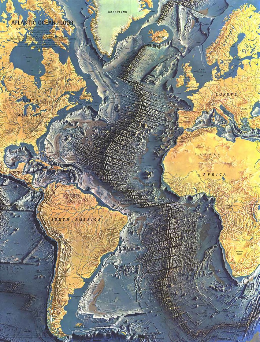
The majority of transform boundaries are found in the ocean, where they separate segments of the mid-ocean ridges, as shown in the map of the Atlantic ocean floor above. This map was both a scientific breakthrough and an artistic achievement. Marie Tharp, a geologic and oceanographic cartographer, painstakingly used ship soundings to create bathymetric (depth) profiles across the ocean. She and her colleague Bruce Heezen stunned the scientific community in the 1950s when they first shared their maps, which revealed a much more complex ocean seafloor than was previously imagined. Their map revealed continental shelves and slopes (areas adjacent to coastlines that are actually parts of continents), abyssal (deep) plains, and mid-ocean ridges, among other features. The map above (ICA web site) was published by the National Geographic in 1968. It was painted by Heinrich Berann, based on Tharp and Heezen’s work. A map of the entire world ocean was published in 1977 (see University of Chicago web site).
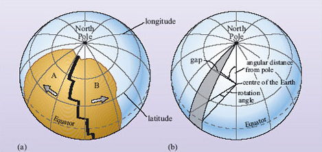
Since tectonic plates are not flat—they collectively form the surface of our spherical planet—their movements are best described as rotations around a pole (Euler geometrical theorem). The image on the left (a) shows the geometry of an example plate boundary where plates A and B are diverging from a mid-ocean spreading ridge with segments that are separated by transform faults (thick black line). The image on the right (b) shows the geometrical relationships used to describe plate movements around a pole of rotation. While the rotation angle remains the same along the length of the separation (gap on the image), the width of the separation increases with angular distance from the pole of rotation—in this case the North Pole. The transform faults are great circles around the pole of rotation; since in this example the pole of rotation is the North Pole, the transform faults are parallel to lines of latitude, as in image (a). Since the plates spread apart faster with increasing distance from the rotation pole, as in image (b), transform faults are what enable the different segments of the ridge to move at different rates. Images are from OpenLearn web site.
This diagram illustrates the details of oceanic transform faults—the faults between two mid-ocean ridge segments. Note that the transform fault separates two different plates that are moving in opposite directions. However, over time, the transform faults evolve into fracture zones—”fossil” faults—once they have moved far enough away from the mid-ocean ridge that they are separating the same plate, so the seafloor is moving in the same direction, and a fault is no longer needed. In the map above, we can now see that most of the east–west lines on the seafloor are actually fracture zones—extinct transform faults that were active when they were located between ridge segments. Diagram is from a Pearson Education textbook.
There are also many transform plate boundaries on land that connect between various types of plate boundaries—the most famous being the San Andreas fault in California.
The San Andreas fault (purple line with yellow arrows) is a ~1370 km (~800 mile)-long transform fault that is part of the western boundary of the Pacific plate. It connects the nascent oceanic spreading ridge in the Gulf of California to the south—note transform faults separating ridge segments—and the Cascadia subduction zone to the north. The northern connection is called the Mendocino Triple Junction because it is where three plates come together: the North American, Pacific and Juan de Fuca plates. The Mendocino Transform is the third leg of the plate boundary trio. It connects to the Juan de Fuca spreading ridge, where the Juan de Fuca plate is diverging from the Pacific plate. There is another triple junction—Rivera—at the south end of the map that is the junction among the North America, Pacific, and Cocos plates. The map is from a National Park Service web site.
The San Andreas transform is also known as a strike-slip fault, so called because the movements are horizontal rather than vertical. This particular type of strike-slip fault is right-lateral—if you stand on one side of the fault and look across it, the land on the other side is moving to the right. This is true no matter which side of the fault you stand on. The San Andreas fault was “born” about 7 million years ago, when the Pacific plate boundary “jumped” inland and captured a part of western North America. This is also when the Gulf of California began to open. All of the land west of the gulf and the San Andreas fault is moving to the northwest relative to the North American plate on the east side of the fault.
Many features have been used to measure the total amount of offset along the San Andreas fault. The best known is the offset between the Pinnacles Volcanics on the west side of the fault and the Neenach Volcanics, located 320 km (190 miles) to the south on the east side of the fault. In 1973, Vincent Matthews recognized that these volcanic fields were the same age (~23 million years old) and made of the same igneous rock types, and he surmised that the Pinnacles field had moved hundreds of km to the north since the San Andreas formed seven million years ago. Measured offsets of many other features have since confirmed his conclusion.
This right-lateral motion continues whenever there is an earthquake on the San Andreas fault. The 1906 Great San Francisco earthquake (M 7.9) has been the largest historic earthquake on the San Andreas fault, although an earthquake in 1857 on the southern end of the San Andreas was probably nearly as large. The 1906 event was pivotal in that scientists realized for the first time that earthquakes occur as a result of movement on faults. Of course, they did not yet know the significance of the fault in its larger plate tectonic context. That would come decades later when, in 1970, Tanya Atwater (UC Santa Barbara professor) published a landmark paper explaining how geological observations in California and throughout the West Coast could be explained by plate tectonics. To learn more about the fault and the 1906 earthquake, refer to my November 6, 2020 post about Point Reyes National Seashore, which is where the greatest amount of offset (~7 m / ~20 feet) was measured following the 1906 earthquake. This USGS web site contains additional information about that earthquake.
In divergent plate boundaries, valleys are created where faults cause the land to drop down, and mountains are created (e.g., mid-ocean ridges) because of high heat flow. In convergent plate boundaries, mountains are created by building volcanoes and by compression that causes the land to lift up, sometimes to very high elevations. But transform boundaries, because the motions are horizontal rather than vertical, do not usually create much topography. There are some exceptions, however, notably the Big Bend in the San Andreas fault.
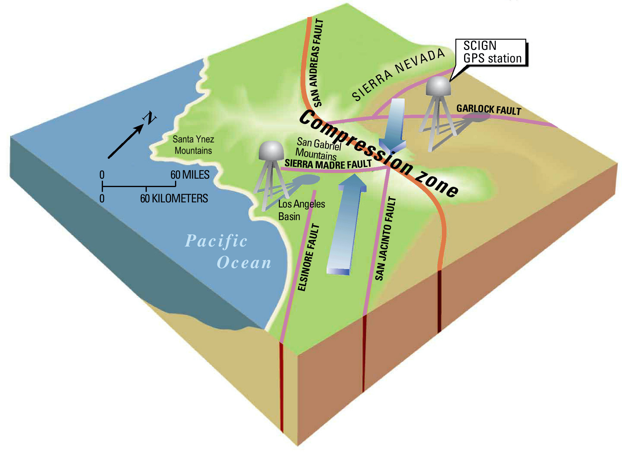
If you examine the two maps of the San Andreas fault above, you will see that there is a bend in the fault north of Los Angeles. This bend developed because of complex interactions within a large system of faults in southern California. The generalized map above shows the effect of the bend, which causes the two plates to move toward each other—like a miniature convergent plate boundary—rather than simply slide past each other. The resulting compression has created large mountains north of the Los Angeles Basin—from the San Gabriel Mountains north of Los Angeles to the Santa Ynez Mountains north of Santa Barbara. Map is from Southern California Earthquake Center web site. A bend in the opposite direction would produce a small area of extension—a miniature divergent plate boundary.
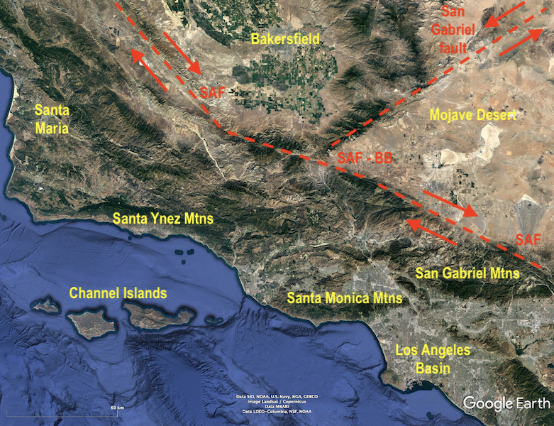
This Google Earth map shows the actual geography of the Big Bend area. SAF=San Andreas fault; BB=Big Bend part of the fault; red arrows show sense of fault motion. Unlike the right-lateral San Andreas, the San Gabriel fault is a left-lateral transform fault. The east–west-oriented mountain ranges in southern California (e.g., Santa Ynez Mountains north of Santa Barbara; Santa Monica and San Gabriel Mountains north of Los Angeles) are referred to collectively as the Transverse Ranges. They have this orientation because they have been caught in a compressive vice caused by the bend in the SAF. The offshore Channel Islands, and the San Bernadino Mountains (east of the San Gabriel Mountains and the SAF) are also part of the Transverse Ranges.
Next we’ll examine some large-scale examples of how transform faults connect among other types of plate boundaries. Keep in mind that the configuration of plates is continually evolving and that the geometry of plates on a sphere produce stresses (forces) that plates must “figure out” how to respond to.
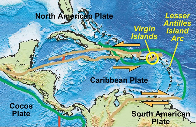
One example is the Caribbean plate, where large transform faults form the northern and southern boundary of a plate that is moving eastward relative to North America (to the north) and South America (to the south). The green lines are subduction zones where oceanic plates are descending beneath the Caribbean plate—the Cocos plate on the western side and the South American plate on the eastern side. The volcanic chains along the west coast of Central America and that make up the Lesser Antilles are products of these subduction zones. The transform boundaries connect between these two subduction zones and enable the Caribbean plate to move eastward. The map is from a National Park Service web site. The red lines are oceanic spreading ridges.
Another interesting example is the Anatolian plate (most of Turkey), which is in a vice grip between the converging Arabian and Eurasian plates. This scenario is part of the on-going closure of the once-large-sized Tethys Ocean that has produced the collisions that resulted in the Alps and the Himalaya Mountains. The Bitlis-Zagros Fold and Thrust Belt is a collision zone that is forcing the Anatolian plate to squeeze westward (yellow arrow pointing toward the Hellenic Arc) along the North and East Anatolian (transform) faults. Imagine that the faults are your fingers that are squeezing the Anatolian plate westward like a pumpkin seed—this process is referred to as “escape tectonics”! The map is from a wikipedia web site.
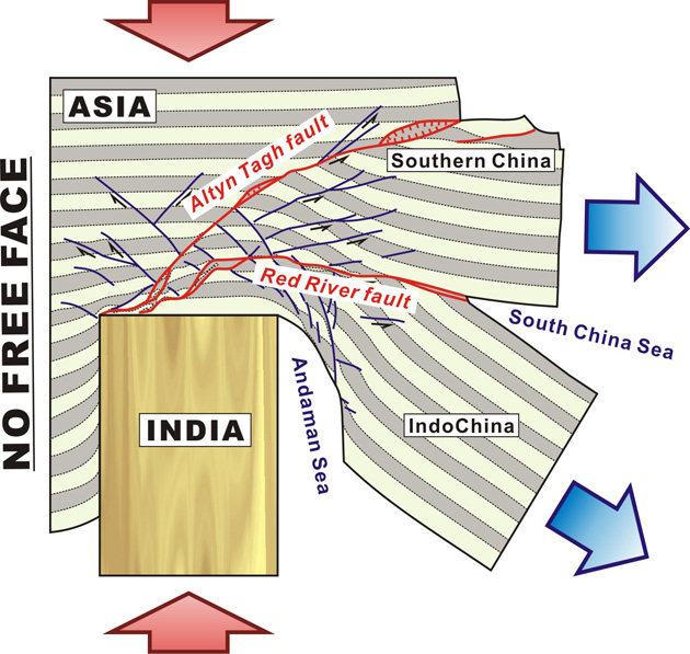
An even more dramatic example of escape tectonics is where the sub-continent of India has been colliding with southern Asia. This image (from a research article) is an experimental model to illustrate how Southern China and IndoChina are “escaping” (blue arrows) to the east in response to the north–south compression (red arrows) caused by the continental collision. India has been acting as an “indenter” that keeps pushing northward, in the process crumpling southern Asia, uplifting the Tibetan Plateau, and initiating transform faults (e.g., Altyn Tagh and Red River) that enable eastward motion away from the zone of compression.
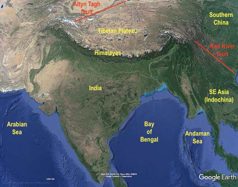
This Google Earth map shows the actual areas involved in this “tectonic escape” scenario. Notice how India is literally pushing far northward into southern Asia, which is forcing Southern China and SE Asia (i.e., Cambodia, Laos, Myanmar, Malaysia, Thailand, and Vietnam) eastward and southward along transform faults such the Altyn Tagh and the Red River.
In conclusion, we can see that plate boundaries are complex entities, and transform faults, in particular, are often found associated with both divergent and convergent types of plate boundaries. Much of the complexity is because these rigid plates are moving around on a spherical surface, so geometric instabilities often arise, especially at the junctions among plates, such as the Mendocino triple junction in northern California. There are many earthquakes near this triple junction because the geometry of these three intersecting plates is creating a small zone of compression and uplift. The Mendocino triple junction is expected to continue migrating northward—in 10 million years it will probably be located due west of Ashland, Oregon, where I currently live. It will then be called the Brookings triple junction!
Isn’t it amazing that only 50 years ago the similarities of Pinnacles Volcanics and the Neenach Volcanics were recognized and put into context? I wonder what geo-scientists in 50 years from now will consider as common knowledge and ask themselves: Isn’t it amazing that these guys in 2020 did not see that?


Isn’t it amazing that only 50 years ago the similarities of Pinnacles Volcanics and the Neenach Volcanics were recognized and put into context? I wonder what geo-scientists in 50 years from now will consider as common knowledge and ask themselves: Isn’t it amazing that these guys in 2020 did not see that?
Indeed! It seems the real frontier now is getting more data from Earth’s interior, since that’s what’s driving the action.