Plate tectonics 101—what happens when plates move toward each other?
January 8, 2021
When plates move away from each other (divergent boundaries; see last post on December 31), new oceanic crust is created. Since Earth is not expanding, ocean crust must be destroyed elsewhere. This happens at convergent boundaries, where plates move toward each other. Here, oceanic crust is destroyed, or rather, it gets recycled back into Earth’s depths. The places where oceanic crust is descending back into Earth’s interior are called subduction zones. They are located underwater, where down-going plates create valleys in the seafloor called trenches—the deepest parts of the ocean. The greatest depth of 11 km (36,000 feet) is in the Marianas trench in the western Pacific.
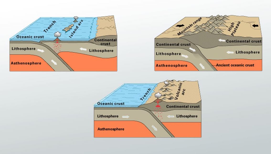
There are three types of convergent plate boundaries: oceanic crust converging with continental crust (lower image; the most common type); oceanic crust converging with oceanic crust (upper left image; most are found in the SW Pacific); continental crust converging with continental crust (upper right image). For simplicity, I am referring to “crust”, but note that it is really the lithosphere, which includes the crust and the upper part of the underlying mantle. The solid rigid lithospheric plates move over the asthenosphere, which is also solid but soft and malleable (think of toothpaste) because it is so hot (asthenes=weak in Greek, whereas lithos=rock in Greek). Diagrams from: https://pubs.usgs.gov/gip/dynamic/understanding.html.
You might ask—why does oceanic crust always lose? That is, why is it always the part of lithospheric plates that goes back into Earth’s interior, whereas continental crust stays at Earth’s surface? The answer is density. Oceanic crust is made of igneous rock with minerals rich in iron and magnesium that are nearly twice as dense as the rock in continental crust, with minerals more rich in silica and aluminum. You may wish to view my post about Yellowstone National Park. At the bottom of that post is a diagram to show the different types of igneous rocks. Continental crust is mostly made of silica-rich rocks like granite, whereas oceanic crust is mostly made of silica-poor rocks like basalt and gabbro. The denser rocks of oceanic crust is also why the ocean basins are deep; in contrast, the less-dense rocks of the continents “float” at higher levels over the asthenosphere.
Let’s look at earthquake and volcano data that provide important evidence for the locations of convergent plate boundaries.
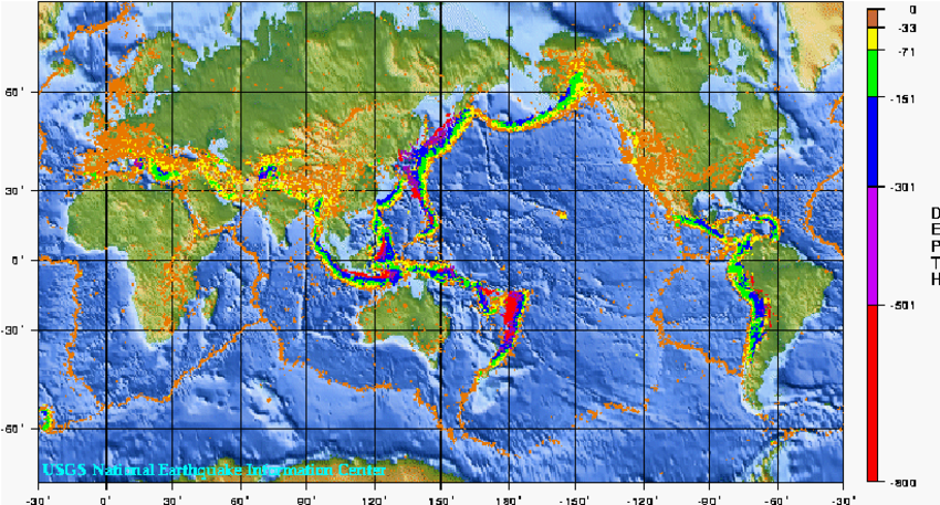
This map shows the epicenters of global earthquakes from 1975–1995. Earthquakes occur beneath Earth’s surface at places called foci (or hypocenters). Two-dimensional maps show these locations as epicenters (points on Earth’s surface directly above the focus) that are color-coded to reveal depth (in km). We can easily locate convergent plate boundaries because they are the only places on Earth where deep earthquakes (>70 km/42 miles; shown in green, blue, purple and red colors above) can occur. These depths in Earth’s interior are too hot for forces to build up enough to cause earthquakes. However, in subduction zones, oceanic lithosphere retains its hard, brittle physical properties even after it has slipped hundreds of km into Earth’s interior. It is only in hard, brittle rock that forces can built up sufficiently to cause earthquakes. Imagine putting pressure onto a pencil, which yields only after some time of applying pressure. That yielding, i.e., breaking, is analogous to an earthquake. In contrast, imagine putting pressure on a weak solid like toothpaste, which yields immediately so it is not possible to build up pressure and break.
Most of the deep earthquakes are around the edges of the Pacific Ocean, where most of the convergent-type plate boundaries are found. These boundaries are of two types: oceanic crust subducting beneath continental crust (e.g., west coast of South and Central America), and oceanic crust subducting beneath oceanic crust (e.g., many of the island chains in the SW Pacific). There are no convergent boundaries in the Atlantic Ocean, except where the small Scotia plate, located between South America and Antarctica, is pushing eastward over oceanic crust. The mid-ocean ridges are “outlined” by earthquakes that are at shallow depths because the lithosphere there is very thin. These earthquakes are also relatively small—on ridge segments they don’t exceed magnitude 5.5, although earthquakes up to magnitude 7 have been observed on transform boundaries that separate mid-ocean ridge segments.
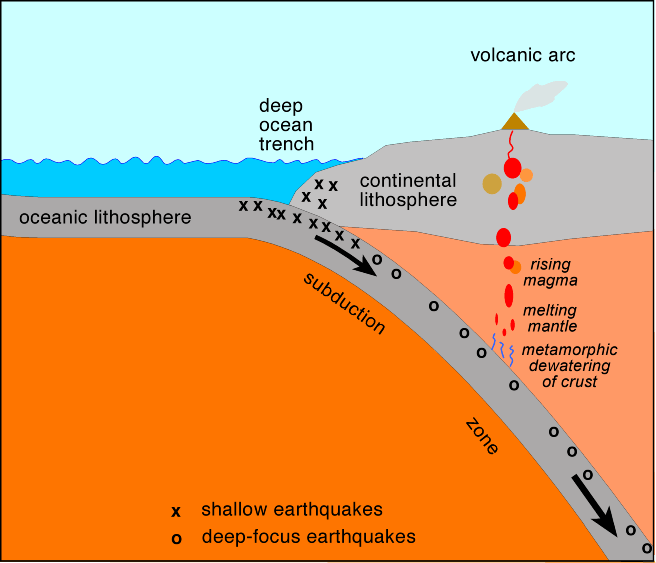
This profile view of a subduction zone in an ocean–continent-type convergent boundary shows the locations of deep-focus earthquakes. This descending zone of oceanic lithosphere, where active earthquakes can occur, is called the Wadati-Benioff zone, after the two seismologists who discovered this. Diagram from http://www.columbia.edu/~vjd1/subd_zone_basic.htm.
The insertion of rigid oceanic crust into Earth’s interior at subduction zones enables deep earthquakes to occur and causes chains of volcanoes to be created parallel to the subduction zones. Volcanoes occur because watery oceanic sediments overlying the down-going oceanic crust lower the melting temperature of mantle rock and cause liquid rock (i.e., magma) to rise (see subduction zone profile above). Some of that rising magma cools in plutonic bodies beneath Earth’s surface and some of the magma rises all of the way to the surface and is erupted at volcanoes. My blog post about Rogue Valley geology has a diagram that shows how magma cools underground to form plutonic rocks and how it rises to the surface to form volcanic rocks. Because the edges of the Pacific Ocean are mostly convergent plate boundaries, with deep earthquake and chains of volcanoes, the Pacific Ocean is often referred to as the “Pacific Ring of Fire”. Diagram from https://www.britannica.com/place/Ring-of-Fire.
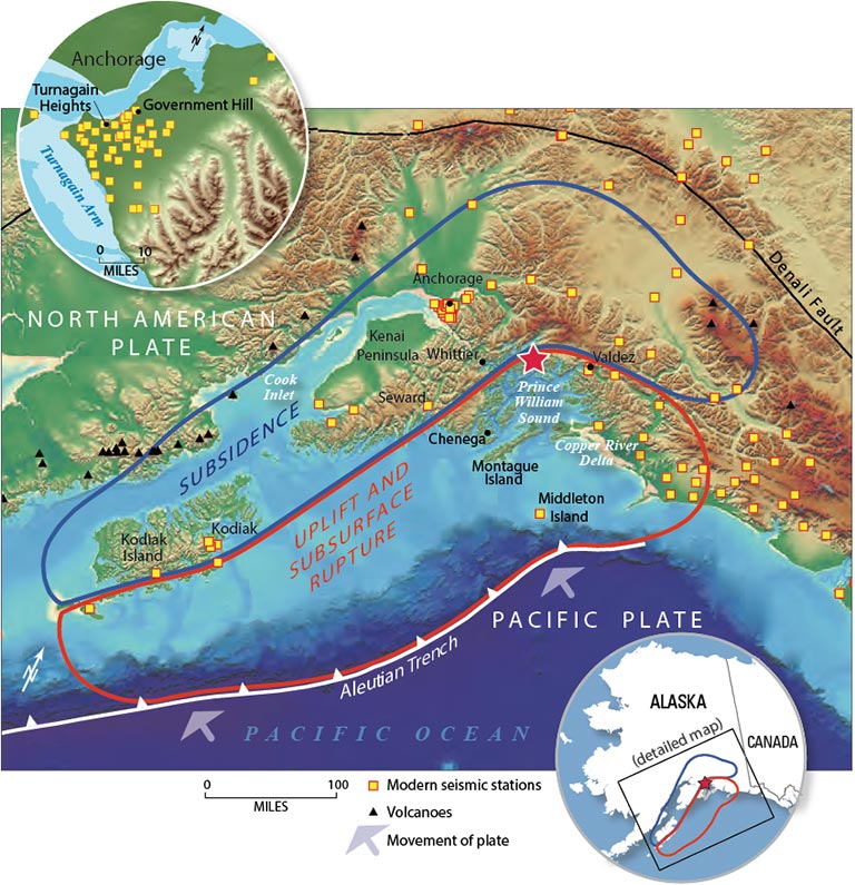
How were these subduction zones discovered? Coincidentally, the two largest earthquakes ever recorded by instruments occurred during the 1960s, when geoscientists were in the process of figuring out the basics of plate tectonics. The largest occurred first (1960 Chilean earthquake), but it was the second largest (1964 Alaskan earthquake) that led to the initial discovery of the subduction process.
In March 27, 1964, the magnitude 9.2 Great Alaskan (also called the Good Friday) earthquake ruptured an area 800 km (500 miles) long (area shown in red on the map). As luck would have it, a group of U.S. Geological Survey geologists were doing field work in Alaska when the earthquake occurred. One geologist, George Plafker, carefully studied the pattern of destruction and proposed that the earthquake was a result of movement of the Pacific (oceanic) plate toward and beneath the North American (continental) plate on what he called a “mega-thrust”. We now know that in the Aleutian trench (a subduction zone), the Pacific plate is converging with the North American plate at a rate of ~60 mm/yr (2.5 inches/year). Map from https://earthquake.usgs.gov/earthquakes/events/alaska1964/. This site also contains many interesting videos and images about the earthquake.
After studying evidence from the Alaskan earthquake, George Plafker traveled to Chile, since he realized the Chilean earthquake just a few years earlier was also probably the result of a “mega-thrust” earthquake in what we now recognize as the subduction zone where the Nazca (oceanic) plate is descending beneath the South American (continental) plate. He carefully mapped the coastal region and found a pattern similar to what had been observed in Alaska—seaward areas where the land had been uplifted (red area in the map above) and landward areas where the land had sunk (i.e., subsided).
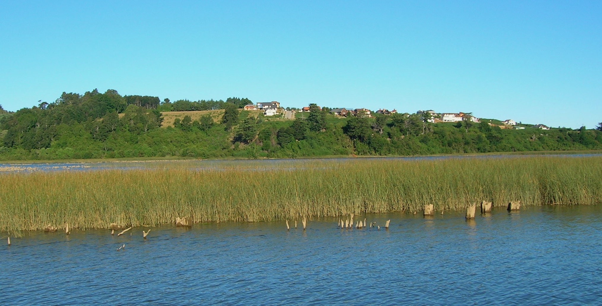
Forty-six years after the 1960 Chilean event, we visited Valdivia, a coastal town near the earthquake’s epicenter, where we could still see evidence of subsidence. Note the tree trunks, in front of and behind the grass strip, that are remnants of trees that died when the land sank into the water and the trees could no longer survive. Similarly, tree trunks have been observed along the coast of Oregon and Washington, where trees were inundated during the subsidence that occurred during the last major Cascadian subduction earthquake in 1700, before we had instruments to record its magnitude.
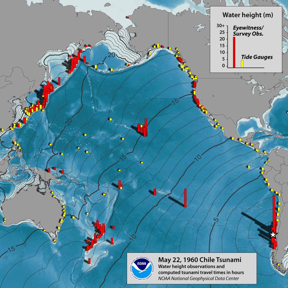
Another hallmark of subduction zones is tsunamis, large waves that threaten locations around the Pacific Ocean following subduction-zone earthquakes. This map shows how the Chilean earthquake created large waves at locations around the Pacific, including Hawaii (cluster of red columns in the middle of the ocean), where the tsunami caused 61 deaths, 43 injuries, and $23.5 million in damage. The numbers on the seafloor are the number of hours it took for the tsunami to travel across the Pacific. Even in Japan, where the tsunami arrived ~24 hours after the earthquake, the tsunami caused 139 deaths and destroyed almost 3,000 homes. Because of the potential danger, the Pacific Tsunami Warning System was established in 1949, after a tsunami generated in the Aleutian trench devastated Hilo, Hawaii. The center, located in Hilo, sends a warning whenever earthquakes occur in the circum-Pacific region. Diagram and data from https://www.ngdc.noaa.gov/hazard/22may1960.html.
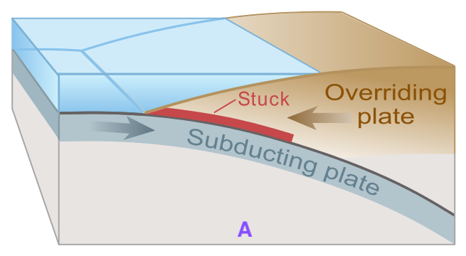
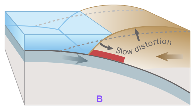
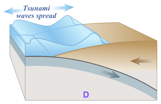
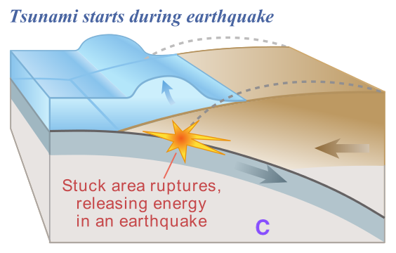
These images show how to generate a tsunami. A) Forces build up as oceanic (subducting) and continental (overriding) plates converge. B) As pressure builds up, there is slow distortion that uplifts the continental plate. C) Pressure exceeds strength of the fault, which slips to create an earthquake. The overriding plate subsides on-land (e.g., blue area in map of Alaska above) and is pushed seaward (e.g., red area in map of Alaska above), creating an underwater impulse that generates waves (think of pushing on the sides of a plastic swimming pool). D) The generated waves move across the ocean at a rapid rate of ~800 km/hr (500 mph)! Tsunami is a Japanese word for “harbor wave”, named this because the waves can travel through ocean water unnoticed until they reach shallow water (e.g., in a harbor), where they quickly increase in height and can have the potential to carry ocean water far inland. Recently, we have seen highly damaging tsunamis generated by the 2004 Indian Ocean earthquake (M 9.1—the third largest recorded earthquake, on the subduction zone off the west coast of Sumatra) and the 2011 Japanese earthquake (M 9.0, on the subduction zone off the east coast of Japan). Diagrams are from https://en.wikipedia.org/wiki/Tsunami.
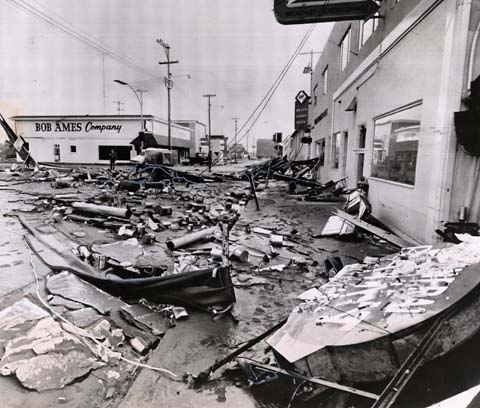
In the continental U.S., the greatest amount of tsunami damage was suffered by Crescent City, a small coastal town in northern California, after the 1964 Alaskan earthquake. The configuration of its coastal location and the geometry of its harbor make it particularly vulnerable to earthquake-generated oceanic waves. The photo above, of the Crescent City waterfront, is from a SFGATE.com article that also contains many post-earthquake photos from Alaska. Attention was focused anew on Crescent City after a Southern Oregon University (SOU) professor, Dennis Powers, in 2005 published a book about the 1964 tsunami entitled “The Raging Sea”. This NPR piece contains some of the eye-witness accounts extracted from Powers’ book.
From the evidence presented above, we can see that convergent plate boundaries are the most dangerous types—they cause the largest earthquakes, they create active volcanoes, and they generate tsunamis that can travel for long distances away from the plate boundaries. But they also create some of Earth’s most beautiful landscapes. For example, you may wish to visit some of my previous blog posts about the Cascadia subduction zone and its associated chain of Cascade volcanoes: Crater Lake, South Sister volcano, Lassen Volcanic National Park, and Mt. St. Helens.
The third type of convergent plate boundary—the convergence of two continents—creates what could be considered the most spectacular landscapes of all. The Himalayas, the highest mountains on our planet, and the Alps in southern Europe are both the results of continental collision.
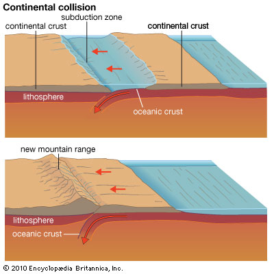
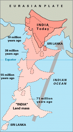
Continents collide when the oceanic part of a plate gets completely subducted and the continental part of a plate then encounters another continent, as shown on the left-side diagram. Because continental crust is less dense than oceanic crust, it is more buoyant and can’t be subducted. So, like two male elephant seals in battle, the two continents “face off” and collide with each other, in the process making mountains that rise to high elevations. The right-side map (from USGS.gov) shows how the sub-continent of India has moved northward during the past 71 million years to finally ram into the southern edge of the Eurasian plate to create the Himalayan Mountains. Seventy million years ago, India was part of a plate with oceanic crust on the northern part, as in the upper diagram. Once the oceanic crust was used up (i.e., subducted beneath southern Asia), the continental collision began, as in the lower diagram. That collision continues and the Himalayas continue to rise. Map from https://pubs.usgs.gov/gip/dynamic/himalaya.html.
The Alps in southern Europe are also a result of continental collision. Like the Himalayas, the Alps have been sculpted by glaciers because of their high altitudes. In my last post (December 31) there is a reconstruction of the plates about 150 million years ago that shows the Tethys Ocean. The Mediterranean Sea is the remnant of that much-larger Tethys Ocean, which has closed as the African plate has converged with the Eurasian plate to the north. Because of the irregular geometry of the continental edges, the collision has progressed irregularly, over a long period of time, starting ~65 Ma and continuing today. For example, the volcanoes in Italy are a result of currently-active subduction processes.
For more information about the geology of the Alps, you may wish to visit my posts of a trek from Chamonix to Zermott in 2019, published in September 18, September 22, and September 27. I had expected to visit the highest mountains in November 2020, but hopefully it will be possible to trek in the Himalayas in 2021—stay tuned!