Plate tectonics 101—what happens when plates move away from each other?
December 31, 2020
It’s winter in the midst of a pandemic, and travel is restricted. So it seems a good time to go back to some geologic basics, the knowledge of which are sometimes assumed in these blog posts. The next four posts will explore the essentials of plate tectonics—the underpinning of our modern geologic understanding. Plate tectonics refers to the processes that control the structure and properties of Earth’s crust and its evolution through time. The Earth is broken up into variously-sized lithospheric plates that comprise the solid, brittle outer layer of our planet; the plates move over the hot, weak asthenosphere beneath (see diagram below). As we will see, the science of geology, and our understanding of how Earth works, has been completely revolutionized during just the past 60 years—during many of our lifetimes!
We will explore Earth’s landscapes at the three types of tectonic plate boundaries—divergent (plates move away from each other), convergent (plates move toward each other), and transform (plates move past each other). Most geologic action, such as earthquakes and volcanoes, occur at these plate boundaries, but we also see active processes above “hot spots” that are often in the middle of plates, not at their edges. We will explore this scenario in the fourth post. The current post is focused on “divergent plate boundaries”, the majority of which are in the ocean and are called mid-ocean ridges (MORs). Diagram from www.usgs.gov.
As early as the 16th and 17th centuries, explorers observed that the continents on each side of the Atlantic Ocean seemed to fit together like jig-saw pieces. In the early 20th century, Alfred Wegener, a German geoscientist, proposed the idea of continental drift—that continents are moving around on Earth’s surface. His proposal was based not only on the fit of the continents, but also on his observation of similar fossils and mountain ranges now found on separated continents, and on evidence of glacial activity in rocks now found in tropical latitudes. He described a super-continent called Pangea, a name still applied to the amalgamation of the continents around 250 million years ago (see Late Jurassic reconstruction below). The problem was that no one could understand how the continents could “plow through” the ocean to move to different places, and the hypothesis was largely dismissed.
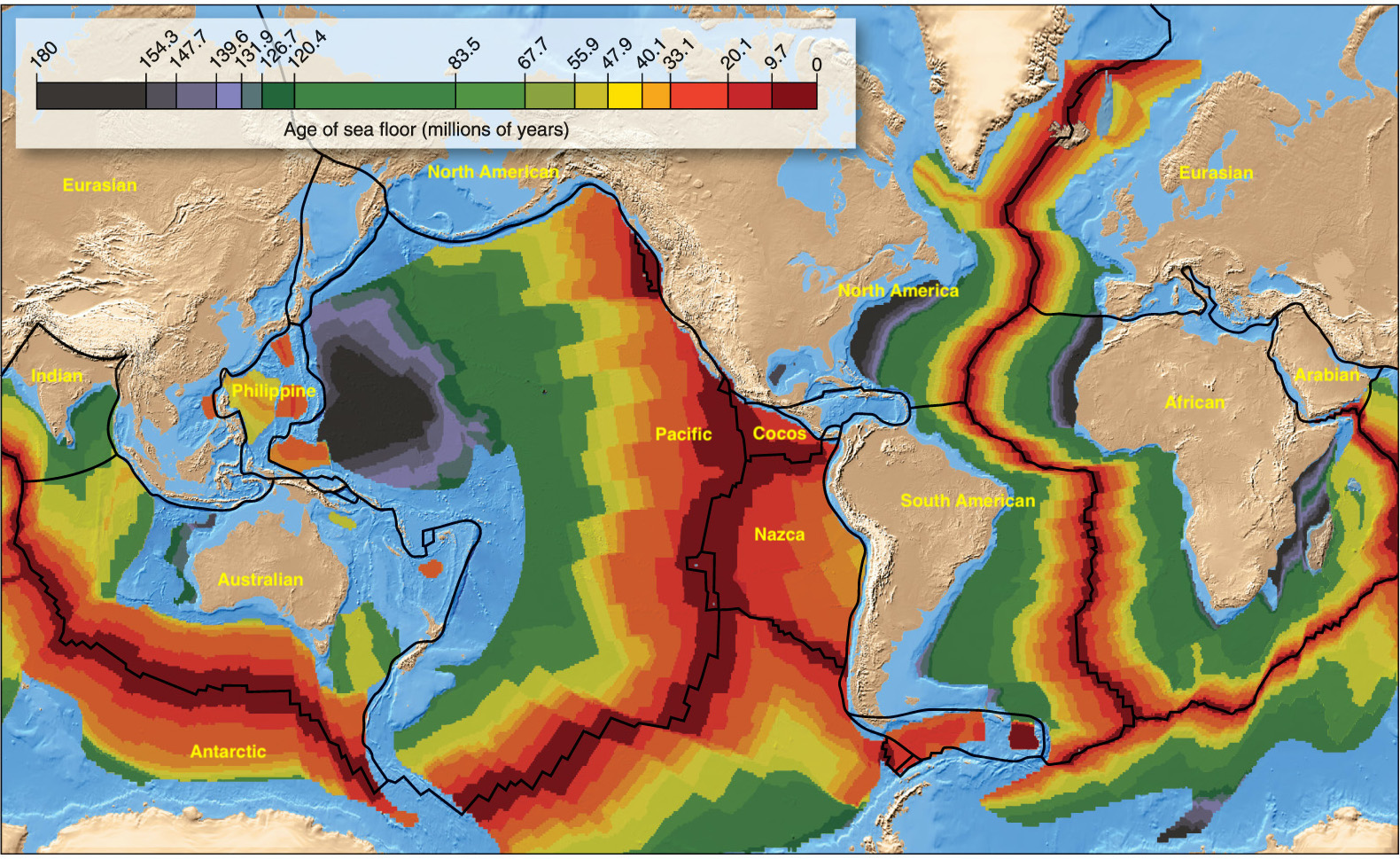
This global map shows the current arrangement of the continents, the names of the major tectonic plates (yellow), and the age of the oceanic crust. [Although the legend says “Age of seafloor”, it’s really the age of the igneous oceanic crust because younger sediments often overlie the igneous rocks on the seafloor]. Notice how the continents of South America and Africa fit together if the Atlantic Ocean is closed. Also notice that the youngest oceanic crust (dark red color) is located in the center of the Atlantic Ocean, at the mid-ocean ridges (MORs; see top diagram). Similarly, the youngest oceanic crust in the Pacific and Indian Oceans is found at the MORs. Notice, too, that there is no oceanic crust older than 180 million years, although we find continental crust as old as 3+ billion years—quite a difference! How can we explain these observations? Crustal age data in the map are from NOAA site.
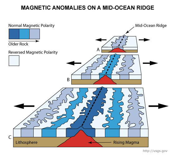
The processes that occur at mid-ocean ridges (MORs) were revealed after new technology, used to better detect enemy submarines, was developed during World War II. A magnetometer carried across the seafloor showed varying magnetic intensities. With further study after the war, geoscientists discovered symmetrical stripes on either side of the MOR that formed during periods of normal magnetic polarity (like now) and periods of reversed magnetic polarity, when the white side of the needle on a compass would have pointed to the south pole rather than to the north pole, like it does now. On the diagram A=oldest time, and C=youngest time.
By the early 60’s, geoscientists realized that new oceanic crust was being created at MORs, which form the boundaries between tectonic plates moving apart from each other (i.e., diverging) in a process called seafloor spreading. As the plates diverge, magma (i.e., molten rock) rises to the seafloor and hardens into solid rock that preserves the ambient magnetic field. When the polarity of Earth’s magnetic field reverses, the newly-formed rock preserves the reversed polarity in the igneous oceanic crust, symmetrically on each side of the MOR. Imagine a conveyor belt moving outward from the MOR, carrying seafloor and any attached continents with it. On the global map above, notice that the North American plate, for example, contains both oceanic and continental crust because it extends from the MOR in the center of the Atlantic Ocean to the western coast of the U.S., where the boundaries are convergent and transform types (to be explored in next two posts).
This reconstruction shows what our planet looked like ~150 million years ago (Ma). The continents had converged into the super-continent called Pangea ~250 Ma, but by 150 Ma, North America and Africa had begun to separate to form the North Atlantic Ocean. South America and Africa began to separate later on, to form the South Atlantic Ocean. The Atlantic Ocean has continued to widen since then. Map from the PALEOMAP Project (www.scotese.com).
The problem with divergent boundaries is that they are mostly hidden beneath ocean water and therefore difficult to observe. Although about 70% of Earth’s volcanism occurs at divergent boundaries, we are rarely able to see the eruptions. Because of the volcanic heat at the MORs, they form long, high mountain ranges on the seafloor; the typical depth at the crest of a MOR is 2,500 m (8,000 feet), whereas the average depth of the ocean is 4,000 m (13,000 feet). The seafloor is deeper away from the MORs because as the oceanic crust moves away from the ridge, the rock cools and contracts, thus sinking to greater depths. Imagine putting your cake in the oven (MOR) where it heats and rises, then pulling your cake out of the oven (crust moves away from the ridge) where it cools and sinks.
There are a few places where volcanism has caused the MOR to extend all the way to the surface of the ocean, most famously at Iceland and the Galapagos Islands (see global map above). These are places where “hot spots” deep within the planet are coincident with a divergent plate boundary, which causes an unusually large amount of magma to be produced and rise up to the seafloor. The country of Iceland is an island that sits on top of the Mid-Atlantic Ridge (left-side map; red triangles are active volcanoes). It is made completely of lava that flows out along fractures (right-side photo) because the island is being continually pulled apart at a rate of ~2.5 cm/yr (1 inch/yr). Here visitors can stand on a divergent plate boundary and see the planet being torn asunder! As the lava moves away on each side of the ridge, it gets eroded by wave action along the edges of the island and eventually sinks beneath the ocean surface. Images from www.geologyin.com.
The 20th century saw discoveries that revolutionized the geological sciences, but a seafloor discovery on the Galapagos Ridge, a MOR between the Cocos and Nazca plates (see global map above), also revolutionized the biological sciences. In 1977, geoscientists discovered hydrothermal vents (hot springs), which they had expected to find, given the heat of volcanic activity along the ridge. What they did not expect to find, since the crests of MORs are well below the photic zone at ~2,500 m depth, was a vast and diverse community of life. Biological scientists returned to the site in 1979 to begin studying the process of chemosynthesis, the basis for a whole new type of ecosystem that needs no light to thrive. Most life on Earth is based on plants or algae that make food using sunlight as the energy for photosynthesis. In environments without sunlight, the energy to make food is provided by chemical processes. In hydrothermal vent communities, bacteria absorb hydrogen sulfide streaming from the vents, and oxidize it to sulfur. They use the chemical energy released during oxidation to combine carbon, hydrogen, and oxygen into sugar molecules (i.e., food) that is consumed by other organisms.
Vent communities contain abundant and exotic life forms previously unknown to science. For example, tube worms (shown in photo above at a vent with black smokers) can grow up to more than 2 m (6.5 feet) tall! They have no mouth or digestive tract, and like parasitic worms, they absorb nutrients that are produced by the bacteria in their tissues. Tube worms are red because they contain hemoglobin that combines with hydrogen sulfide for transfer to chemosynthetic bacteria living in the worm. In return, the bacteria nourish the worm with carbon compounds, a symbiotic relationship. Image from NOAA Office of Ocean Exploration and Research.
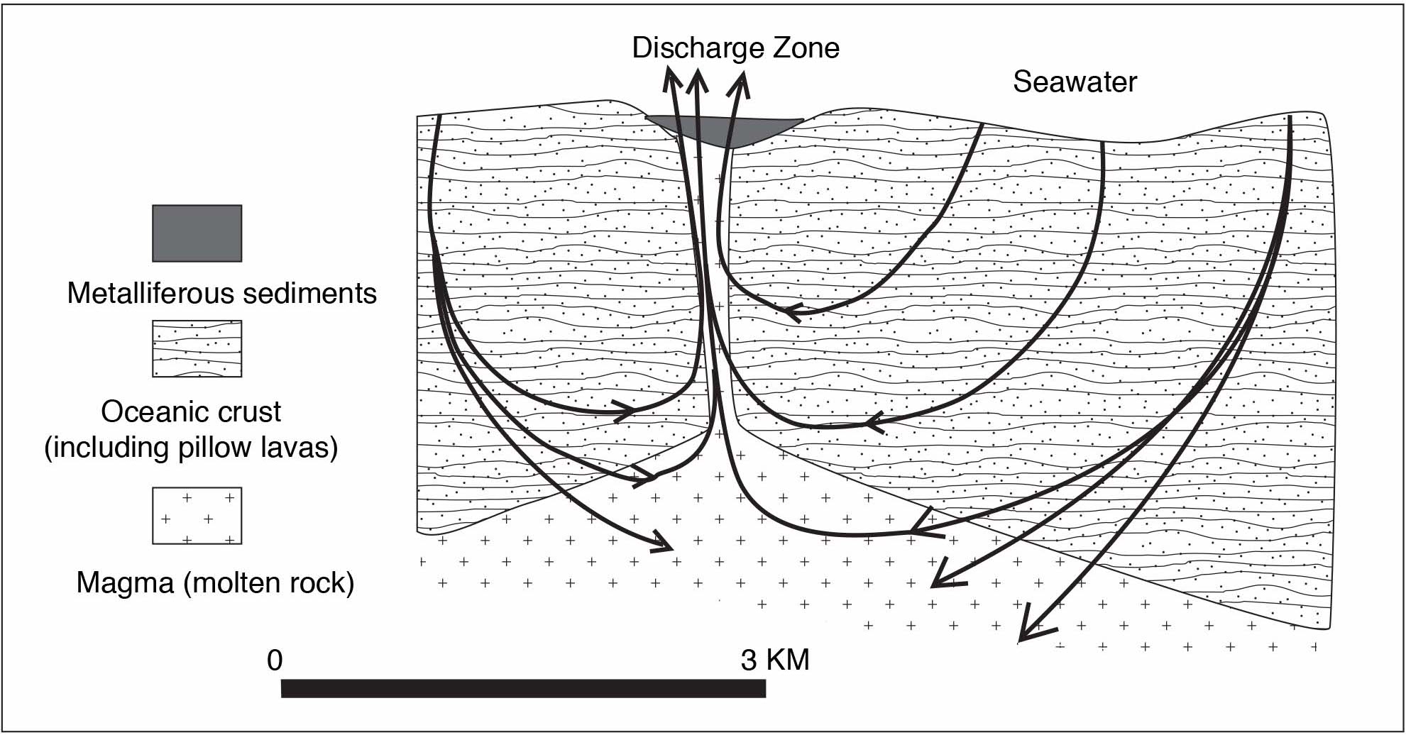
This graphic, created when I was teaching introductory oceanography courses, shows how hydrothermal circulation (black arrows) creates hydrothermal vents at the seafloor of MORs (the discharge zone is in a narrow valley at the crest of the ridge). Because oceanic crust is being pulled apart at the crest of the ridges, faults and fractures are created that allow ocean water to percolate down into the newly-created igneous rock. As the water flows, it picks up minerals from the rock and is heated by the hot magma. Some of the water then flows upward to be emitted back into the ocean via hydrothermal vent features called black or white smokers (depending on the amount of mineral content) or chimneys. This super-heated water can achieve temperatures over 400°C (750°F).
Because most MORs are located deep in the ocean, the landscape there is difficult to visualize. This artistic rendering shows the landscape at a vent community on the crest of a MOR. Shown are pillow lava, a hydrothermal vent (white smoker), a variety of organisms (e.g., tube worms, large clams, crabs, fish), and Alvin, an important tool for deep-water exploration. Alvin is a human-occupied submersible that was created in the 1960s and has been a vehicle used for many discoveries of hydrothermal vents and their other-worldly communities of life. The image is fromhttps://dusk.geo.orst.edu/oceans/tubeworm_bbq.html.
Since the 1970s, many new technologies have been developed for seafloor exploration—most are remotely-operated vehicles (ROVs) that scientists can safely operate from a ship or land-based location. For more information about these technologies, see MBARI’s site about their robotic vehicles: https://www.mbari.org/at-sea/vehicles/.
We can also learn about seafloor processes from on-land exposures, where oceanic crust has been uplifted and become part of a continent. There are many places on the U.S. West Coast to see pieces of ocean crust, where the Pacific seafloor has moved away from a MOR and eventually made it to the continental edge and gotten caught up in a convergent plate boundary (topic of my next post). There, compressive forces uplift the oceanic crust and attach parts of it to the continent. When lava flows out onto the seafloor at MORs, the cold water chills the outer part of the lava and tubular forms called pillow lava are created. The left-side photo above shows pillow lava (and clams) that formed on the seafloor along the Galapagos MOR. The right-side photo is an on-land exposure of pillow lava in the Golden Gate Recreational Area about an hour north of San Francisco. Seafloor image from Smithsonian web site: https://volcano.si.edu/volcano.cfm?vn=334070.
On-land exposures of oceanic crust are important locations for economically-important mineral deposits. Metal-rich seafloor sediments, with high amounts of iron, manganese, nickel, zinc, copper, cobalt, lead, and other metals have been discovered near MORs in the Atlantic, Pacific, and Indian Oceans. Geologists now understand the origin of these ore deposits—they are pieces of ocean crust subsequently pushed onto land.
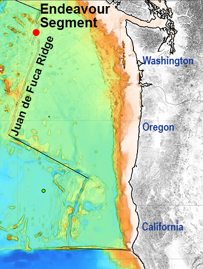
Some MORs are located closer to the edges of an ocean than its middle. A prime example is the Juan de Fuca Ridge, located about 150–500 km (150–300 miles) offshore from northern California, Oregon, and Washington. This MOR has been intensively studied because of its proximity to land. The Endeavour Segment is a very active part of the MOR, where nearly 600 hydrothermal chimneys have been discovered. On the map, the colors correspond to water depth—white and orange colors signify shallowest parts of the seafloor whereas dark blue signifies the deepest parts. Image from https://www.mbari.org/endeavor-hydrothermal-chimneys/. MBARI=Monterey Bay Aquarium Research Institute. This page also contains images of the chimneys.
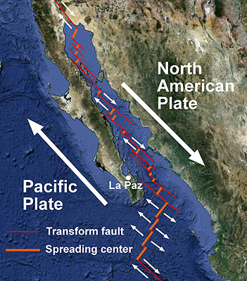
MBARI has also been conducting research at the nascent MOR that began pulling Baja California from mainland Mexico about 7 million years ago. At that time, the East Pacific Rise (MOR between the Pacific and Cocos/Nazca/Antarctic plates; see global map above) began extending northward to where it connects to the San Andreas transform plate boundary in southern California. Map from https://www.mbari.org/the-geologic-setting-of-the-gulf-of-california/. Other nascent MORs are found in NW Africa, where the Arabian plate is beginning to separate from the African continent.
Once geoscientists realized that Earth was being pulled apart at mid-ocean ridges, and that new oceanic crust was being created there, a new question arose: if Earth is not expanding, oceanic crust must also be destroyed somewhere. Looking at the global map above, we can now see why oceanic crust is so much younger than continental crust. All around the edge of the Pacific Ocean are black lines that are subduction zones where oceanic crust is being destroyed (the so-called “ring of fire”). We will explore this type of (convergent) plate boundary in the next post.


👍. Happy New Year. 🥳 Janie
Sent from my iPad
>
Happy 2021 to all!! 🎉